Lupine Publishers Group
Lupine Publishers
Menu
ISSN: 2637-6652
Research Article(ISSN: 2637-6652) 
Spatial Variation of Soil Texture in the World Heritage Site of Indian Sundarbans Volume 2 - Issue 5
Arpita Saha1*, Arpan Mitra2, Nabonita Pal1, Sufia Zaman1 and Abhijit Mitra3
- 1Department of Oceanography, India
- 2A Mitra & Company, India
- 3Department of Marine Science, India
Received:May 23, 2019; Published: May 28, 2019
Corresponding author:Arpita Saha, Department of Oceanography, India
DOI: 10.32474/MAOPS.2019.02.000146
Abstract
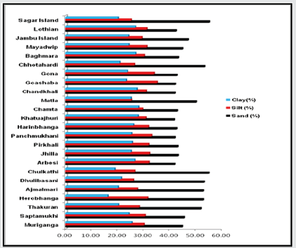
A study was conducted on soil texture in 24 stations distributed in the western, eastern and central Indian Sundarbans during 2017. The region is dominated by mangroves although the western sector is more prone to anthropogenic disturbances. It is observed that in all the stations sand exhibited maximum percentage (32% - 55%), followed by silt (25%-32%) and clay (11%- 25%).
Keywords:Soil texture; Indian sundarbans; Mangroves
Introduction
The important morphotypes of deltaic Sundarbans include beaches, mudflats, coastal dunes, sand flats, estuaries, creeks, inlets and mangrove swamps [1]. The temperature is moderate due to its proximity to the Bay of Bengal in the south. Average annual maximum temperature is around 35 °C. The summer (premonsoon) extends from the mid of March to mid-June, and the winter (post-monsoon) from mid-November to February. The monsoon usually sets in around the mid of June and lasts up to the mid of October. Rough weather with frequent cyclonic depressions occurs during mid-March to mid-September. Average annual rainfall is 1920 mm. Average humidity is about 82% and is more or less uniform throughout the year. This unique ecosystem is also the home ground of Royal Bengal Tiger (Panthera tigris tigris). The deltaic complex sustains 102 islands, 48 of which are inhabited. The ecosystem is extremely prone to erosion, accretion, tidal surges and several natural disasters, which directly affect the top soil and the subsequent soil texture. The average tidal amplitude is around 3.0m. We conducted survey at 24 stations in the Indian Sundarban region in February, 2018. Station selection was primarily based considering the blocks in Indian Sundarban. The present study has great implication as the agricultural productivity, pisciculture and construction of ecotourism units in this deltaic complex stand on the foundation of soil texture.
Material and Methods
Sampling stations
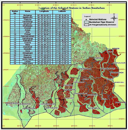
The Sundarban mangrove ecosystem covering about one million ha in the deltaic complex of the Rivers Ganga, Brahmaputra and Meghna is shared between Bangladesh (62%) and India (38%) and is the world’s largest coastal wetland. Enormous load of sediments carried by the rivers contribute to its expansion and dynamics. The Indian Sundarban (between 21°13‘N and 22°40‘ N latitude and 88°03‘E and 89°07‘E longitude) is bordered by Bangladesh in the east, the Hooghly River (a continuation of the River Ganga) in the west, the Dampier and Hodges line in the north, and the Bay of Bengal in the south. 24 stations were selected in the Indian Sundarban region in February, 2018 to carry out this programme (Figure 1).
Experimental analysis
Figure 1 represents our study site in which sampling plots of 10m × 5m were considered for each station. Care was taken to collect the samples within the same distance from the estuarine edge, tidal creeks and the same micro-topography. Under such conditions, spatial variability of external parameters such as tidal amplitude and frequency of inundation inputs of material from the adjacent bay/estuary and soil granulometry and salinity are minimal [2-4]. Because of regular tidal flushing sediment input and riverine inputs of silt and clay, a significant spatial difference of soil texture is noted in Indian Sundarbans. Study of soil texture is important as the agricultural productivity in Indian Sundarbans is dependent on water holding capacity of the soil, which in turn is regulated by the texture of Sundarban soil. The vast mangrove vegetation in Indian Sundarbans produces litter and detritus which finally get transformed into silt and clay. Sand is brought in the system through tidal actions from the Texture analysis Mechanical analysis for texture was carried out using the International Pipette method. In this method, the soil sample was treated to remove the organic matter with hydrogen peroxide. Soluble matter was removed by washing and filtering with Pasteur- Chamber land suction filters. The sample was dried and weighed, and this weight was the basis of calculation of percentages of material in each size class. The results were finally used in textural classification.
Results and Discussion
In the soil of Indian Sundarbans, the percentage of sand is higher, followed by that of silt and clay. So, the soil is mainly sandy- loam in nature. Such soils have visible particles of sand mixed into the soil. When sandy loams soils are compressed, they hold their shape but break apart easily. Such soils have low water holding capacity, high permeability and low nutrient storage capacity. The percentage of sand in the soil is maximum in the central sector followed by the western and eastern sectors (Figure 2). Soils in Indian Sundarbans are mainly loamy in nature. The soil texture varies from sandyloam to clay- loam. Study of soil texture has several implications. It helps to determine how much water will be able to pass through the soil, how much water the soil can store, and the ability of sodium to bind to the soil. In the present study it is found that the soils in the central sector of Indian Sundarbans (station 3, station 4, station 5, station 6, station 7, station 15 are station 19) are dominated by sand (average 52.53%), which is an indication of decreased transference of silt and clay through fresh water. The siltation of Bidyadhari since the late 15th century may be the best possible reason for this textural variation [1,5-10]. Silt and clay are contributed in the soil of the present study area through riverine discharges via Hooghly and Muriganga in the western sector and through several creeks connected with Harinbhanga River in the eastern most boarder of Indian Sundarbans. The present study has great significance in the agricultural sector as the present study area is a mono cropping zone due to high salinity. Under normal irrigation practices sandy soils will naturally be able to flush more water through the root zone than clay and silty types of soil. The end result is that sandy soils can withstand higher salinity irrigation because more dissolved salts can be removed from the root zone by leaching. This lead us to conclude that clay soils are at a greater risk than course textured sandy soils as considerable sodium get accumulated resulting in stunted growth of the vegetation.
References
- Chaudhuri AB, Choudhury A (1994) Mangroves of the Sundarbans. The World Conservation Union, Dhaka, Bangladesh.
- Ovalle ARC, Rezende CE, Lacerda LD, Silva CAR (1990) Factors affecting the hydrochemistry of a mangrove tidal creek, Sepetiba Bay, Brazil. Estuar Coast Shelf Sci 31(5): 639-650.
- Lacerda LD, Carvalho CEV, Tanizaki KF, Ovalle ARC, Rezende CE (1993) The biogeochemistry and trace metals distribution of mangrove rhizospheres. Biotropica 25(3): 251-256.
- Tanizaki KF (1994) Biogeoquímica de metais pesados na rizosfera de plantas de um manguezal do Rio de Janeiro, M.Sc. Thesis, Departamento de Geoquímica, Universidade Federal Fluminense, Niterói, pp. 67.
- A Mitra Sensitivity of Mangrove ecosystem to changing Climate. Springer.
- Mitra A, Zaman S (2014) Carbon Sequestration by Coastal Floral Community. The Energy and Resources Institute (TERI), TERI Press, India.
- Mitra A, Zaman S (2015) Blue carbon reservoir of the blue planet, Springer.
- Mitra A, Zaman S (2016) Basics of Marine and Estuarine Ecology, Springer.
- Trivedi S, Zaman S, Ray Chaudhuri T, Pramanick P, Fazli P, et al. (2016) Inter-annual variation of salinity in Indian Sundarbans. Indian Journal of Geo-Marine Science 45(3): 410-415.
- Mitra A, Sundaresan J, Banerjee K, Agarwal SK (2017) Environmental coastguards. Published by CSIR-National Institute of Science Communication and Information Resources (CSIR-NISCAIR).

Top Editors
-

Mark E Smith
Bio chemistry
University of Texas Medical Branch, USA -

Lawrence A Presley
Department of Criminal Justice
Liberty University, USA -

Thomas W Miller
Department of Psychiatry
University of Kentucky, USA -

Gjumrakch Aliev
Department of Medicine
Gally International Biomedical Research & Consulting LLC, USA -

Christopher Bryant
Department of Urbanisation and Agricultural
Montreal university, USA -

Robert William Frare
Oral & Maxillofacial Pathology
New York University, USA -

Rudolph Modesto Navari
Gastroenterology and Hepatology
University of Alabama, UK -

Andrew Hague
Department of Medicine
Universities of Bradford, UK -

George Gregory Buttigieg
Maltese College of Obstetrics and Gynaecology, Europe -

Chen-Hsiung Yeh
Oncology
Circulogene Theranostics, England -
.png)
Emilio Bucio-Carrillo
Radiation Chemistry
National University of Mexico, USA -
.jpg)
Casey J Grenier
Analytical Chemistry
Wentworth Institute of Technology, USA -
Hany Atalah
Minimally Invasive Surgery
Mercer University school of Medicine, USA -

Abu-Hussein Muhamad
Pediatric Dentistry
University of Athens , Greece

The annual scholar awards from Lupine Publishers honor a selected number Read More...


