Lupine Publishers Group
Lupine Publishers
Menu
ISSN: 2637-6652
Research Article(ISSN: 2637-6652) 
Preliminary Study on Fogs in the Guanabara Bay (Rio de Janeiro-Brazil) Associated with Astronomical Tide Volume 1 - Issue 3
Ana Cristina Pinto de Almeida Palmeira*
- Federal University of Rio de Janeiro (UFRJ), Brazil
Received: March 23, 2018; Published: March 27, 2018
Corresponding author: Ana Cristina Pinto de Almeida Palmeira, Federal University of Rio de Janeiro (UFRJ), Brazil
DOI: 10.32474/MAOPS.2018.01.000112
Abstract
Studies on fogs report a great diversity of physical processes involved besides a strong dependence of the place of formation. The different possibilities of the advective, radiative and mixed patterns, associated or not to precipitation, make difficult the exact characterization of its life cycle and, consequently, its predictability. However, the advancement of satellite image visualization techniques as well as the increase in the database available free of charge at the national (CPTEC / INPE) and international (NOAA) levels, have improved the detection of this phenomenon after being formed. This work begins a quantification of the occurrence of fogs in the vicinity of Guanabara Bay through data obtained at the Santos Dummond (SBRJ) and Antonio Carlos Jobim - Galeao International Airports (SBGL), located in the city of Rio de Janeiro, evaluating its thicknesses and its relations with the astronomical tides. In addition, a case study was chosen to subsidize early investigations, and relationships with phenomena of synoptic scale.
Abbrevations: PODAAC: Physical Oceanography Distributed Active Archieve Center; SST: Surface Temperature of the Sea
Introduction
The formation of fog is directly associated to the local circulations that are established on a region. Environments with moisture rarefaction will have low rates of fog occurrence, but in areas close to reservoirs such as lakes, rivers, seas and oceans, are preferentially subject to the presence of fog due to the possibility of establishing thermally induced local circulations between the liquid surfaces and terrestrial, such as sea breezes, which provide plots of moist air to the interior of continental areas (CONDE & SILVA DIAS, 1999). Despite the importance of the fog forecast, there are still few studies on the subject in Brazil (DAMASCENO, 2008). Several initiatives have been taken to allow the fog to be mathematically modeled, however, the results are still not satisfactory. The forecast of fogs can be done through different methods: objectives, statistics and modeling. In this last one can be used atmospheric models robust or specifically for fogs. However, all of them go into detail in each of the events and in the separation of contributions from the different temporal and spatial scales involved. The Bay of Guanabara, located in the state of Rio de Janeiro, is an estuary with marked influence of the surface temperature of the sea (SST), which varies, among other phenomena, according to the effect of the astronomical tides. This fact stems from the incursion of colder waters, which border the Rio de Janeiro coast due to the resurgence phenomenon in the Cabo Frio region. Preliminary studies in different estuaries suggest the association of this entry of cold water as a trigger for the formation of fog. The fogs can be classified according to the type of formation, duration and visibility. It is important to compare different cases within the same region in order to determine the frequency and type of predominant fog at the site.
Objective
The main objective of this work was to map the fog occurrences in the area of Rio de Janeiro between 2001-2011, following their areas of activity, their intensities, their thicknesses, their behaviors correlating them with the synoptic scenarios of each event , with the aid of satellites images intersected in different channels.
The next step was to study a case, emphasizing the contribution of TSM and tide in this estuary, based on METAR (Redmet) data from the Santos Dummont (SBRJ) and the International Antonio Carlos Jobim (SBGL) airports, bordering the Guanabara Bay [1,2].
Methodology
From the selected fogs according to the intensity, duration and current tide, it was tried to treat the TSM data of the PODAAC (Physical Oceanography Distributed Active Archieve Center) / REMO (Oceanographic Modeling and Observation Network) project, SIMCOSTA project, in addition to analyzing the wind patterns and satellite images in different channels.
Results Obtained
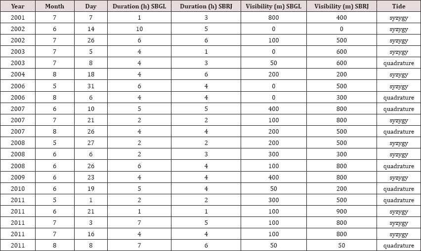
Through (Table 1), it was observed that on average the duration of the fog was higher in the SBGL, with an average value of 4.28 hours, versus 3.71 hours in the SBRJ. In addition, visibility was further impaired at Galeao airport, with total loss of visibility on 3 occasions, compared to only 1 time in the SBRJ. It can also be noticed that, in general, the fog was more intense in the SBGL than in the SBRJ. A brief case study was then initiated, seeking to analyze the fog that occurred on August 1, 2015. This phenomenon reduced visibility to 800 meters, closing Santos Dumont airport between 05:00 and 08:00 min, according to the data from Infraero. It is interesting to note that the current tide was syzygy, causing higher elevations in the mean sea level and consequently entering more seawater into the Guanabara Bay. The sea surface temperature measured by the SIMCOSTA project float was 22°C, a cold temperature for the coast of Rio de Janeiro, but not considered a typical coastal resurgence (below 21°C due to the outcrop of the central Atlantic water South). In the following figures, the pressure field with high pressure predominance, the weak North-Northeast winds and the estimated position of the fog in Guanabara Bay are indicated by the aid of satellites, since the fogs can be analyzed from the persistence of low clouds in the same place, having dissipation and little or no movement. The beginning of the fog occurred in the nocturnal period, which makes impossible the analysis of the visible channel. In addition, the images in the Infrared channel presented better than the water vapor channel, to identify the fog, which is why they were not shown here.
Table 1: Relation between the fog and the astronomical tides.

Conclusion
The fact that there are, on average, longer and stronger fogs in the SBGL airport region, proves the need for further study of the effects of the tides and the Guanabara Bay region itself, since the tide is also influenced by the internal currents of this body of water. In addition, the SBGL has a distribution between syzygy and quadrature egalitarian, suggesting to be less affected by the tide. However, the SBRJ indicated a strong SST influence driven by the tide of syzygy, since the atmospheric patterns did not exert significant influence. There is a predominance of winter fog in Rio de Janeiro, due to the nocturnal cooling, indicating a strong radiative pattern in the occurrences.
References
- CONDE, FC, SILVA FAUS, Dias MAF, Maria A (1999) Caracterização das condiÝões atmosféricas durante a ocorrência de nevoeiro em São Paulo: um estudo de caso. In: Congresso Brasileiro de Meteorologia.
- Relatório de Pesquisa (2008) Análise de frequência e ocorrência de nevoeiro no aeroporto internacional Afonso Pena-Curitiba/PR. Relatorio de Pesquisa (Especialização em Meteorologia Aeronáutica)-Instituto de Controle do Espafo Aereo, Curitiba, Brazil.

Top Editors
-

Mark E Smith
Bio chemistry
University of Texas Medical Branch, USA -

Lawrence A Presley
Department of Criminal Justice
Liberty University, USA -

Thomas W Miller
Department of Psychiatry
University of Kentucky, USA -

Gjumrakch Aliev
Department of Medicine
Gally International Biomedical Research & Consulting LLC, USA -

Christopher Bryant
Department of Urbanisation and Agricultural
Montreal university, USA -

Robert William Frare
Oral & Maxillofacial Pathology
New York University, USA -

Rudolph Modesto Navari
Gastroenterology and Hepatology
University of Alabama, UK -

Andrew Hague
Department of Medicine
Universities of Bradford, UK -

George Gregory Buttigieg
Maltese College of Obstetrics and Gynaecology, Europe -

Chen-Hsiung Yeh
Oncology
Circulogene Theranostics, England -
.png)
Emilio Bucio-Carrillo
Radiation Chemistry
National University of Mexico, USA -
.jpg)
Casey J Grenier
Analytical Chemistry
Wentworth Institute of Technology, USA -
Hany Atalah
Minimally Invasive Surgery
Mercer University school of Medicine, USA -

Abu-Hussein Muhamad
Pediatric Dentistry
University of Athens , Greece

The annual scholar awards from Lupine Publishers honor a selected number Read More...


