Lupine Publishers Group
Lupine Publishers
Menu
ISSN: 2637-6652
Research Article(ISSN: 2637-6652) 
Impact Study of the Tropical Cyclone “Kirrily” to the Southeast Mollucas & West Papua Areas on 26-29 April 2009 Volume 1 - Issue 5
Paulus Agus Winarso* and Yusa Sudjana
- State College Meteorology Climatology & Geophysics,Indonesia.
Received: May 25, 2018; Published: June 07, 2018
Corresponding author: Paulus Agus Winarso, State College Meteorology Climatology & Geophysics, Indonesia
DOI: 10.32474/MAOPS.2018.01.000125
Abstract
Tropical cyclone could be one of the weather phenomenons that it developed in the low latitudes or near the equator line. One of rare occurrence of tropical cyclone in the low latitude would be generated and developed over Southeast Mollucca waters of the so called Kirrily during period 26-29 April 2009. The rare Tropical Cyclone Kirrily over these waters might cause and give impact over Southeast Moluccas and West Papua islands. The data and method would apply from direct meteorological observations, data from ECMWF model and cloud pictures condition from satellite imagery with descriptic and analytic method for studying impact tropical cyclone to the weather system in Southeast Mollucas and West Papua islands. Hopefully interesting result finding could be found in this study.
Keywords: Mollucas; Papua; Tropical Cyclone; Rainfall; Wind Speed
Introduction
Indonesia Maritime Continent was located between the two continents (Asia and Australia) and the two oceans (India and Pacific). As maritime continent area lying in the tropical area, the weather system of the area would be affected from its environment warm waters and land such that convective procceses play important role in the development the stormy weather. Tropical cyclone would be result from the stormy weather as part regional atmospheric phenomenon to affect the local weather system (Rajab, 2011). The world scientist in atmsopheric sciences under Tropical Meteorological Research of the World Meteorological Organization and supporting with Khotimah [1] stated that over low latitudes under 10 degrees both southern and northern hemisphere, the tropical cyclone would be rare to develop. The development of the tropical cyclone “Kirrily” over Southeast Mollucca waters would be interesting to be study its impact to the weather system over its surrounding environment.
Climatologically, area would be favorable for developing of the tropical cyclone over Indonesia Maritime Continent area to be along the northern hemisphere extending from Pacific Ocean north West Papua, Sulawesi sea, South China Sea up to Northwest India Ocean and along southern hemisphere north Australia waters, Timor Sea, India Ocean southern Bali and Java Islands up to Southwest India ocean. Based upon the tropical cyclone record under Meteorological Climatological and Geophysics Agency that over Southeast Molluca had never been generated from latest 30 years ago until 2009. Life time of the tropical cyclone Kirrily would be on 27-28 April 2009 (2 days) over latitude below 10 degrees South, this atmospheric condition would be unusual and strange weather system. It could be interesting to be studied especially its impact to the weather system over surrounding area such as Southeast Molucca Islands and Southern area of Western Papua. Tropical cyclone Kirrily was intially observed on 6.5 degrees South and 131.4 degrees East (almost closed position to the equator (Khotimah et.al, [2]).
Southern Mollucca and West Papua Islands would have climatic system almost to be similar over mosth southern hemisphere of IMC with end of year beginning year having westerly monsoonal wind with coincide with wet season and reversal condition in the middle of the year with easterly monsoonal with dry season. How would be the weather system in these areas when tropical cyclone would be generated? This interesting question would be answered through this study emphasizing impact the weather system to this area [3]. The purpose of this study would give description the weather system over Southeastern Mollucca and West Papua Islands as part learning to the atmospheric phenomena over IMC. The learning of the impact study tropical cyclone would like to discuss the data and method also the discussion for finding and investigation the impact tropical cyclone to the weather system during a week of end April 2009. Further exploration of the learning study of the atmospheric condition would be proposed for further study and research to learn physical processes in the atmosphere [4].
Data and Method
For this study, the meteorological data would be used as follows:
a) Meteorological data especially daily rainfall from Meteorological Stations suh as Tual, Saumlaki from Mollucca Islands and Timika from West Papua area.
b) Meorological model data from European Center for Medium Weather Forecast with spatial resolution 1°x1° longitude/latitude of specific humidity.
c) Cloud Picture from satellite Imagery.
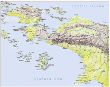
Location of the study would be part of the areas of Mollucca and West Papua Province of Indonesia extending between 5°-15° south and 110°-155° East with coverage area Tual, Saumlaki and Timika. The area of this study would be shown in figure 1 as follows.
The method in this study would be descriptic and analytic of the using temporal and spatial as it was described earlier with focusing the regional and local scales of atmospheric motion. The regional scale of atmospheric motion would like to study distribution of the cloud cover from satellite imagery to trace the tropical cyclone path [5], the wind flow at the low level and distribution of the moisture transport. The local scale would like to study rainfall observation from the three meteorological stations from Saumlaki and Tual in Mollucca and Timika in West Papua. The four day period from 26th up to 29th April would be the course of the study to study impact to the weather system over the study area.
Result and Discussion
The tropical cyclone Kirrily would be unusual atmospheric condition because certain physical reason such as:
d) life time or existence of the tropical cyclone was around three days (27-29 April 2009),
e) Existence of the tropical cyclone was between 7- 4 degrees South (low latitudes),
f) Trajectory of the tropical cyclone equatorward (usually most the trajectory tropical cyclone in various places poleward motion to gain coreolis force for their life time).
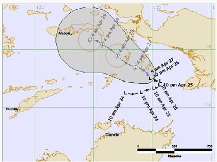
Three aspect cloud enter the tropical cyclone Kirrily on 26-29 April 2019 to be classified as the unusual atmospheric phenomenon especially inside in Indonesia [6]. Based upon the experience as the forecaster and scientist in atmospheric physic under Meteorological Climatological and Geophyiscal Agency in Indonesia since 1974 up to 2017 and searching some information regarding the record of the tropical cyclone activity in the area of South Molluca waters, the tropical cyclone Kirrily would be the first tropical cyclone to be active in Southeast Mollucca waters. The detail of the track of the tropical cyclone Kirrily would be presented in figure 2 as follows,
From figure 2, it could described that before generation of the tropical cyclone, previously Low surface pressure center with abbreviation “L” developed starting 24 April 2009 up to 27 April 2009 [7] at the evening time. Then tropical cyclone generated untill 29 April 2009 at early morning time. For further discussion, it would be better to present the regional aspect of the surface pressure during 26-29 April 2009 as follows,
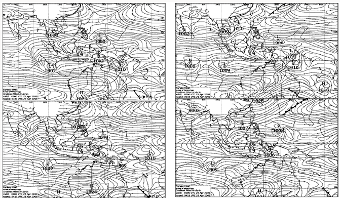
From the surface pressure charts on 26-29 April 2009 on figure 3, over study area of Southeast Mollucca waters would low pressure center in the beginning on 26 April 2009. Then this pressure center decreased in the next day on 27 April 2009. And tropical cyclone Kirrily developed on 28 -29 April 2009. In other word, the tropical cyclone was developed with the surface pressure center with the value of 999 hecto Pascal or milibars [8]. Further study to discuss with surface wind to study and investigate wind flow during existence of the tropical cyclone. As it discussed earlier that period end of the year beginning of the year wind flow over the study area prevails from west and during middle of the year from east. The month of April would classify as transition period of the wind flow from West into from East, otherwise based from the experience calm wind. Detail wind flow during course of the study would be taken from 26-29 April 2009 and they would be presented in figure 4 as follows,
Figure 3: Surface Pressure Charts on the regional perspective of Indonesia on 26-29 April 2009 with the line would isobaric line with L as low pressure center and H as High pressure center (source : www.bom.gov.au).
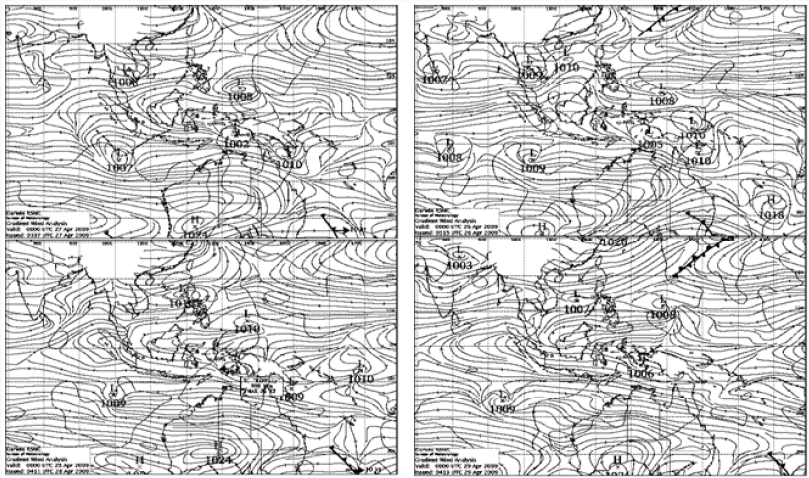
Figure 4: Wind flow on 26-29 April 2009 at 00.00 UTC (Universal Time Conversion) showed easterly wind with calm into weak in speed and circular motion (clockwise motion) aroud tropical cyclone Kirrily (source : www.bom.gov.au).
From the wind flow would describe the easterly wind flow to prevail in regional scale of atmospheric motion. As the wind flow over eastern Papua Island with divergence of the wind flow, this divergence of the easterly wind flow had medium into the strong wind speed. Following the conservation of the absolute vorticity, if the easterly wind flow move on the mountainous barrier over central of Papua island to generate the negative vorticity (clockwise circulation). This condition would encourage the development the tropical cyclone Kirrily initially over Southeast Mollucca waters [9]. Based upon the cloud distribution during the course of the study, there were decreasing of the cloud cover. In the next (figure 5) would like to present cloud distribution from the satellite observation as follows,
Figure 5: Coud distribution from satellite imagery on 26 – 29 April 2009 showed the decreasing cloud distribution with respect of the time (source from www.bom.gov.au).
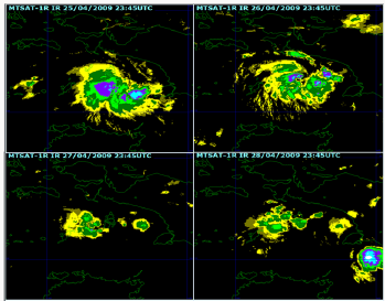
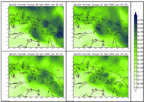
From the figure 5 informed the cloud distribution over the center of the low pressure center (in the beginning 26 April 2009) and over tropical cyclone center (27-28 April 2009) and then over low pressure center in the last day (29 April 2009) [10]. The cloud distribution showed an indication for decreasing of the cloud from beginning to the end. The specific humidity from the model European Center for Medium Weather Forecast (ECMWF). The charts would explain humidity condition durin period 26-29 April 2009. The specific humidity charts from the processing model ECMWF would be presented in the next figure 6 as follows,
From the specific humidity charts from processing ECMWF model, they informed that the specific humidity followed the cloud distribution that from the begining there was high concentration in the atmosphere (Specific humidity unit in gram water vapour in Kilogram of moist air) on 26 April. The speficic humidity followed the cloud distribution. The rainfall observations from Meteorological Stations in the cities of Tual and Saumlaki (Islands over Southeast Mollucca waters) and city of Timika (West Papua). The rainfall record per day during the study would be presented in next figure 7 as follows
Figure 7: Rainfall record in Tual (green clour), Saumlaki (yellow colour) and Timika (green colour) on 26-29 April 2009.
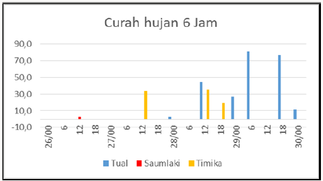
The impact to the weather system in term of the rainfall distribution would be similar with previous meteorological paramaters previously in large scale of the atmospheric motion [11]. Because not so large values of the surface pressure gradient over Southeast Mollucca waters, the monsoon trough would not so develop following wind convergence with decreasing of the humidity over the study area. These atmospheric condition would not be favorable cloud development over wide area except small area with convective cloud activity during the end activity period of the tropical cyclone Kirrily on 29-30 April 2009. Where in this period over the three rainfall observation occurred medium (30 milimetere/day) up to high (70 milimters/day). Meaning to say that tropical cyclone had been developed during period in the of April 2009rainfall intensity cause not so developr or bigguring the studyy As Dari data observasi pada tiga stasiun yang dijadikan sampel, dapat terlihat bahwa wilayah yang terkena dampak berupa peningkatan curah hujan adalah wilayah Tual dan Timika. Tual merupakan wilayah terdekat dari pusat siklon, sehingga awan konvektif hasil aktivitas dari siklon tropis menutupi wilayah Tual selama waktu pengamatan. Awan tersebut luruh pada waktu siklon tropis Kirrily dinyatakan punah dan menjadi hujan. Sedangkan Timika adalah wilayah konvergensi, yang dapat dilihat dari pola pada stramline. Konvergensi ini memicu terbentuknya awan konvektif yang terdeteksi pada tanggal 26 hingga tanggal 28 menutupi wilyah Timika. Awan konvektif ini menyebabkan meningkatnya curah hujan hingga diatas normal pada wilayah Timika [12].
Summary and Conclussion
From above discussion, it could be sumarized as follows,
a. During the end of April 2009 there was occurred the first tropical cyclone with international name of the so called “Kirrilly, where it could be the first tropical cyclone with respect from the record last 1974.
b. Time of occurrence of this tropical cyclone Kirrilly would be in the transition period between westerly monsoon season and easterly monsoon season. It should be interesting to be studied further detailly.
c. As this tropical cyclone Kirrily generated during transition period with possibility of the surface low pressure, weak surface pressure gradient and weak of the wind. But from this study there was mechanic process to support this development beside intense warming episode to be due sun’s declination passing the equator move northward.
d. This tropical cyclone could not so give the impact except local convective cloud development coincide with transtition periode over the study area.
For the conclussion that on the end 2009 over Southeast Mollucca waters, the first tropical cyclone could be recorded and also to rare occurrence as the weather phenomena. For this initial action of the first tropical cyclone, it would not so cause the problem in overal aspect especially loss of life and material. And it would be proposed for further study more deeply in this study.
References
- Khotimah MK, AF Radjab, M Budiarti (2009) Siklon Tropis Kirrily: Anomali di Dekat Ekuator. Buletin Meteorologi dan Geofisika.
- Khotimah MK (2009) Cyclone near equator. Meteorology and Geophysics Bulletins.
- Anonim.
- Bureau of Meteorology Australia (2009) Providing weather charts information and analysis.
- Khotimah, Mia Khusnul (2008) Climatology Tropical Cyclone around Indonesia. Bulletin of Meteorology Climatology and Geophysics, Agency Meteorology Climatology and Geophysics, Jakarta 4(3).
- Sucahyono S, Dedi dan Kukuh Ribudiyanto (2013) Weather and Extreme Climate in Indonesia. Puslitbang BMKG, Jakarta.
- Tjasyono HK, Bayong, dan Sri Woro B Harijono (2013) The Equatorial Atmosphere. Meteorology and Geophysics Agency, Jakarta.
- Tjasyono HK, Bayong (2004) Climatology. Second Edition ITB, Bandung.
- Wirjohamidjojo, Soerjadi dan Yunus S Swarinoto (2013) Synoptic Meteorology. Analysis and Assessment of Synoptic Weather Analysis Results. Puslitbang BMKG, Jakarta.
- Chie Yokoyama, Yukari N Takayabu (2008) A Statistical Study on Rain Characteristics of Tropical Cyclones Using TRMM Satellite Data. Center for Climate System Research, University of Tokyo, Japan.
- Zakir Ahmad, Widada Sulistya dan Mia Khusnul Khotimah (2010) Tropical Weather Operational Perspective. Meteorology Climatology and Geophysics Agency, Jakarta.
- Zehr RM (1992) Tropical cyclogenesis in the Western North Pacific. PhD Dissertation. Colorado State University, Fort Collins, CO 53(9): pp 4723.

Top Editors
-

Mark E Smith
Bio chemistry
University of Texas Medical Branch, USA -

Lawrence A Presley
Department of Criminal Justice
Liberty University, USA -

Thomas W Miller
Department of Psychiatry
University of Kentucky, USA -

Gjumrakch Aliev
Department of Medicine
Gally International Biomedical Research & Consulting LLC, USA -

Christopher Bryant
Department of Urbanisation and Agricultural
Montreal university, USA -

Robert William Frare
Oral & Maxillofacial Pathology
New York University, USA -

Rudolph Modesto Navari
Gastroenterology and Hepatology
University of Alabama, UK -

Andrew Hague
Department of Medicine
Universities of Bradford, UK -

George Gregory Buttigieg
Maltese College of Obstetrics and Gynaecology, Europe -

Chen-Hsiung Yeh
Oncology
Circulogene Theranostics, England -
.png)
Emilio Bucio-Carrillo
Radiation Chemistry
National University of Mexico, USA -
.jpg)
Casey J Grenier
Analytical Chemistry
Wentworth Institute of Technology, USA -
Hany Atalah
Minimally Invasive Surgery
Mercer University school of Medicine, USA -

Abu-Hussein Muhamad
Pediatric Dentistry
University of Athens , Greece

The annual scholar awards from Lupine Publishers honor a selected number Read More...


