


Lupine Publishers Group
Lupine Publishers
ISSN: 2637-6652
Review Article (ISSN: 2637-6652) 
Along Track Interferometry TANDEM-X Satellite Data for Modelling Sea Surface Pattern Variations Volume 2 - Issue 4
Received: March 18, 2019; Published: March 25, 2019
Corresponding author: Maged Marghany, Geomatika University College, WP Kuala Lumpur, Malaysia
DOI: 10.32474/MAOPS.2019.02.000144
Abstract
This investigation is the novel study, which is contacted along the Malaysian coastal water to implement the potential of TanDEM-X satellite data for retrieving sea surface current. In this view, the main objective of this investigation is to exam the multichannel MAP height estimator for retrieving sea surface current pattern as a function of the tidal elevation. In-deed, TanDEM-X satellite data have an inordinate prospective for modeling the sea surface parameters, for instance, sea surface current flows and the physical parameters of ocean wave spectra i.e. wavelength and significant wave height. Consequently, TanDEM-X satellite data are the expression of the satellite operation flying with the two satellites in an exactingly measured substance with a consistent baseline between 250 and 500m. In this understanding, the set of TanDEM-X satellite data are explored by using along track interferometry which is optimized by MAP algorithm. The investigation reveals that the MAP algorithm has excellent performance with the lowest RMSE of ±0.013. Additionally, the MAP algorithm can authenticate the spatial variability of coastal water from TanDEM-X satellite data. Concluding, TanDEMX data exposes a fabulous assurance for modeling the sea surface current flow with X-band.
Keywords:TanDEM-X satellite data; MAP height estimator algorithm; Sea surface current; Tidal elevation; Along-Track Interferometry
Introduction
Nowadays, there is no a novel study conducts advanced microwave remote sensing along the coastal waters of southeast Asia. Indeed, most of the physical oceanography studies are carried on the southeast Asia coastal waters are based on simply collected data or archived data. In this view, the physical oceanography research in institutes of southeast Asia depends on the classical theories and traditional physical oceanography data collections. For instance, Malaysian physical oceanography researchers cannot solve or deliver precise theory for ending of MH370. In these regards, such advanced and novel approaches are required to study the coastal waters of southeast Asia.
Satellite microwave data, such as synthetic aperture radar (SAR) have the great potential for retrieving ocean dynamic parameters, for instance, ocean surface current and ocean wave dynamic [1]. Recently, the high resolution of SAR sensors such as TerraSar-X, RADARSAT-2, ALOS PALSAR and the foremost three of the Italian satellite of COSMO-SkyMed have been commenced. Once the four satellites in the COSMO-SkyMed constellation develop functioning with a tiny resume time of little hours should be conceivable [2]. Nevertheless, the initial three of the COSMO-SkyMed, ALOS PALSAR, and RADARSAT-2, satellites data are the cross-track interferometry, which does not allow of determining neither coastal water flow nor coastal water level changing. In this regard, the TerraSAR-X satellite data using an along-track interferometric proficiency which has simply permitted the quantity of sea surface speed. Additional, phase alterations between the co-registered pixels of an image pair are consistent to Doppler frequency shifts of the signal backscattered and accordingly to line-of-sight velocities of the scatterers. In this view, phase alterations include influences of surface flows and of the dynamic of wave movement. As a result, the retrieving of tidal current flow operating both of TerraSAR-X and Tan-DEM-X. These can be depleted to regulate precisely coastal water height fluctuations. The TerraSAR-X can regulate perfectly the Digital Surface Model (DSM), which a depiction of a surface containing topographies exceeding the terrain height, for example, plants and constructions through precision of 2m. Moreover, TanDEM-X involves dual high-resolution imaging SAR data. In this understanding, both TerraSAR-X and TanDEM-X are hovering in tandem and establishing an enormous radar interferometer with an anticipated competence of creating a comprehensive DSM through a perpendicular resolution of 2m, exceeding whatever obtainable currently from space [2]. Consistent with Romeiser et al. [3], with the usual helical revolution configuration, the dual satellites ensure an along-track gap between 0 at the northern- and southern utmost locations of the orbit and approximately 550 m over the equator, restrictive the district of convenient baselines for inter-satellite interferometry above the sea surface to restricted space crews far-off the north and south. In districts of elongated along-track baselines, the data characteristic undergoes since sequential decorrelation of the signal backscattered. Nonetheless, the TanDEM-X geometry constructions acquire adjusted from period to period to enhance the cross-track interferometry performing in coastal water height fluctuations and surface stream flows attentions [4].
On the word of Yoon et al. [5], the phase computation is a foremost encounter to regulate surplus precise height. This is because of the calculated phase differences are assumed as a wrapped phase of the primary quantities of a scale –π to π, hence the actuality vague contained by multiples of 2π [6-8]. This technique generates phase leaps between nearby pixels. The smooth function is depleted to resolve phase leap through adding or detracting multiples of 2π. Subsequently, Ferraiuolo et al. [7] have developed the multichannel MAP height estimator as a function of a Gaussian Markov Random (GMRF) to unravel the doubts of height retrieving from InSAR procedure. They initiated that the multichannel MAP height estimator has accomplished the phase gaps and tweaked the height contour as compared to predictable phase unwrapping set of rules i.e. path-following algorithms and (ii) minimum-norm algorithms. The foremost demonstrable of this experiment is to investigate the coastal water level and velocity changes using along-track interferometric synthetic aperture radar (ATInSAR) technique multichannel MAP height estimator.
Algorithm
Algorithm is implemented in this study which is based on multichannel MAP height estimator. It is depleted to regain the information on the sea surface level alterations. This algorithm is implemented from the consideration of Baselice et al. [6]. Succeeding Baselice et al. [6], the signal of interferometric phase can be articulated by the next mathematical equation 1 [6].
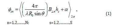
being s is the pixel locus in the TanDEM-X data, n is deliberated the interferogram band, λ is TanDEM-X wavelength, 0 R is the stretch between the epicenter of the sight and the controlling antenna, n B⊥ is the orthogonal baseline, s h is height rate in meter, α is the phase decorrelation noise, and an incident angle is presented by θ . Moreover, 2 . π signifies the “modulo - 2π ”. Let us assume that N is autonomous interferogram bands, thenceforth, the obstruction contains the retrieving of the sea level height rates , which is being from the S x N as a function of the expected wrapped phase sn φ . Succeeding Ferraiuolo et al. [7], the obstruction of demonstrating height can be elucidated by means of a MAP height approximation technique. In this understanding, the multichannel probability function mc F is formulated as:
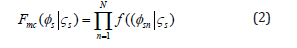
here F(φsn|ςs) is the likelihood function of the signal channel, φs is calculated wrapped phase data which is denoted the pixel s, φs= [φs1,φs2,.......,φsn]T,and ςs is collected vector height values where ς = [ς1,ς2,.......,ςs ]T S ς ς ς ς . Succeeding Baselice et al., [6] and Ferraiuolo et al. [7], a MAP algorithm height approximation can be casted by
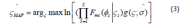
here g(.) is a preceding probability density function (pdf) which is approved by means of Gaussian Markov Random Field (GMRF)and ^σ is the hyperparameter route which is not a preceding identified. As said by Baselice et al., [6], GMRF can be appraised beginning from the restrained interferograms. This is realized by deliberating sub-bands, equivalent to diverse azimuth looks. In this regard, GMRF is determined by:
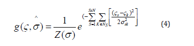
where Ns is the district system of sth pixel, and s is well known as hyperparameters, which are illustrative of the confined physical appearance of the sea level height h, σ is the hyperparameter vector assembling all pixel values, and Z(σ ) is the detachment function [8] which is required to standardize the pdf [6-8]. Lastly, the regularized restoration square error is estimated via:
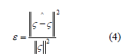
being ς is sea level height which is derived from equation 3 and the accurate height then can be estimated from equation 4 ^(ς ). Though the reform, deliberating the restricted sum of accessible data (four bands), is virtuous to recover its feature, predominantly on the disjointedness. Formerly, the inverse algorithm is executed to repossess the sea surface current pattern.
Data Set
Two panaches of acquaintance are required to inverse the sea surface current pattern which are:
a) TanDEM-X of SAR
b) Real in situ measurements throughout TanDEM-X satellite overpassed.
Satellite TanDEM-X Data
Pair of Terra-SAR satellite data is attained by the TanDEM-X satellite on May 6th, 2017. The earliest data was attained at 7:27:17 am, however, the subsequent data obtained at 19:20:06 pm. Both data are in spotlight mode with X-band and HH and VV polarization, respectively. Both spotlight mode is formatted in single look complex binary data. The TanDEM-X functioning concern encompasses the synchronized maneuver of 2 satellites hovering in the contiguous pattern.
The Modification Restraints for the Construction are:
a) The revolutions arising nodes
b) The perspective between the perigees
c) The revolution peculiarities
d) The phasing between the satellites.
The adherence of ocean surface flow is a vigorous façade of evaluating climate variations. Spaceborne SAR along-track interferometry (ATI) obligates the talent to greatly subsidize to the contemporary field. It will recommend a great-area, global -widespread seeming surface flow quantities. The difficulties of representing comparatively low-slung speeds are regularly resolute by developments of SAR satellites that produce satisfactorily considerate ATI quantities [4].
In this revision, the multichannel MAP height estimator relies on the TanDEMX facts. Both TerraSAR-X and TanDEM-X satellites transmit identical SAR devices functioning at 9.65 GHz frequency (X-band). All over approximately dedicated maneuvers, both satellites are positioned acquaintance exceptionally in an actual singular track confirmation through a fleeting along path reference line delivering a possibility for sea surface flow quantities. The TanDEM-X data exploited in this investigation were bistatic (TS-X active / TD-X passive) channel with VV polarization and in stripmap (SM) [3,4].
In situ Ocean Current Measurement
Succeeding Marghany [9,10], the device of Aquadopp® 2MHz current meter was used to acquire the physical information of sea surface flows, for instance, speed and direction (Figure 1). In this view, the surface flow information achievement was collected by the Aquadopp® 2MHz current meter factory-made by Nortek AS, Scandinavian country. The device could be a stand-alone composition manipulation the Doppler established frequently equipment to gauge the surface current flows at the positioning a fixed geographical location on the sea surface. The equipment is envisioned with basically memory and internal battery pack somewhere it may be intended to tape and collect information within for self-positioning [10].
Figure 1: Deployment of Aquadopp 2Mhz current meter in the coastal water.

Along the coastal water of Teluk Kemang, Port Dickson, Malaysia, the current meter instrument of Aquadopp® 2MHz current meter was arrayed on May 6th, 2017 (Figure 2).
Figure 2: In situ measurements geographical location.

Two periods of data collection were carried out:
a) At 6:15 am to 8:15 am
b) At 6:15 pm to 8:15 pm. During both phases, therefore, the surface flows were deliberated for intermissions of 2 hours.
Results and Discussions
The TanDEM-X satellite data with the spotlight of VV polarization are implemented to retrieve the sea surface flow rates. The retrieving sea level and sea surface flow variations are constrained to range direction. In fact, the sea surface current is only sensed along the range while the wave spectra information is a function of SAR azimuth direction. The retrieving sea surface flows are delivered inshore zone of the coastal water of the Teluk Kemang, Port Dickson, as part of the Malacca Straits. Therefore, the Doppler shift frequency of the ATI indicates fluctuations of sea surface flow. The inshore water has weak flow along 5 km of the coastal water. This indicates by lower rate value of 0.1m/s. In this regard, the lowest spectra peak of the Doppler frequency shift is 0.04 which is corresponding to the frequency shift value of -200 Hz (Figure 3). In this view, the weak inshore water flow could be attributed to the impact of the low tide of 0.3 m as noticed along the coastal water of the Teluk Kemang, Port Dickson.
Figure 3: TanDAM-X data Doppler Spectra Intensity.

Figure 4: The pattern of Interferogram phase.

The Interferogram phase is ranged between -0.7° to +0.7° (Figure 4) derived by multichannel MAP height estimator. Obviously, some pattern is visible. This pattern signature represents current feature variations along the coastal waters. Conversely, this interferogram phase is dominated by noises. The invert of the interferogram phase can use to compute the ATI Doppler sea surface current. The ATI Doppler shows a clear current pattern movement along the coastal waters with minimum and the maximum speed of 0.1m/sec and 0.2m/sec, correspondingly (Figure 5). In fact, an interferometric combination of the two images reveals phase alterations that are comparative to the backscatter variations of Doppler frequency shift [4]. This rapidity is conforming to sea level differences of 0.4m (Figure 5).
Figure 5: Sea surface current and sea level variations retrieved using an ATI MAP algorithm

Figure 6: Validation of MAP algorithm with in-situ measurement.

Figure 6 exhibits noteworthy correspondences between the consequence of sea surface flow speeds which created from TanDEM-X satellite data and the consequence delivered in the in-situ quantity. Figure 6 demonstrates how the correlation coefficient alteration as the direct correlation between the two different parameters which is modified. Whereas the deterioration of the emphasis is on forecasting single mutable from the other, in correlation the accent is on the grade to which a true model can designate the connection between two different measured parameters. Obviously, there is a worthy correlation between the retrieved sea surface flow and real in situ measured flow with R² of 0.76. Conversely, this correlation is not faultless, but it appears to have a confident direct association and resembles what one would guess when bearing in mind both sea surface flow simulations from satellite data and one is measured in-situ and then follow the hypothesis of normality.
As said by Romeiser et al. [3,4] the signatures of the Doppler frequency shift are clearly responsive to sea surface flow than to wind modifications. Similarly, a modification of the Doppler frequency shifts has a tinny effect on the TanDEM-X backscatter intensity as compared to the relaxation rate. Obtaining phase by using multichannel MAP height estimator algorithm will allow us to characterize the water sea level fluctuations. Three–dimensional reconstruction of water level changes from ATInSAR technique by using the algorithm of multichannel MAP height approximation can aid to regulate the vertical shift of sea level changes. Moreover, the multichannel MAP height approximation has achieved the difficulty of the phase unwrapping discontinuities and amended the vertical displacement synopsis as rivals to the conservative algorithm of phase unwrapping, for instance, (i) minimum-norm algorithm and (ii)path-following algorithm [6]. Lastly, TanDEM-X satellite data is comprehended as the prospective radar device for observing the dynamic fluctuation of the ocean surface [11-17]. Sea surface flow is considered as one of a consideration - impressing issue which is required a short visit cycle and extraordinary resolution. In this understanding, these can afford specifically facts in relation to sea surface dynamic flow [6-17].
Conclusion
This work has revealed a method for regaining sea surface flow using such high-resolution satellite data of TanDEM SAR-X. Alongtrack interferometry (ATI) technique is implemented to retrieve sea surface current movement. To this end, the multichannel MAP height estimator algorithm is prosecuted to model sea level variation. Then the inverse algorithm is used which based on the Doppler Frequency model to retrieve sea surface current. The results reveal that the sea surface flow pattern is dominated by a low velocity of less than 0.3 m/s which corresponding to lower sea level variation of 0.4 m. The study confirms that multichannel MAP height estimator algorithm is proficient to regain the sea surface flow rate from ATI TanDEM-X with an extraordinary precision of ±0.09 m/s. In conclusion, the approximation algorithm of multichannel MAP height conceivably can be a tremendous practice for repossessing sea surface flow pattern and sea level fluctuations from ATI TanDEM-X satellite data.
References
- Z Lu, Kim JW, Lee H, Shum C, Duan J, et al. (2009) Helmand river hydrologic studies using ALOS PALSAR InSAR and ENVISAT altimetry. Marine Geodesy 32(3): 320-333.
- DC Mason, Speck R, Devereux B, Schumann GJP, Neal JC, et al. (2010) Flood detection in urban areas using TerraSAR-X. IEEE Transactions on Geoscience and Remote Sensing 48(2): 882-894.
- R Romeiser, Runge H (2007) Theoretical evaluation of several possible along-track InSAR modes of TerraSAR-X for ocean current measurements. IEEE Transactions on Geoscience and Remote Sensing 45(1): 21-35.
- R Romeiser, Runge H, Suchandt S, Kahle R, Rossi C, et al. (2014) Quality assessment of surface current fields from TerraSAR-X and TanDEM-X along-track interferometry and Doppler centroid analysis. IEEE Transactions on Geoscience and Remote Sensing 51(5): 2759-2772.
- GW Yoon, Kim SW, Lee YW, Won JS (2013) Measurement of the water level in reservoirs from TerraSAR-X SAR interferometry and amplitude images. Remote sensing letters 4(5): 446-454.
- F Baselice, Ferraioli G, Pascazio V (2009) DEM reconstruction in layover areas from SAR and auxiliary input data. IEEE Geoscience and Remote Sensing Letters 6(2): 253-257.
- G Ferraiuolo, Meglio F, Pascazio V, Schirinzi G (2009) DEM reconstruction accuracy in multichannel SAR interferometry. IEEE Transactions on Geoscience and Remote Sensing. 47(1): 191-201.
- G Ferraiuolo, Pascazio V, Schirinzi G (2004) Maximum a posteriori estimation of height profiles in InSAR imaging. IEEE Geoscience and Remote Sensing Letters 1(2): 66-70.
- M Marghany (2011) Three-dimensional visualisation of coastal geomorphology using fuzzy B-spline of dinsar technique. International Journal of Physical Sciences 6(30): 6967-6971.
- M Marghany (2011) Developing robust model for retrieving sea surface current from RADARSAT-1 SAR satellite data. International Journal of Physical Sciences 6(29): 6630-6637.
- M Marghany (2012) Three-dimensional coastal geomorphology deformation modelling using differential synthetic aperture interferometry. Zeitschrift fur Naturforschung A-Journal of Physical Sciences 67(6): 419-420.
- M Marghany (2012) DEM reconstruction of coastal geomorphology from DINSAR. International Conference on Computational Science and Its Applications 435-446.
- M Marghany (2013) DInSAR technique for three-dimensional coastal spit simulation from radarsat-1 fine mode data. Acta Geophysica 61(2): 478-493.
- M Marghany (2014) Simulation of Tsunami Impact on Sea Surface Salinity along Banda Aceh Coastal Waters, Indonesia.
- M Marghany (2014) Hybrid Genetic Algorithm of Interferometric Synthetic Aperture Radar for Three-Dimensional Coastal Deformation. Hybrid Genetic Algorithm of Interferometric Synthetic Aperture Radar for Three-Dimensional Coastal Deformation 116-131.
- M Marghany (2015) Simulation sea surface current from RADARSAT-2 SAR data using Hopfield neural network. 2015 IEEE 5th Asia-Pacific Conference on Synthetic Aperture Radar (APSAR) 805-808.
- M Marghany (2019) Introductory Chapter: Advanced Ocean Current Simulation from TanDEM Satellite Data. Advanced Remote Sensing Technology for Synthetic Aperture Radar Applications, Tsunami Disasters, and Infrastructure.


-

Mark E Smith
Bio chemistry
University of Texas Medical Branch, USA -

Lawrence A Presley
Department of Criminal Justice
Liberty University, USA -

Thomas W Miller
Department of Psychiatry
University of Kentucky, USA -

Gjumrakch Aliev
Department of Medicine
Gally International Biomedical Research & Consulting LLC, USA -

Christopher Bryant
Department of Urbanisation and Agricultural
Montreal university, USA -

Robert William Frare
Oral & Maxillofacial Pathology
New York University, USA -

Rudolph Modesto Navari
Gastroenterology and Hepatology
University of Alabama, UK -

Andrew Hague
Department of Medicine
Universities of Bradford, UK -

George Gregory Buttigieg
Maltese College of Obstetrics and Gynaecology, Europe -

Chen-Hsiung Yeh
Oncology
Circulogene Theranostics, England -
.png)
Emilio Bucio-Carrillo
Radiation Chemistry
National University of Mexico, USA -
.jpg)
Casey J Grenier
Analytical Chemistry
Wentworth Institute of Technology, USA -

Hany Atalah
Minimally Invasive Surgery
Mercer University school of Medicine, USA -

Abu-Hussein Muhamad
Pediatric Dentistry
University of Athens , Greece
