Lupine Publishers Group
Lupine Publishers
Menu
ISSN: 2641-6794
Research Article2641-6794 
Geomorphology of Badland in Golbaf Playa, SE Iran Volume 4 - Issue 5
Somayeh Zahabnazouri*
- College of Geography, University of Tehran, Iran
Received: February 17, 2020; Published: March 09, 2020
Corresponding author: Somayeh Zahabnazouri, College of Geography, University of Tehran, Iran
DOI: 10.32474/OAJESS.2020.04.000196
Abstract
This paper deals with piping and badland geomorphology in the presently eroding playa of south Golbaf depression. The playa
surface which displays badlands features slopes gently towards the north and is about 105 km in length and its average width is
about 2km. Piping badland have progressively been evolved from the north towards the south. To study morphological variations,
three sites were selected. In every site the diameters and depths of 61 depressions and their ratio.
If the studied playa is divided into almost five equal parts from south to north, the southernmost part (part1) is almost flat
with negligible roughness. Towards the north, on the second part, the playa surface is very gently sloping with ~ 0.5 m relief and is
eroded by some gullies up to ~2m. The third part which contains small funnel-shaped depressions shows a relief of ~1m on playa
surfaces and is eroded by ~5m deeping gullies. The relief increases on the fourth part up to ~2m and gullies are up to 10m in depth.
In the northernmost part, surface relief is about 5 m and gullies are up to 20m in depth. The calculated ratios of average depths
to average diameters for sites A, B and C are 1.36, 1.45 and 1.78 respectively, indicating gradual increasing, as well as increasing
relationship between diameter and depth of depression by increasing in their size from site A toward site C.
Keywords: Badland; Piping; Geomorphology; Golbaf
Introduction
Badlands are miniature erosional landscapes comprised of
several types of landforms formed by a complex combination
of processes and customarily associated with arid and semiarid
environments (Warren, 1984). The dramatic character of
badlands, exhibiting clear morphological relationships which
result from the interaction of geomorphic processes with highly
erodible materials, has long stimulated geomorphic speculation
and investigation [1]. Vegetation cover on badlands is sparse.
Slopes are dissected by a dense drainage network within v-shaped
valleys [2]. Badlands exemplify structural and lithological control
at all scales and because the buffering effects of vegetation cover
are absent, lithological differences in them are often minutely
defined by weathering and erosion [1]. However, the requirements
of badland occurrence include erodible rock and available relief.
The main factor controlling badland formation is the character of
the bedrock. Usually, a protective caprock has been removed and
a softer rock less resistant to erosion surfaces. Tectonics and uplift
are sometimes involved in this process but also land use changes
may trigger the formation of badlands [3]. A working session of
the 1997 12th International Congress of Speleology concluded that
“pseudokarsts are landscapes with morphologies resembling karst,
and/or may have a predominance of subsurface drainage through
conduit-type voids, but lack the element of long-term evolution by
solution and physical erosion” [4]. Pseudokarst is considered to
mean karst-like landforms that have formed through processes that
are not dominated by solutional weathering or solution-included
subsidence and collapse [5]. They are similar to ordinary karsts in
terms of shape and general configuration and their characteristic
features are closed depressions and integrated underground
drainage comprised of pipes and tunnels [6]. Thus, they resemble
doline karsts, but in miniature scales [1].
There are several types of pseudokarsts which are introduced by
Grimes [5,7]. One type of them is formed in soil and unconsolidated
sediments and two main features of it include pipes and surficial
depressions [8]. This type is entitled as “badland pseudokarst”, also
known as surficial pseudokarst [6]. They are erosion landforms
characterized by gullying and piping as the major mechanisms of
development [1]. Other types have been identified in glaciers [9]
in permafrost areas [8], in volcanic terrains Halliday [7], and in
avalanche deposits and talus [7]. Crevices may be accompanied with caves. Hence, some authors consider them as crevice pseudokarst.
However, the key process in the majority of pseudokarsts is piping,
this explains why Parker [10] believe that pseudokarst term is
applied to the piped landscape. Badland pseudokarsts not only have
been rarely investigated, but also their conditions of occurrence and
evolution have not been well defined. Also, most badland research
has concentrated on geomorphic processes and few attempts have
been made to study longer term badland evolution [1].
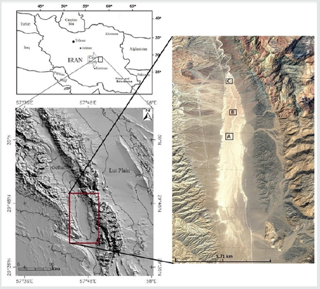
In south Golbaf playa (Figure 1), badland pseudokarsts have
progressively been evolved from the north towards the south,
so that all gradations from initial features to well-developed and
large collapse depressions and gullies are present. That is, this
area provides an ideal opportunity to study creation and evolution
of these badlands. The goal of the present study is, therefore, to
introduce these badlands and investigate their development.
Materials and methods
Field measurements
To study morphological variations, three sites were selected, (sites A, B and C). In every site the diameters and depths of 61 depressions. Depressions are not usually quite circular in plan. To tackle this problem, firstly, the maximum diameter of each depression was measured. Afterwards, the diameter at right angle to maximum diameter was determined. Finally, the average of these two measurements was considered as the diameter of each depression. This is the usual practice in morphometrical studies of dolines in true karsts [11].
'Data analysis
Using SPSS software, morphometric parameters of depressions were statistically analyzed, and the resulted parameters were compared. Additionally, the relationships among morphometric variables were investigated.
Results
Study area
The south Golbaf playa lies at 57°, 46’ to 57°, 47’ eastern
longitude and 29°, 43’ to 29°, 48’ northern latitude in SE Iran. It, s
elevation ranges from 1752m at south to 1730m at north. Having a
length of 9.1 km and an average width of 1.7 km, it is considered as
a small elongate playa (Fig 1). This playa is situated at the southern
part of Golbaf tectonic valley which trends NNW-SSE. This valley
is bounded from the west by Sekonj Mountain with a height of up
to 4200 m and from the east, by Abbarik Mountain which reaches
2700 m in height. The elevation of Golbaf valley varies from about
1700 m to about 2000m. The average annual precipitation and temperature in south Golbaf playa are about 110 mm and 17 °C
respectively, indicating a dry climate. Precipitation mainly occurs
in winter and the driest season is summer with negligible amounts
of rainfall.
The mainstream course which drains the area towards the
north lies amid the playa. It is 20-100m in width. Its depth varies
from negligible amounts at south to about 25m at north, indicating
the amounts of incision. In the northern part of playa, all branches
joining the main course from eastern and western bahadas have
carved gullies in playa deposits. The mainstream leaves the playa
at an overflowing point which is located about 2 km at northward
limit of playa. The sekonj mountain consists of Jurassic siltstones
and sandstones and the Abbarik mountain is mainly comprised of
Cretaceous sedimentary rocks which trust over Eocene volcanic
and Paleogene pyroclastics [12]. The Golbaf valley is covered with
Quaternary alluvial deposits (alluvial fan gravels and playa muds).
The south Golbaf playa lies on the Gowk section of Nayband fault
system. This right- lateral system accommodates the shear between
central Iran in the west and Lut block in the east. Geomorphic
features, as well as, the occurrence of three Ms >6 earthquakes in
the last 35 years indicate that it is a very active fault system [13]. The
Gowk fault, with a strike of about 155°, lies in a compressive bend
amid the Nayband fault system which has a general strike of about
175°. The Golbaf valley exists as a topographic low because of the
small up-to-east normal component of Gowk fault [12]. However,
Berbarian, [14] suggest that the overall cross-sectional structure
of Gowk fault system is a ramp- and- flat trust with superimposed
strike-slip motion. This component of motion largely determines
the longitudinal evolution of this valley and the structure at depth is
reflected mainly in the vertical motions at the surface [12].
Golbaf tectonic valley is 2-4 km in width and there are a series
of depressions along it which are commonly separated by alluvial
fans. The south Golbaf playa in which badland pseudokarsts have
formed is one of these depressions that has received sands, silts and
clays from the arriving ephemeral streams. This playa occupies a
pull-apart position in a right- step between two major segments of
Gowk fault, and is filled with playa deposits that are incised by a
through- going longitudinal stream and its tributaries [15].
The studied area is part of a bahada- playa- mountain unit
which is a characteristic feature of arid zones. The mountainbahada
border is rather straight and is comprised of active faults.
On average, bahadas bordering this playa are about 1.7 km in
width and consist of many alluvial fans. Due to high topographic
gradients, the mountains contain sharp crests and high drainage
densities [16]. There is a 1-3m erosional scarp between playa
surface and the bordering bahada which faces towards the bahada.
This scarp is created by erosion of sandy skirt encircling the playa,
i.e., the playa surface is higher than the surrounding bahada. Thus,
it is considered as an inverted relief. Also, there is a north-south
trending young normal fault at the western part of playa near its
border with bahada with an escarpment facing east. Its influence
on badlands is only limited to its scarp surface. The rather straight
western border of this playa is mainly controlled by this active fault
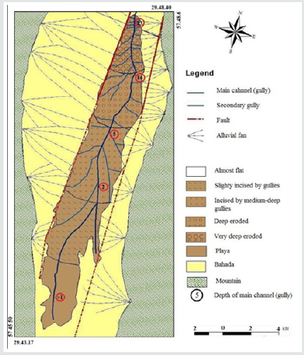
(Figure 2).
Geomorphology
Depression: There are two types of depressions in the studied area. Depressions of the first type which consist the majority are funnel-shaped and circular to subcircular in plan. They usually contain a swallow hole at the bottom which carries the surface runoff into a vertical pipe. The diameter and depth of these types which increase northwards [17]. These depressions commonly occur in rows, following the original dehydration cracks. Surfaces containing these depressions show pitted topography reminiscent of doline karst. The other type of depressions is only observed in the northernmost part of the playa where badlands are more developed. These depressions have formed by collapse of enlarged horizontal pipes and are circular to elongate in plan, with vertical walls.
Gullies: Gullies are commonly an integral part and one of the most common features in the majority of badlands. Although gullies are less frequent in the studied area, they play an important role in its evolution. Originally, there are two types of gullies in the studied area. Gullies of the first type are both large and long and originate from the erosion of playa surface as a result of Knick point recession and incision by streams flowing from bahada [18]. These are box-shaped in section and have played a major role in the creation of these badlands by forming dehydration fissures through draining the mudrocks and generating hydraulic head for the action of pipe system. The second type gullies are only observed at the northern limit of the studied area and have shaped by roof collapse of enlarged horizontal pipes. These gullies are commonly irregular in shape and may contain bridges and collapse debris along their courses.
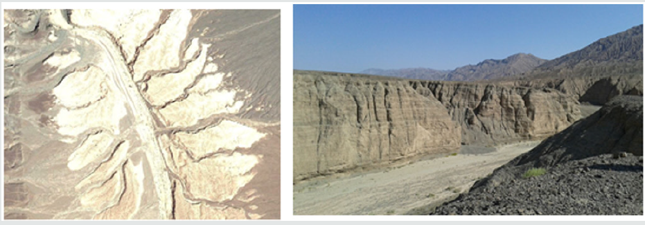
Relief: If the studied playa is divided into almost five equal parts from south to north (Figure 1), the southernmost part (part1) is almost flat with negligible roughness. Towards the north, on the second part, the playa surface is very gently sloping with ~ 0.5 m relief and is eroded by some gullies up to ~2m. The third part which contains small funnel-shaped depressions shows a relief of ~1m on playa surfaces and is eroded by ~5m deeping gullies. The relief increases on the fourth part up to ~2m and gullies are up to 10m in depth (Figure 3). In the northernmost part, surface relief is about 5 m and gullies are up to 20 m in depth (Figure 4). Consequently, both inter-gully surface relief and gully depths gradually increase towards the north.
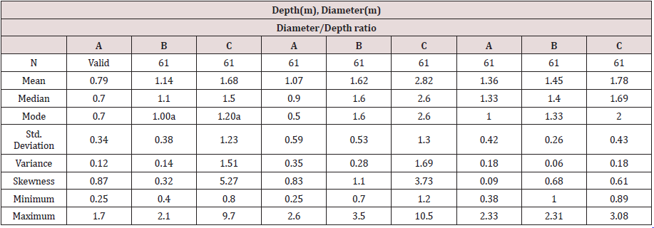
Morphometry
The statistics of diameters and depths of 61 depressions on each of measurement sites are presented in Table 1. The Relationship between morphometric parameters for diameter and depth values and ratios of average depths to average diameters are also given in Figure 5. Morphometric analysis indicates that funnelshaped depression grows in diameter, depth and surface area with the passage of time. Their surface slope angle with the passage of time, the diameter of horizontal and vertical pipes increases. As observed, the average diameters and depths of depressions increase northwards [19]. The calculated ratios of average depths to average diameters for sites A, B and C are 1.36, 1.45 and 1.78 respectively, indicating gradual increasing, as well as scatter diagram that shows increasing relationship between diameter and depth of depression by increasing in their size from site A toward site C (Figure 5).
Conclusion
Playa deposits are potentially conductive for development of badland because they usually are soft unconsolidated and porous, rich in silt fraction and contain expansive clays. However, at normal conditions, playa surfaces are flat and in depositional regime. Hence, their conditions must be changed into erosional regime by such agents as tectonic activity or, as in the case of studied area, by overflowing and creation of a Knick point downstream of overflowing point. Knick point retreat towards playa surface creates an erosional regime which in retrospect generates hydraulic gradient, gullies and, eventually, dehydration fissures. It seems that the occurrence of dehydration fissures in playa deposits sets the stage for the development of badland pseudokarsts. These badlands form by the appearance of pipes and erosion depressions. As a result of horizontal pipe roof collapse, they transform into a set of gullies and residual hills. Gradual erosion of hills by rain splash, surface erosion, rills and mass wasting will give rise to disappearance of badlands.
Both dry climate and lack of vegetation have influenced
badland development in this area. Dry climate has enhanced the
dehydration process and creation of fissures. Severe but slight rains
which are rather prevalent in this climate have not ample time to
soak the soil, but the resulting surficial flows enhance the creation
of mudflows which are a main agent of pipe erosion. In contrast,
slight but prolonged rains have ample time to soak the soil. Hence,
they are effective in triggering mass wasting and widening the
gullies.
Lack of vegetation has given rise to decreases in surface
permeability and infiltration due to the absence of surface litter and
organic matter. The lack of protection by vegetation has intensified
rain splash and other types of surface erosion.
It is worth to note that complexity of climate change and its
influences, and the effects of tectonics may be so important in
landform evolution. However, with respect to the studied area, the
relatively rapid evolution of the badlands means limited influence of
climate change on their development. Also, considering mudrocks
in the studied area are level and undisturbed by tectonic activity
(except in the western limit of playa), evidently the influences of
climate change and tectonic activity on evolution of these badlands
are limited.
References
- Campbell IA (1982) Surface morphology and rates of change during a ten-year period in the Alberta badlands. In Badland geomorphology and piping, Bryan R, YairA (Eds.), Geo Books, Norwich, UK, pp. 221-36.
- Bryan R, Yair A (1982) Badland Geomorphology and Piping. England, UK.
- Gallart F, Solé A, Puigdefábregas J, Lázaro R (2002) Badland Systems in the Mediterranean. In Bull L J, Kirkby MJ (Eds.), Dryland rivers: Hydrology and Geomorphology of Semi-arid Channels pp. 299-326.
- Kempe S, Halliday W (1997) Report of the discussion on pseudokarst. In Proceedings of the 12th International Congress of Speleology 6: 107.
- DoerrSh, Wray R (2004) Pseudokarst. In Goudie AS(edn), Encyclopidia of geomorphology 2: 814-816.
- White WB (1988) Geomorphology and Hydrology of Karst Terrains, Oxford and Oxford University Press, New York, USA.
- Halliday WR (2007) Pseudokarst in the 21st century Journal of Cave and Karst Studies. 69: 103-113.
- Otvos E,Otvos JR (1976) “Pseudokarst” and “pseudokarstic terrains”: Problems of terminology. Geological Society of America Bulletin 87:1021-22.
- Fountain A, Wilder J (1998) Water flow through temperate glaciers. Reviews of Geophysics 36(3): 299-328.
- Parker G (1990) Piping and pseudokarst in drylands. In Groundwater Geomorphology: The Role of Subsurface Water in Earth-Surface Processes and Landforms, edited by Higgins CG & Coates DR, Boulder, Geological Society of America, Colorado, USA.
- Ford DC, Williams PW (1989) Karst Geomorphology and Hydrology, Unwin Hyman, London and Boston, UK.
- Dimitrijevic MD (1973) Geology of Kerman Region. Geology Survey of Iran Report No. 52: P.334.
- Walker Jackson (2002) offset and evolution of the Gowk fault, Iran SE. A major intra-continental strike-slip system:Journal of Structural Geology 24: 1677-1688.
- Berberian M (1984) Structural evolution and tectonics of the Iranian plateau, a plate tectonic approach, Bogdanov NA, Tesizy, 27-Ymezhdunarodnyy geologicheskiy congress, Abstracts In: 27th international Geological Congress 27(3): 140.
- Halliday WR (2004) Pseudokarst. In: Gunn J (edn), Encyclopedia of Caves and Karst Science. New York and London: Fitzroy Dearborn 604-608.
- Howard AD, Kerby G (1983) Channel changes in badlands. Bulletin of the Geological Society of America 94: 739-52.
- Howard AD (1994) Badlands In: Abrahams AD, Parsons AJ (Eds.), Geomorphology of Desert Environments. Chapman and Hall, London, UK, pp. 213-242.
- Poesen J, Nachtergaele J, Verstraeten G, Valentin C (2003) Gully erosion and environmental change: importance and research needs. Catena 50: 91-133.
- Sirvent J, Desir G, Gutierrez M, Sancho C, Benito G (1997) Erosion rates in badland areas recorded by collectors, erosion pins and profilometer techniques (Ebro Basin, NE-Spain). Geomorphology 18: 61-75.

Top Editors
-

Mark E Smith
Bio chemistry
University of Texas Medical Branch, USA -

Lawrence A Presley
Department of Criminal Justice
Liberty University, USA -

Thomas W Miller
Department of Psychiatry
University of Kentucky, USA -

Gjumrakch Aliev
Department of Medicine
Gally International Biomedical Research & Consulting LLC, USA -

Christopher Bryant
Department of Urbanisation and Agricultural
Montreal university, USA -

Robert William Frare
Oral & Maxillofacial Pathology
New York University, USA -

Rudolph Modesto Navari
Gastroenterology and Hepatology
University of Alabama, UK -

Andrew Hague
Department of Medicine
Universities of Bradford, UK -

George Gregory Buttigieg
Maltese College of Obstetrics and Gynaecology, Europe -

Chen-Hsiung Yeh
Oncology
Circulogene Theranostics, England -
.png)
Emilio Bucio-Carrillo
Radiation Chemistry
National University of Mexico, USA -
.jpg)
Casey J Grenier
Analytical Chemistry
Wentworth Institute of Technology, USA -
Hany Atalah
Minimally Invasive Surgery
Mercer University school of Medicine, USA -

Abu-Hussein Muhamad
Pediatric Dentistry
University of Athens , Greece

The annual scholar awards from Lupine Publishers honor a selected number Read More...


