Lupine Publishers Group
Lupine Publishers
Menu
ISSN: 2641-6794
Research Article2641-6794 
Huge Inundation (March 2019) of Golestan Province, Iran, Lessons that We Learned Volume 4 - Issue 3
Mohammadreza Gharibreza*
- Soil Conservation and Watershed Management Research Institute, Agricultural Research, Education and Extension Organization (AREEO), Iran
Received: November 22, 2019; Published: December 16, 2019
Corresponding author: Mohammadreza Gharibreza, Soil Conservation and Watershed Management Research Institute, Agricultural Research, Education and Extension Organization (AREEO), Iran
DOI: 10.32474/OAJESS.2019.04.000188
Abstract
Gorgan Province is in the North-East of Iran and the East of the Caspian Sea. Climate change as essential driving force and high elevation the east Alborz range (≈ 3,000 m) created situation, which half or one-third of annual precipitation have rained during few days. Therefore, many destructive flash floods and extensive inundation have been happened since the last two decades. The latest huge inundation has occurred in March 27, 2019, when about 2.2 BCM volume of rainfall has been received especially at the East of Agh-Ghala city. An area with 50km in width and 170km length has covered by different thickness of water columns. Present research suggested series of management practices before, during and after flood events that should be considered for high-risk areas such as the Golestan Province. Several key lessons that have been achieved, implies to management practices to well identify issue and control and mitigate risk of flood and to canalize excess water into the natural depressions and the coastal areas. In addition, this huge event highlighted setting of volunteers and sacrificing activities to conquer on mental damages of people who are lining in flooded areas. Decision makers and academics that are involving similar condition of flood risk could apply such lessons to overcome impacts of inundation around the world.
Introduction
More than 75% of Iran territory has arid and semi-arid weather and climate change has been appeared in destructive flash floods and inundation of lowlands. Golestan Province that is extended in the North-East of Iran, experienced 133 flash floods and inundation events since 1991 [1]. The worst and destructive floods has happened in August 10, 2001 in which 500 people have dead and countless physical and mental damages in different aspects have been received to the Golestan Province. The latest huge flood has happened in March 27, 2019, which resulted in an extensive inundation of lowlands. This event was the real evidence of climate change and its impacts increased because of anthropogenic changes that made since the last decades. Literature review showed that flood hazards of the Golestan Province have been studied with emphasize on flood simulations and application of prediction models and remote sensing [1,2-9]. The gap in previous works was detected in management of floods and inundations especially in interaction between lowlands and the Caspian Sea. The research objective was finding out the mechanism of flood happening and relevant management practices and to introduce achievements for facing to similar condition in future in the study area and around the world.
Materials and Methods
The study area
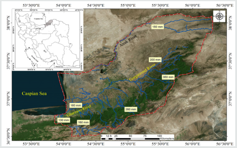
The Golestan Province with 22,000 km2 distribution is located at the North-East of Iran and the East of the Caspian Sea. Three major rivers of the Gorganroud, Gharesoo and Atrak with specific watersheds are draining in the study area. These watersheds have two mountainous (9500 km2) and lowlands (12,500 km2) morphological features which have experienced flash floods or inundation events depends on focal points of such events. The highest and lowest altitude are 2898 m and -28 m along the East of Caspian Sea shorelines. The annual rainfall varies between 200 mm and 1000 mm with decreasing west to east trend. The main land use belongs to agriculture (37 %), while rangelands and Hircanian Forest have occupied 34 %, and 28 % of the study area, respectively (Figure 1).
Figure 1: Geographical position of the Golestan Province and rainfall data during huge inundation March 27, 2019.

Data collection and analysis
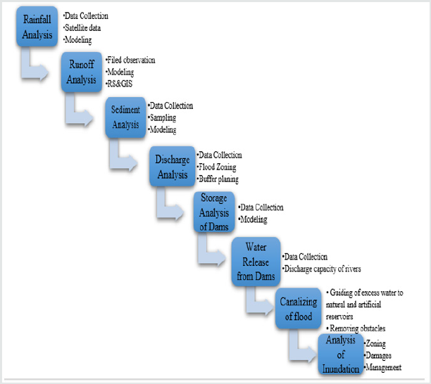
Data collection included raw and analyzed information of rainfall and river discharge of the Gorganroud, Gharesoo and Atrak rivers were collected from the Meteorological Organization and the Regional Water Company of the Golestan Province, respectively. In addition, comprehensive field observations and technical meetings with main local stockholders’ teams that were involved in management of event have supported the analyses. Data collection and analysis has been implemented based on following conceptual model (Figure 2). Accordingly, inundation analysis was started by analysis of rainfall, runoff, water and sediment volumes, storage and effectiveness of dams, release of water from dams, and canalizing and guidance of excess water.
Results and Discussion
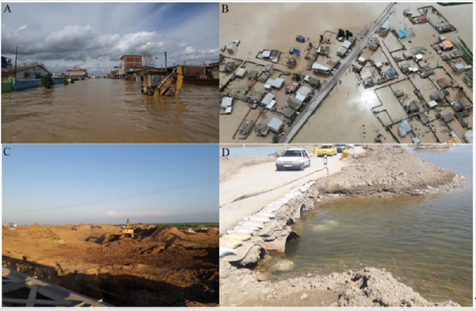
Watershed of the Gorganroud and Gharesoo rivers have received the rainfall with the range between 74 mm and 353mm within 5 days. The main stage of huge inundation was happened in Gorganroud River catchment when about 2.2 BCM of rainfall has been received especially at the East of Agh-Ghala city [10]. Estimations show that flood front with 666 MCM volume has been passed from Voshmgir Dam and moved to Agh-Ghala city at center of low land area with discharge of 120 m3s-1. Real feature of huge inundation was appeared when it covered 50 km in width and 170 km along the Gorganrud River. In total, four cities of Gonbad, Agh-Ghala, Anbar-Aloum, Gomishan and 82 villages with 695,000 people have surrounded deeply by flood. Urban and rural areas which were located near the natural depressions have been inaccessible at all (Figure 3). Evidences showed that dams those constructed in hilly areas of the study area played role as retention reservoir and have not effectiveness in terms of flood control, it was the first lesson that we learned. The second Lesson was that land development projects like railways and highways which have carried out vertical to coastal plain and rivers were major obstacles and have increased water-level and intense of inundation. Rescuing facilities should be predicted according to historical potential of floods and inundations. Filed observations showed that most of villages have been built on hills that implies to precautions which have considered by ancient people. Therefore, the third lesson was regarding to local knowledge in terms of land development. Canalizing of excess water into the natural depressions was the fourth lesson that implemented by military forces using heavy machinery (Figure 3). There are five natural depressions in the coastal plain of the Caspian Sea with five MCM capacity that have been used to push excess water volumes. Although, this practice was carried out relatively too late, but played important role in drainage of water from flood plain. Dredging of river channels as the fifth lesson was implemented along the Gorganroud and Gharesso Rivers to increase capacity for draining of flood toward coastal zone. The biggest problem that caused low rate of draining of water was very low depth of Gorganroud River Delta and the Caspian Sea wave regime that limited discharge of water and sediment. Accordingly, the latest practice on river channel was dredging of two km of the river delta. Increasing of deltaic distributaries channels capacity was the sixth lesson for management of flood and inundation events in coastal areas.
Figure 3: Showing inundation of A) Urban area, B) Rural area, C) canalizing of excess water, and D) Increasing of waterways in cutting roads.

Providing of immune infrastructures and places based on population of flooded areas is necessary practice to compensate mental damages of flood. This practice was the seventh lesson that was implemented successfully by volunteers and other authorized groups of people. Sacrificing of living facilities by Iranian people and some few countries played important role in recreation of flooded areas. Reconstruction of damaged buildings and infrastructure was started immediately after draining of excess water by governmental agencies with aid of volunteer’s forces was vital practice. Therefore, the last lesson that we learned was rapid reconstruction plan of flooded area. Providing condition for rapid coming back of students to schools and universities and returning of laborers to the factories and farms and families to their homes was a necessary management practice that was carried out in the flooded areas.
Conclusion
Climate change is the main driving force in the study area in terms of happening flash floods and consequent inundation. Deforestation and land use changes as on-site driving forces have accelerated runoff and happening of floods. In addition, we found that watershed management practices in mountainous areas of the study area have been not adequate to control and mitigate generation of floods. In fact, these practices cannot effective when half (500 mm) or one-third (350 mm) of annual rainfall has received to small part of catchment in few days. Present research has concluded that series of before, during and after floods management practices should be considered for high risk areas such as the Golestan Province. Lessons that have achieved for identifying the issues and performing management practices during and after flood event have presented briefly. Decision makers and academics that are involving similar condition of flood risk could apply such lessons to conquer impacts of overflow around the world.
References
- SharifiF, Samadi S Z, Wilson C (2012) Causes and consequences of recent floods in the Golestan catchments and Caspian Sea regions of Iran. Nat Hazards 61:533-550.
- Arabameri A (2019)A comparison of statistical methods and multi-criteria decision making to map flood hazard susceptibility in Northern Iran. Science of The Total Environment660: 443-458.
- Chapi K (2017) A novel hybrid artificial intelligence approach for flood susceptibility assessment. Environmental Modelling & Software 95: 229-245.
- Choubin B (2019) An ensemble prediction of flood susceptibility using multivariate discriminant analysis, classification and regression trees, and support vector machines. Science of The Total Environment651:2087-2096.
- Darand M, PazhohF (2019) Synoptic analysis of sea level pressure patterns and Vertically Integrated Moisture Flux Convergence VIMFC during the occurrence of durable and pervasive rainfall in Iran. Dynamics of Atmospheres and Oceans86: 10-17.
- Falah F (2019) 14 - Artificial Neural Networks for Flood Susceptibility Mapping in Data-Scarce Urban Areas, in Spatial Modeling in GIS and R for Earth and Environmental Sciences, Pourghasemi HR, Gokceoglu C. EditorsElsevierpp. 323-336.
- Kanani-Sadat Y ( 2019)A new approach to flood susceptibility assessment in data-scarce and ungauged regions based on GIS-based hybrid multi criteria decision-making method. Journal of Hydrology572: 17-31.
- Shadmehri Toosi A ( 2019) River basin-scale flood hazard assessment using a modified multi-criteria decision analysis approach: A case study. Journal of Hydrology574:660-671.
- MosaffaieJ (2015) Comparison of two methods of regional flood frequency analysis by using L-moments. Water Resources42(3): 313-321.
- GZRW (1398) Story of Flood. Regional Water Company of Golestan: Gorgan, Iran, p. 1-30.

Top Editors
-

Mark E Smith
Bio chemistry
University of Texas Medical Branch, USA -

Lawrence A Presley
Department of Criminal Justice
Liberty University, USA -

Thomas W Miller
Department of Psychiatry
University of Kentucky, USA -

Gjumrakch Aliev
Department of Medicine
Gally International Biomedical Research & Consulting LLC, USA -

Christopher Bryant
Department of Urbanisation and Agricultural
Montreal university, USA -

Robert William Frare
Oral & Maxillofacial Pathology
New York University, USA -

Rudolph Modesto Navari
Gastroenterology and Hepatology
University of Alabama, UK -

Andrew Hague
Department of Medicine
Universities of Bradford, UK -

George Gregory Buttigieg
Maltese College of Obstetrics and Gynaecology, Europe -

Chen-Hsiung Yeh
Oncology
Circulogene Theranostics, England -
.png)
Emilio Bucio-Carrillo
Radiation Chemistry
National University of Mexico, USA -
.jpg)
Casey J Grenier
Analytical Chemistry
Wentworth Institute of Technology, USA -
Hany Atalah
Minimally Invasive Surgery
Mercer University school of Medicine, USA -

Abu-Hussein Muhamad
Pediatric Dentistry
University of Athens , Greece

The annual scholar awards from Lupine Publishers honor a selected number Read More...


