Lupine Publishers Group
Lupine Publishers
Menu
ISSN: 2641-6794
Case study2641-6794 
Characterization and Evaluation of Some Soils of Gode in Eastern Ethiopia as Affected by Salinity and Alkalinity induced by Irrigation Canal: A Case Study Volume 6 - Issue 1
Mahamed Badel Mahamed1 and Mishra BB2*
- 1Somali Region Pastoral and Agro-pastoral Research Institute, Ethiopia
- 2Former Professor, World Bank Project, Alemaya University, Ethiopia
Received: January 18, 2021 Published: January 28, 2021
Corresponding author: Mishra BB, Former Professor, World Bank Project, Alemaya University, Dire Dawa, Ethiopia
DOI: 10.32474/OAJESS.2021.06.000227
Abstract
West Gode area of the Somali region in the eastern Ethiopia has been traditionally addicted and ideally suitable for pastoralism with virtually very limited acreage under crops. The construction of irrigation canal in the west Gode for assured irrigation could have successfully changed the farming system towards crop production. However, the impact of irrigation water is now polluting the soils of the whole catchment leading to physical, chemical, and even biological degradation unless suitable managements are taken. Four representative profiles were studied for their morphological description and other relevant characterization in order to assess the degree and magnitude of the preferred land characteristics as well as qualities. The soils occurring near the main canal are getting more affected as compared to the soils away from the canal. However, the diversion channels in the catchment followed by frequent use of water for irrigation unscientifically are aggravating the severity of such problems almost throughout the study area. The soils were evaluated to be highly productive in their potential productivity, but the actual productivity is getting deteriorated at an alarming rate. The area has twin resource avenues for green as well as white revolutions. This calls for quick intervention of the federal government on priority basis in order to safeguard the problems at the initial stage of their emergence. The problem is directly related to the food insecurity of a large population in the catchment.
Keywords: West Gode; somali region; canal irrigation; salinity and alkalinity; productivity evaluation; problem identification; improvement suggested
Introduction
Ethiopia is known globally to have been gifted with highlands with altitudes varying between 1500 and 4500 m above MSL [1]. However, the Somali zone particularly the one falling in Gode area is low land (200-400 m altitude) of virtually tropical to subtropical climate, in which the major agricultural activities have been confined to pastoralism. Based on the first ever land cover survey by FAO (1984) for entire Somali National Regional State, Gode zone constitutes major grazing land of about 56 per cent of the total area. Woodland, shrubland and bushland constitute about 33 per cent of the total area of the zone. Only a limited area of about 0.3 per cent was identified as cropped land area until 1984 (FAO 1984). The area is known to have rich ground water resource, but the water quality is not safe. The irrigation canal has recently been constructed by the government of Ethiopia with its successful functioning in revolutionizing the planned crop cultivation program. Unfortunately, the over irrigation had caused soil salinity and alkalinity, which are damaging the soil health and quality of the catchment. In one hand, the canal through providing the assured irrigation has diverted the traditional mentality of the farming community towards intensive crop production approach, wherein, on the other hand, the adverse impact of irrigation water is deteriorating the soil productivity at an alarming rate. The present investigation, thus, aims at characterization of some representative soils being affected by the canal water and their productivity evaluation in order to identify the soil related constraints for improvement. In terms of any option for food security, the present investigation is of vital importance to be addressed as pre-requisite before implementing any production activity in the area.
Materials and Methods
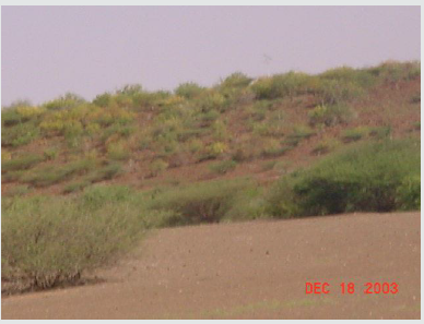
The Gode town about 45 km east of the study area lies between N 05o57.025’ latitude and E 43o33.033’ longitude at an altitude of around 300 m above MSL, whereas the study area lies with geographical positions of around N 05o58.889’/06o00.406’ latitudes and E 43o11.601’/43o12.093’ longitudes at the altitudes between 280 and 290 m above MSL. The geographical positions of irrigation canal at three points adjacent to the study sites are N05o58.856’/E 43o11.593’, N 06o00.789’/E43o09.275’ and N 05o56.818’/E 43o33.164’ (terminating point). Comparatively being close to equator with low altitude, this area suffers almost from tropical climate. The mean annual rainfall hardly exceeds 340 mm, whereas mean annual temperature is around 28.7oC (Table 1). The common rock species identified were sandstone, limestone, granite, and basalt, mostly with rounded or blunt edges, which was diagnostic to their fluvial deposition. The remnant of basalt was observed in the form of a distorted hill around Gode ( N 05o57.910’ latitude/E 43o28.894’ longitude) as shown in Figure 1 near the village Berddekorah (N 05o57.371’ latitude/E 43o20.884’ longitude) and Dabaldeg (N 05o57.159’ latitude/E 43o18.249’ longitude). Dense and green short grasses were observed growing around the study sites (N 05o57.542’ latitude/E 43o24.351’ longitude) even during dry season likely due to silt texture of the surface soils.
The main river (Wabi Shabelle) flowing south of irrigation canal has a diversion at N 05o57.331 latitude/E43o32.749’ longitude. The SoRPARI Agricultural Research Farm covers an area of 20 ha with four corners (N 05o58.889’/ E43o 11.601, N05o 58.712’/ E43o11.988’, N 05o58.813’/43o12.002’ and N 05o58.991’/ E43o11.520’) and situated just along the irrigation canal. The canal water was operationalized for actual irrigation only in the first part of 2003 (January), whereas SoRPARI Research Farm was started in April 2003. Altogether four profile sites were identified. Two were in two opposite corners of the SoRPARI research farm (Pedons 1 and 2), whereas other two (Pedons 3 and 4) were located at one and two km far away from the main irrigation canal, respectively along with the diversion channel. Accordingly, profile pits were exposed for morphological description. Soil samples were collected from each horizon for laboratory analysis following the standard procedures. The soil-site characteristics and existing land use were recorded during profile description. Based on relevant characteristics of soils, parametric method of productivity ratings for each pedon was employed following the procedures outlined by Riquier [2]. The degree and magnitude of each factor was evaluated for its deviation from the maximum rating. In productivity terms, limiting factors were identified and possible improvement to the limitation was worked out. Based on susceptibility of limitation to the applied improvement, index of all parameters was developed to assign as index of potentiality (IP), which implied the maximum level of productivity after improvement. The coefficient of improvement (CI) then defined as the ratio of the index of potentiality (IP) to the productivity index (PI). The CI values were further related to yield of crop and productivity thereof.
Results and Discussion
Farming system
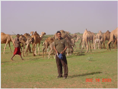
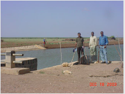
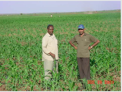
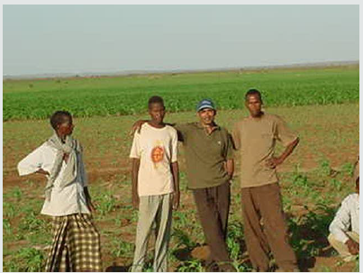
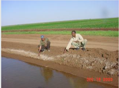
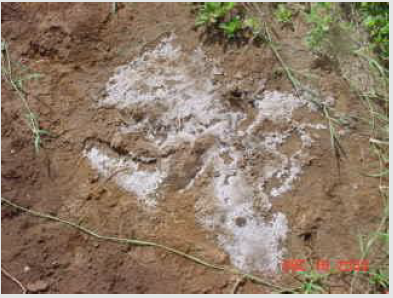
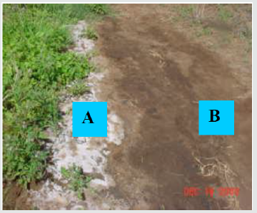
The area is typically adapted to livestock production (Figure 2) and farmers do accept such traditional way of farming. Figure 3 is just a token of farmer’s sincerity to their camels. The construction of irrigation canal (Figure 4) has been proved an asset to a changed scenario of farming system through crop production. The huge water capacity of this canal diverted the mind of farmers to start crop production with assured irrigation. This has led to the farmers to cultivate their land by applying irrigation (Figure 5). The cropped area (Figure 6) and farmer’s enthusiasm (Figure 7) to observe the cropped lands as token of green revolution are witness to the success of this irrigation canal. However, the dissolved salts present in the canal water have become an alarming threat to crop production. Figure 8 shows the salt encrustation on diversion channel after recession of canal water. The white patches of salt (A) through seepage appeared on the opposite part of the diversion channel, whereas black alkali is seen just in the adjoining flat plain land (B) as shown in Figure 9. Figure 10 indicated the varying degree and magnitude of salinization due to frequent irrigation at the SoRPARI research farm. Such salinization followed by alkalinization (black alkali) is now declining the crop performance and yield. Even the crop of rice, which is tolerant to salinity and alkalinity, is not performing well (Figure 11). The photographs thus indicate the severity of the problem because of salinity and alkalinity. Unless suitable measures are taken, this canal is becoming curse to future planning of agricultural production.
Figure 9: White salt encrustation on the back of the ridge of the diversion channel (A) and black alkali (B) on adjacent flat land of the research farm
Soil-site characteristics
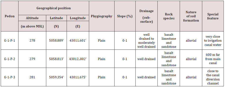
Pedons 1 and 2 were situated in the SoRPARI Research Farm and close to the main irrigation canal. Each plots of the farm is connected with the diversion channels for irrigation. The problem of salinity and alkalinity is now emerging, and the choice of crops is now being affected adversely, though systematic agronomic research is awaited. The whole study area was almost plain with 0-1 per cent slope (Table 2). Pedons 3 and 4 were situated out of the research farm in the north. The soils were well drained with alluvial origin. The rock species were mixed type including sandstone, limestone, and basalt. The role of topography and climate was almost constant throughout the study area. Even the parent materials were identical throughout the study sites (Table 2). However, pedons 3 and 4 were more fine in texture as compared to Pedons 1 and 2. This indicates that Pedons 1 and 2 were developed more actively by fluvial actions as compared to Pedons 3 and 4. The water table was not high although the canal and water use frequency is rapid and injudicious for irrigation. Sometimes, there is overflow also from the diversion channels.
Morphological features
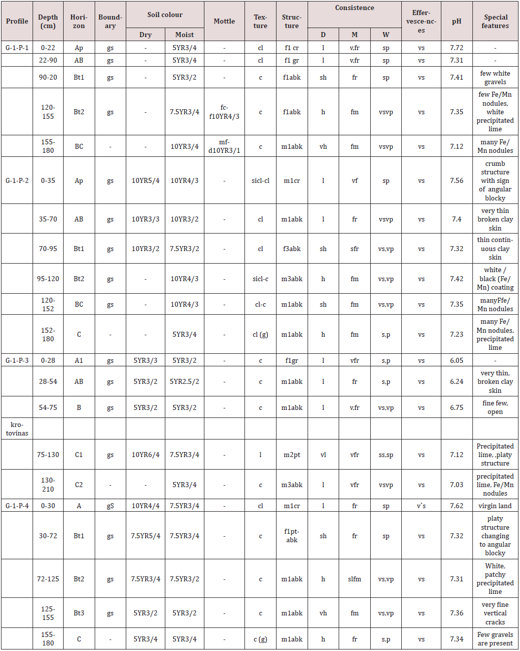
Morphological features of the soils in different four pedons are presented in Table 3. The Research Farm soils were lighter in texture (Pedons 1 and 2) as compared to the soils of Pedons 3 and 4. However, they were almost clayey in textural make-up. The colour change among the pedons did not follow any pattern likely due to fluvial origin. The structure of the surface layers was invariably crumb or granular followed by angular blocky along the depth in all the pedons. Such structural arrangement would have facilitated good drainage. The consistency of the surface soils was loose when dry, friable to very friable when moist and sticky and plastic when wet. The friability of soils indicates high rate of water absorption and less opportunity for both evaporation and run off leading to high percolation rate of water through soils. The soils were strongly calcareous in nature. However, the two bottom layers of Pedon 1 (120-150cm and 150-180cm) indicated mottles with iron and manganese modules suggesting a reduced environment, which might have developed due to fluctuating water table, since pedon 1 was very close to the main canal. Pedon 2 also indicated iron and manganese nodules due to reduced environment as affected by its close proximity to the main canal. It is apparent that the impact of canal on changing the soil features was more pronounced in the research farmland because of its close proximity.
Mechanical composition and other relevant soil features
Soils of almost all pedons were clayey in texture (Table 4) except the surface layer of Pedon 2 and sub-surface (75-130 cm) layer of Pedon 3 (loam). However, the clay contents in Pedons 3 and 4 were higher than that of Pedons 1 and 2. This might be due to relative distance of their occurrence from the mainstream of river (WabiShabelle). Coarser particles often settle near the mainstream, whereas finer particles away from the riverbed due to fluvial forces. In Pedons 1, 2 and 4, the clay contents increased with depth significantly, whereas in Pedon 3, the trend of clay distribution is reverse. Such reverse trend indicates that the soils were fluvial in nature and have been deposited recently. The pedogenic process did not alter the relative distribution of sand, silt, and clay significantly (Table 4). The silt/clay ratios in Pedon 3 indicate the sign of stratification, a diagnostic criterion for their alluvial origin. It is believed that the difference in silt/clay ratio between two adjacent layers must not have excluded 0.2 for a soil developed in sequence or the active pedogenic process would have suppressed such gap in silt/clay ratio. Considering this ratio alone, Pedon 3 indicated the sign of stratification, diagnostic to its fluvial origin. The soil pH invariably was neutral to slightly alkaline. Pedon 3 indicated the lowest pH values (Table 4).
The values for electrical conductivity in soils of Pedons 1
and 4 were selectively higher than that of Pedons 3 and 2. Pedon
3, however, showed comparatively very low EC values, whereas
pedon4 showed highest E.C. value of 11.91dS/m. The surface soils
showed more EC values in all pedons except pedon 3, where bottom
layers would have been influenced by lateral seepage water, since the soils of this pedon was not under cultivation. In the soils, where
cultivation followed the frequent irrigation, the rise in EC values
began with surface, though the sub-surface soils in these pedons
were also saline or at least they were showing the tendency of
salinity. The soils in general indicated low total N contents in all
the pedons studies (Table 4). However, the surface soils showed
relatively higher N content as compared to their sub-surface
counterpart due solely to its relationship with organic matter. The
organic carbon contents were in general low and the lowest values
were in Pedon 3 likely due to its virgin in nature. The distribution
of organic carbon with depth was irregular in all the pedons and
such irregular distribution indicated some type of stratification
in horizonation of respective pedons. Obviously, the soils were
alluvial in nature, developed by fluvial processes. The C:N ratio of
the soils fell in optimal range (10-12) and even below this. This
indicated that the process of nitrogen mineralization is optimal
and so the N-availability to plants out of total N content present in
soils was appreciable. The lowest C: N ratio in Pedon 1 indicated
that the total nitrogen content of soils might be more utilizable to
crop production or might be lost due to further mineralization to
gaseous forms. However, further research is desired for validation.
The available phosphorus contents in Pedons 1 and 2 were
almost at medium range (5-10 ppm), whereas in Pedons 3 and 4,
it was either at medium or even low level (<5 ppm). The surface
soils in Pedons 3 and 4 indicated lower values for available P as
compared to sub-soil. It was likely because of occluded-P with
organic molecules or /and calcium besides being exhausted by
plants during cultivation. The features as depicted in Table 4
indicated that the soils were potentially productive. However,
major problems were associated with the emergence of salinity
and alkalinity.
Relevant features of the surface soils of the research farm
The SoRPARI research farm in the west Gode was started only in April 2003 with a strategic program to undertake intensive crop cultivation under assured irrigation through canal water. The first sampling of surface soils was completed during 25-26 June 2003, whereas subsequent second sampling during 18-19 December 2003 on random basis for characterizing the soils with relevant features.
Soil features recorded during initial soil sampling
The data in Table 5 relate to the surface soil samples collected initially during 25-26 June 2003. The soil pH was invariably high between 8.0-8.2, which might have been due to calcareousness of the soils since the soils indicated vigorous effervescence with dilute HCl. However, the electrical conductivity of these soils was initially very low, far below the critical limit of salinity (4 dSm-1). The exchangeable cations in general were distributed in order of Ca2+> Mg2+= Na+> K+. The trend of cation distribution indicates that the amount of exchangeable Na+ ions was almost equal to Mg2+ ions. Relatively high amount of exchangeable Na+ further indicates the tendency of sodiumization in the soils. The soils-site features also indicated the evidence of the occurrence of black alkali due to interaction between Na2CO3 and organic matter. The cation exchange capacity of the soils was appreciable around 40 cmolckg-1, which indicates the presence of high activity clays like smectite also in addition to illite (clay mica). The occurrence of illite is also supported by the presence of appreciable amount of exchangeable K ions in the soils. The contribution of clay fraction to the cation exchange capacity is dominant in these soils since the organic matter content is low. The base saturation is very high (>85 per cent), which indicates high soil productivity in terms of general fertility.
Table 5: Chemical and physico-chemical properties of surface soils of Gode Research farm (June 2003).

The total nitrogen content varied between 0.08 and 0.13 per cent, whereas organic carbon contents between 0.88 and 1.02 per cent. However, the C:N ratio is fairly low (<11.5). Such low C:N ratio indicates that the nitrogen mineralization in soil in dominant. Mineralization of nitrogen suggests the N-availability to plants. As such, the crops grown in these soils may take up nitrogen from soils also. Based on the possible opportunity for nitrogen to be in mineralized form, the soils would contain approximately 1600- 2600 kg N/ha, whereas 500 kg or more N per hectare is rated to be high in terms of N status of soils. The available P in these soils varied from 5.48 to 10.0 ppm, which falls under medium fertility range and there is need of P-fertilization. The available K contents in the soils were many highs than the critical level for high K status soils (>150ppm). The exchangeable sodium percentage (ESP) of the soils was almost approaching the sodicity level (15 ESP). Hence, there is obvious tendency of these soils towards sodiumization leading to sodic features, which would decline overall health of soils and productivity.
Soil features recorded during second soil sampling
The soil sampling was done just after six months of the first sampling and analyzed for some selected soil features (Table 6). The soil pH as compared to initial values decreased slightly, whereas the electrical conductivity increased several folds. The CEC values also showed some decreasing trend, whereas total soil nitrogen content slightly increased. The C:N ratio was, however, below 16.24. The exchangeable sodium percentage for all the soil samples was almost higher except one sample and thus medicating sodicity problem. The soils indicated appreciable amount of free CaCO3 around 20-21 per cent and thus, they were invariably calcareous in nature. The available P in these samples was within medium to high range except one, which indicated only 4.25 ppm P (low status). The available K content in all the soil samples were remarkably very high (>458.89 ppm). The moisture content in the air-dry soils varied between 5.95 and 7.30 per cent. Such narrow variation in the moisture content indicated the uniformity of textural make-up particularly with regard to silt and clay contents.
Temporal changes brought about by frequent use of canal water
The changes brought about by frequent use of canal water within a period of about six months (from 25-26 June 2003 to 18-19 December 2003) were mainly related with electrical conductivity and exchangeable sodium percentage (Table 5). However, there was slight decline in pH value during the second sampling
Direct relationship between EC and ESP
It is of common understanding that the EC refers to salinity, whereas ESP to sodicity and direct relationship between EC and ESP is a distinct possibility. However, in the present investigation, the relationship between the two was found direct and positive particularly during the second sampling (Table 6). This indicates that the sodicity in soils was caused only because of salinity and the process of sodiumization might have got accelerated with the relative ionic concentrations in the soil environment. When the salt, rich in Na+ ions, undergoes dissociation, the concentration of Na ions gradually increases in the bathing solution of the soils. Following the laws of diffusion, the dissociated Na+ ions displace the cations adsorbed already on colloidal surfaces leading to sodiumization.
Land evaluation for actual and potential productivity rating
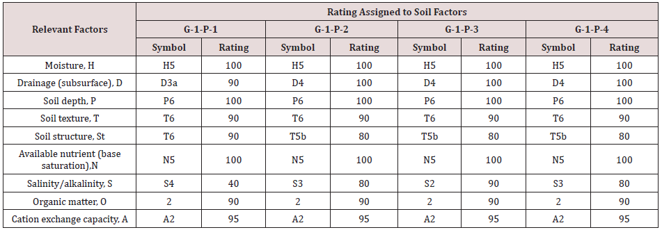
The parametric method as proposed by Riquier [2] for land evaluation is applied to assess the actual productivity (called productivity index, PI) of the soils under study. The quantitative approach to evaluate the productivity, as possessed by soils currently, would have helped to identify the number and magnitude of limitations associated with the actual productivity. Further analysis of the limitations, if correctable, would help to identify the possible improvement to be made to raise the rating of the land or soil to their maximum potential within the reach of the poor resource farmers. The improvement would raise the rating for the limiting soil factors to their potential level and calculation based on raised rating to the respective limiting soil factors would yield the index of potentiality (IP). Based on the criteria Riquier [2], the evaluation was made for the study area with all four pedons as PI and presented in Table 8. The classes of productivity (PI) as given in the criteria were compared and associated limitations were identified for suggesting improvement (Table 7). Any improvement approach for one limiting soil factor may also improve other limiting factors. Organic matter, for example, may improve soil organic status, but it may also improve soil structure and others.
Data in Table 6 show the ratings assigned to each soil factor
on the basis of the degree of deviation from optimal level. By this
is meant that the rating of 100 was assigned to those parameters,
which are optimal in terms of their contribution to productivity.
Symbols follow the stage of soil factors as given by Riquier [2]. All
the soils were receiving irrigation water and so the factor associated
with soil moisture was given 100. However, in some factors, which
were found to be limiting, were assigned ratings below 100 (Table
6). Based on such parametric evaluation, limitations were identified
with relative severity (Table 7). Maximum limitation was imposed
by salinity and alkalinity at alarming rate. The second limitation was
imposed by organic matter deficiency followed by cation exchange
capacity, soil structure and texture. Drainage was observed to be
poor only in the sub-surface horizons of Pedon 1. With regard to the
limitations imposed by CEC, organic matter, and soil structure, it is
well understood that the application of organic matter or otherwise management of organic resources not only promote the organic
matter status of soils to the desired level, but also improve soil
structure and CEC appreciably. Drainage problem in case of Pedon
1 requires construction of sub-surface drainage system, which will
not be possible to construct by a poor resource farmer. The texture
of soil is not correctable at least at farmer’s level. So, any limiting
environment with texture is normally considered to be beyond the
scope of improvement.
As such, the major improvement is associated with reclamation
and management of salinity and alkalinity both with soils as well as
water. Upto what extent improvement could be possible depends
upon nature and severity of problem, availability of amendments
required for improvement, government policy towards
improvement program, farmer’s awareness and participation
towards improvement, techniques to be used for judicious
application of canal water and so on. Some suggested improvement
activities may include leaching of salts, application of amendments
like pyrites (FeS2), growing of tolerant crops and treatment of
canal water with gypsum. Water showing high residual sodium
carbonate (RSC), for example, would be used for irrigation but
with the application of desired amount of gypsum to neutralize the
excess of RSC. Gypsum, for all practical proposes, may be used for
soil application at the rate of 0.1 ton per acre foot of waters for each
milliequivalent of RSC to be neutralized [3]. With proper care, thus,
salinity and alkalinity could be removed to the desired level. The
rating for this soil factor would go high and even to the maximum
level of 100 since hundred percent reclamation of saline-alkali soils
is possible with scientific management.
Data in Table 8 relate to the calculation for productivity index
(PI) based on the existing status as well as index of potentiality (IP)
after suggested improvement following the procedure suggested
by Riquier [2]. In terms of PI, Pedon 1 qualified “average” class of
productivity index, whereas rests of three pedons under “good”
class. When the ratings were given to soil factors after improvement,
soils of all four pedons qualified excellent class just by correcting the
limitations. The ratio of the index of potentiality to the productivity
index is called coefficient of improvement (CI). The data in Table
9indicate that Pedon 1 showed 2.86 value for C1, while Pedon 3 gave
1.62 and remaining two (Pedons 2 and 4) gave 1.82 values for CI.
Such ratio could be interpreted in economic terms by considering
simply the yield of a crop. Suppose maize, for example, gave a yield
of 2.5 t per hectare in a soil identical to Pedon 3. By this is meant
that the soil has imposed limitation exactly the same what is true to
Pedon 3. However, improvement to the correctable limitation has
raised the rating and so increased the productivity by 1.62 times.
With this understanding, the same crop after improving the soil
limitation could enhance the yield of maize by 1.62 times (2.5 x
1.62=4.05 t/ha). Such quantitative information would encourage
the planners, policy makers or even stakeholders to look for the
improvement of the land through management. Such parametric
land evaluation helps to assess the limitation in positive terms
(productivity). What is the degree and magnitude of productivity
in relation to production factors may be stated quantitatively which
production factors are actually limiting the actual productivity of
the soils. Obviously, all relevant land characteristics and qualities
need to be evaluated precisely to arrive at a concrete decision of the
change of land for the most remunerative return. Of course, in the
present context, soil factors have been given more emphasis since
the study site has almost identical climatic as well as topographic
conditions.
Table 8: Productivity index (PI), index of potentiality (IP) and coefficient of improvement (CI) of soils of west Gode.

Conclusion
The soils of west Gode are potentially very productive (excellent) and may be intensified for different crops with assured irrigation. However, due to emerging problem caused by salinity and alkalinity, the actual productivity of soils is at risk. This risk is the major cause of degradation–all physical, chemical, and biological. Of course, other factors are of minor importance in terms of improvement. The risk with existing agricultural activities is not merely individual, but it is solely related to canal water qualities. Irrigation canal is a fortune to the farming community of the whole catchment, but the water quality is polluting the potential soil resource of the entire area and the innocent mass of farming community is being affected. Such alarming situation calls for immediate intervention of the federal government and a policy thereof in order to prepare a strategic planning to mitigate the emerging problem at its initial stage. In order to secure that food production, the government should prioritize the area for strategic planning and implementation of the control measures to safeguard the collapsible lands for sustainable production, since salinity and alkalinity is often referred to as a cancer disease of soil.
Immediate Future Trend of Research and Related Activities Warranted
In view the immediate concern of the emerging problems of salinity and alkalinity in the west Gode area of Somali region of Ethiopia, the following activities are of immediate concern to SoRPARI, stakeholders as well as federal government of Ethiopia in order to restore the soil productivity for food production on sustainable basis.
a) Canal water quality and its impact on various soil fertility
parameters need to be investigated in detail in order to suggest
some effective control and improvement measures.
b) Excess irrigation to the crop fields should be avoided and
judicious water use according to actual water requirement
of growing crops should be defined in order to facilitate the
farmers to be familiar to the techniques.
c) Salt tolerant crops in rotation should be identified to grow
with judicious use of canal water.
d) SoRPARI should promote the existing infrastructure with
extension agencies in order to train the farming community
for the best and sustainable use of soils with necessary
precautions to restore the potential productivity.
e) Intervention of the federal government is urgently call for
through policy in order to safeguard the alarming threat
caused by emerging problems of salinity and alkalinity in the
whole catchment. Any delay in addressing the situation may be
disastrous in terms of food security programme of the country.
f) Green revolution in the area should be tagged with white
revolution through the government policy in order to
accelerate the economic growth of the rural community.
g) Both small- and large-scale industries are of priority in order
to boost up the twin valuable resources which are very relevant
to the area.
h) Transport and market avenues are to be developed for better
return of the produce, since the area has great problems
related to roads and markets.
Acknowledgements
The authors are greatly indebted to the encouragement and necessary cooperation extended by Mr. Ahmed Sheik Mohammed, Director General of SoRPARI. Thanks are due to Abdiaziz Sheik Abdullahi for necessary cooperation during photography and scanning of relevant research materials used in the paper. We are thankful to Miss. Maryan Sheik Abdurahman for typing the document nicely within a very short time. The cooperation extended by the then Alemaya University (Haramaya University), Ethiopia through their technical guidance is gratefully acknowledged especially for the interest extended by Late Professor Heluf Gebrekidan. The delay in late publication is due to return of Professor B B Mishra to India after completion of his contract under World Bank Project.
References
- Mishra BB, Heluf Gebrekidan, Kibebew Kibret (2004) Soil of Ethiopia: Perception, appraisal, and constraints in relation to food security. J Food Agric Environ 2: 267-279.
- Riquier J, Bramao DL, Cornet JP (1970) A new system of soil appraisal in terms of actual and potential productivity. FAO Soil Resources, Development and Conservation Service, Land and Water Development Division. FAO Rome p. 38.
- Singh, Dhyan, Chhonkar PK, Pandey RN (1999) Soil Plant Water Analysis: A Method Manual, Indian Agricultural Research Institute, ICAR, New Delhi, India.

Top Editors
-

Mark E Smith
Bio chemistry
University of Texas Medical Branch, USA -

Lawrence A Presley
Department of Criminal Justice
Liberty University, USA -

Thomas W Miller
Department of Psychiatry
University of Kentucky, USA -

Gjumrakch Aliev
Department of Medicine
Gally International Biomedical Research & Consulting LLC, USA -

Christopher Bryant
Department of Urbanisation and Agricultural
Montreal university, USA -

Robert William Frare
Oral & Maxillofacial Pathology
New York University, USA -

Rudolph Modesto Navari
Gastroenterology and Hepatology
University of Alabama, UK -

Andrew Hague
Department of Medicine
Universities of Bradford, UK -

George Gregory Buttigieg
Maltese College of Obstetrics and Gynaecology, Europe -

Chen-Hsiung Yeh
Oncology
Circulogene Theranostics, England -
.png)
Emilio Bucio-Carrillo
Radiation Chemistry
National University of Mexico, USA -
.jpg)
Casey J Grenier
Analytical Chemistry
Wentworth Institute of Technology, USA -
Hany Atalah
Minimally Invasive Surgery
Mercer University school of Medicine, USA -

Abu-Hussein Muhamad
Pediatric Dentistry
University of Athens , Greece

The annual scholar awards from Lupine Publishers honor a selected number Read More...


