Lupine Publishers Group
Lupine Publishers
Menu
Research ArticleOpen Access 
Research Trends in Water Management by Using Environmental Parameters Derived from Remote Sensing Volume 1 - Issue 1
Gema Marco Dos Santos, Jose Navarro Pedreño*, Ignacio Meléndez Pastor and Ignacio Gómez Lucas
- Department of Agrochemistry and Environment, University Miguel Hernández of Elche, Spain
Received: October 29, 2019 Published: November 07, 2019
Corresponding author: Jose Navarro Pedreño, Department of Agrochemistry and Environment, University Miguel Hernández of Elche, Spain
DOI: 10.32474/JBRS.2019.01.000103
Abstract
Water management is one of the most important strategies for sustainability. In many regions, this management is not easy and remote sensing can be useful to have data about the water status, especially from environmental derived indices associated with satellite data. It is important to know the research trends based on water management and remote sensing. Policy decision making in water management could be assisted and improved considering this tool. The aim of this work is to explore remote sensing articles that use environmental indicators in the last twenty years for the study of water resources by using a bibliometric analysis.
Keywords: Evapotranspiration; Soil Moisture; Vegetation index; Water Reservoir
Introduction
Water is an essential resource for social, environmental, economic and technological development [1]. Therefore, protection of the planet’s water resources and minimization of the impacts that our activities generate on them is crucial. In fact, guaranteeing the availability of water and its sustainable management is one of the goals of the 2030 Agenda for Sustainable Development [2]. With the rapid population growth, it is necessary to guarantee both access to quality drinking water and food production. For this reason, agriculture is one of the main human activity that generates more pressure, not only on water consumption, but also on groundwater and surface water pollution. Other industrial activities or energy generation also have a direct implication on water quality. It is of great importance for the maintenance of societies and ecosystems to implement efficient policies for water management and promote the development of sustainable technologies, especially taking into account the future climatic conditions of water scarcity under the different scenarios of climate change. Behind the water management and the scarcity of renewable resources, there are severe latent socioeconomic conflicts.
In many regions of the world, water management is complex for several reasons, but accessibility to control and measure the resource is one of the most important. Remote sensing has evidenced to be a multidisciplinary, very useful and effective tool for the study of the Earth environmental processes and resources. Due to the amount of information collected and the data processing capability of time series at different scales, remote sensing allows the development of methodologies in order to improve knowledge about the elements implied and the water dynamics and obtaining models that help in decision-making. Remote sensing is used in a wide variety of studies and in recent decades, a large number of indices have been developed such as those based on measuring vegetation properties. The role of vegetation indices as valuable biophysical data for models have been highlighted by several authors [3]. Reservoirs, among others, are key elements of surface water management thus monitoring their dynamic is essential for policy makers [4]. As well, irrigation is one of the main activities to take into account in water management therefore, knowing the soil moisture content can be influenced by agricultural irrigation practices [5].
Under a global view, it could be helpful to determine the trend of the research on the use of remote sensing and water management. In this case, the study of environmental and biological derived indices used in remote sensing and a bibliometric analysis can be used to know the impact or research potential and science community contribution. A bibliometric study allows us to perform a statistic and descriptive analysis to evaluate and quantify the evolution of different fields in order to know the scientific community advances, the interest or impact of an issue, the research potential, etcetera [6]. Although there are several scientific and multidisciplinary databases such as Google Scholar or ScienceDirect, Scopus [7] offers a wide peer-reviewed publications and implements for a preliminary literature analysis despite being a subscription citation database. The aim of this work is to explore remote sensing methods that use environmental indicators over the last twenty years to the study of water resources and management by using a bibliometric analysis.
Materials and Methods
A descriptive-retrospective bibliometric study of the last 20 years (2000-2019) of articles indexed in the Scopus database (conference paper, review, books, chapters, etc. were excluded) was performed using the keywords “water management” and “remote sensing” as starting point of search. The advanced search was applied after that with different keywords related to water management and remote sensing. The field code title-abs-key were used with different environmental terms. These terms are associated with biological indicators and were vegetation index, soil moisture and reservoir.
From Each of Them, the Search was Narrowed Down Adding more terms as Follow:
a) To the term “vegetation index”, “NDVI” (Normalized
Difference Vegetation Index) or “LAI” (Leaf Area Index) were
added. Both common indices used in remote sensing.
b) “Soil moisture” was complemented with
“Evapotranspiration” or “SWI” (Soil Water Index).
c) The terms “evaporation”, “water level”, “surface” and
“vegetation” were used after searching by using “reservoir”.
Results and Discussion
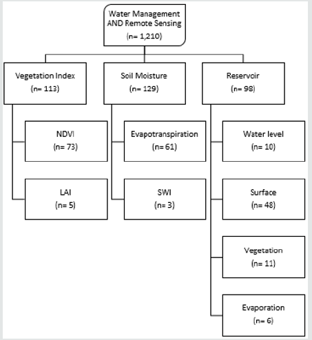
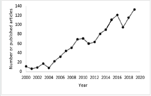
The information analyzed comes from a total number of 1,205 articles obtained searching by using the terms “water management” and “remote sensing”, published between 2000 and 2019. Figure 1 shows the number of articles published containing only the terms used. Therefore, 112 documents of the initial 1,205 fit with “vegetation index” as a search term and in this group, 73 results were obtained searching with “NDVI” and only 5 with the term “LAI”. After the search by using “soil moisture” (129 articles), the term “evapotranspiration” gave 61 results, and the “SWI” only 3. Moreover, 96 articles of “reservoir” were searched where 48 were associated with “surface”, and 10 with “water level”, 11 related to “reservoir” plus “vegetation”, and 6 articles with “evaporation”. One of the most important results is that the publications has been increasing in recent years, mainly since 2004 as Figure 2 shows. This increment may be related with different dry periods over the world in the last years that concern researchers about the importance of these studies based on a global tool like remote sensing and the sue of satellite images. According to World Resources Institute and FAO, some regions as Northern Africa, Central Asia, Southern and Eastern Asia, Oceania and Southern and Central America are exposed to water stress [8,9]. For instance, in Europe during the years 2004 to 2007 the drought affected mainly to the Iberian Peninsula and it was one of the worst in recent years causing severe socioeconomic impacts [10]. Between 2012 and 2014 the United States experienced one of the most severe drought in which 60% of the territory and the 80% of productive agriculture lands were affected [11]. In this sense, this review wants to point to the need to study water management from the perspective of climate change and the use of remote sensing as a basic tool.
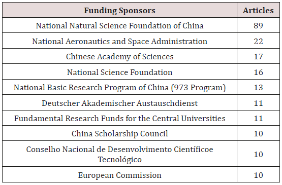
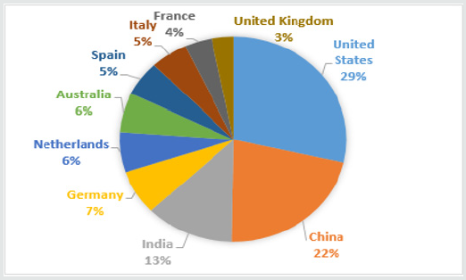
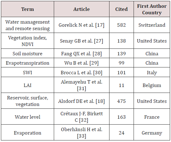
The countries that have published more articles about “water management” and “remote sensing” topics found in Scopus database are shown in Figure 3. Some of the reasons that could explain this distribution are the climatic, social and economic conditions of the country, the scientific community concern, the technological facilities or the investment by public and private organizations. It is important to notice that 51% of the articles are from United States of America and China, two countries that cover a large area, present very different climatic patterns and have important satellite programs. In the United States, there is a great interest in research on water resources, especially for irrigation and electricity generation, but in which there are no unify water management plans [12]. China is a country with a great agricultural development. There are arid and semi-arid areas as in northern of China with problems of overexploitation of water resources [13]. Many space and satellite programs depend on the China National Space Agency (CNSA) and others Chinese institutions and, as Table 1 shows, they sponsored many articles about remote sensing and water management. The third country with important research on water management and remote sensing is India. This country has regions with great precipitation patterns fluctuations. There are areas in which, the growing population does not have access to drinking water. Moreover, agriculture is the economic driver and traditional irrigation methods are still used [13,14]. In fact, India is one of the countries more involved in satellite and space programs and has undergone a rapid expansion in recent decades [15].
Table 2: Impact metric in the journals with more published articles about “water management” and “remote sensing”.
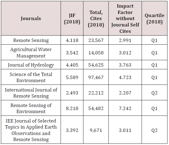
Table 3: Top ten most cited articles about “water management” and “remote sensing” in the last twenty years.
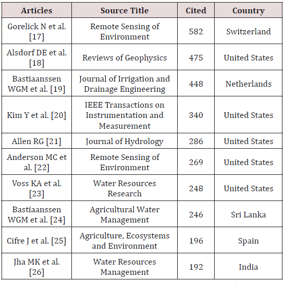
After this overview, the impacts on Scientific Community are presented in the following tables. Table 2 shows the metric impact of the journals with more published articles about remote sensing and water management in the last 20 years considering the Journal Citation Reports (JCR) [16]. Only two of the journals described in Table 2 are in Q2, the rest of them are in Q1. However, Table 3 shows the 10 most cited articles, and as it can be observed, only 4 of them are published in the journals mentioned in Table 2. Moreover, except for “Journal of Irrigation and Drainage Engineering” which is in Q3, all of the rest articles are published in Q1 journals. Table 3 presents the most cited articles about water management and remote sensing and, in Table 4, the most cited articles according to the keywords used. Only two articles are in both tables, which means that environmental derived indices (from vegetation and soil) do not have the same consideration for all the scientific community involved in remote sensing plus water management. According to the Figure 3, articles per country, and Tables 3 and 4, United States of America is the country with more publications, even though collaborations between countries are very frequent due to the presence of researchers of several countries as coauthors. The author who most articles has provided in relation with water management and remote sensing is from Netherlands as Table 5 reports, but most of the top ten authors are from the United States of America.
Table 5: Top ten authors and number of published articles about “water management” and “remote sensing”.
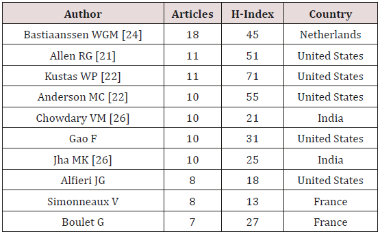
In addition, among the most cited articles are some where the first author is Bastiaanssen, W.G.M., Allen, R.G. or Anderson, M.C. In this sense, these authors are key researchers in the scientific community taking into consideration water management and remote sensing.
Conclusion
According to this search carried out in Scopus database, United States of America, China and India are the countries with more articles published by their researches as first author about remote sensing and water management. They are involved in important space and satellite programs and have a great technological potential. Moreover, their administration supports this type of research and favor the technological progress in remote sensing. The rest of the countries are mainly situated in the European Union and Australia. Vegetation (vegetation and vegetation index) is the biological parameter that appears in the majority of the articles and soil is less considered. In general, vegetation indices are easily to obtain from satellite data (many sensors have the Red and Infrared band to measure this parameter) although new satellite sensors are improving the capability to study soil moisture. The management of renewable resources would be based in the use of sensors and biosensors, and what is desirable is that this technology can be extended to developing countries to help them to sustainable resource management and policymaking.
References
- WWAP (UNESCO World Water Assesment Programe) (2019) The United Nations world water development report 2019: leaving no one behind, UNESCO, Paris.
- United Nations (2019) The Sustainable Development Goals Report 2019. New York, USA.
- Marco Dos Santos G, Meléndez-Pastor I, Navarro-Pedreño J, Gómez Lucas I (2019) A Review of Landsat TM/ETM based Vegetation Indices as Applied to Wetland Ecosystems. Journal of Geographical Research 2(1): 35-49.
- Giardino C, Bresciani M, Villa P, Martinelli A (2010) Application of Remote Sensing in Water Resource Management: The Case Study of Lake Trasimeno, Italy. Water Resources Management 24(14): 3885–3899.
- Zaussinger F, Dorigo W, Gruber A, Tarpanelli A, Filippucci P, et al. (2019) Estimating irrigation water use over the contiguous United States by combining satellite and reanalysis soil moisture data. Hydrology and Earth System Sciences 23(2): 897-923.
- Ball R (2017) An Introduction to Bibliometrics. New Developments and Trends. Chandos Publishing (Oxford). 1 edition.
- https://www.elsevier.com/solutions/scopus.
- AQUASTAT - FAO’s Global Information System on Water and Agriculture.
- Paul R, Shiao T, Gassert F (2013) Aqueduct water risk frame. World Resources Institute. Washington, DC.
- European Drought Centre (2013) Drought of 2004-2007: Iberian Peninsula.
- S Wallander, M Aillery, D Hellerstein, M Hand (2013) The Role of Conservation Programs in Drought Risk Adaptation. Economic Research Report. USDA.
- Pulido-Velazquez M, Ward F A (2016) Comparison of Water Management Institutions and Approaches in the United States and Europe-What Can We Learn From Each Other? Competition for Water Resources: Experiences and Management Approaches in the US and Europe. pp. 423-441
- FAO (2012) Irrigation in Southern and Eastern Asia in figures. AQUASTAT Survey – 2011. FAO Water Repots. Food and Agriculture Organization of The United Nations.
- Relph S (2019) Indian villages lie empty as drought forces thousands to flee. The Guardian.
- Williams M S (2019) Space Programs Around the World. Interesting Engineering.
- Journal Citation Reports (JCR).
- Gorelick N, Hancher M, Dixon M, Ilyushchenko S, Thau D, et al. (2017) Google Earth Engine: Planetary-scale geospatial analysis for everyone. Remote Sensing of Environment 202(1): 18-27.
- Alsdorf D E, Rodríguez E, Lettenmaier D P (2007) Measuring surface water from space. Reviews of Geophysics 45(2): RG2002.
- Bastiaanssen W G M, Noordman E J M, Pelgrum H, Davids G, Thoreson B P, et al. (2005) SEBAL Model with Remotely Sensed Data to Improve Water-Resources Management under Actual Field Conditions. Journal of Irrigation and Drainage Engineering 131(1): 85-93.
- Yunseop Kim, Evans R G, Iversen W M (2008) Remote Sensing and Control of an Irrigation System Using a Distributed Wireless Sensor Network. IEEE Transactions on Instrumentation and Measurement 57(7): 1379-1387.
- Allen R (2000) Using the FAO-56 dual crop coefficient method over an irrigated region as part of an evapotranspiration intercomparison study. Journal of Hydrology 229(1-2): 27-41.
- Anderson M C, Allen R G, Morse A, Kustas W P (2012) Use of Landsat thermal imagery in monitoring evapotranspiration and managing water resources. Remote Sensing of Environment 122: 50-65.
- Voss K A, Famiglietti J S, Lo M, De Linage C, Rodell M, Swenson S C (2013) Groundwater depletion in the Middle East from GRACE with implications for transboundary water management in the Tigris-Euphrates-Western Iran region. Water Resources Research 49(2): 904-914.
- Bastiaanssen W G, Molden D J, Makin I W (2000) Remote sensing for irrigated agriculture: examples from research and possible applications. Agricultural Water Management 46(2): 137-155.
- Cifre J, Bota J, Escalona J M, Medrano H, Flexas J (2005) Physiological tools for irrigation scheduling in grapevine (Vitis vinifera L.). Agriculture, Ecosystems & Environment 106(2-3): 159-170.
- Jha MK, Chowdhury A, Chowdary VM, Peiffer S (2007) Groundwater management and development by integrated remote sensing and geographic information systems: prospects and constraints. Water Resources Management 21(2): 427-467.
- Senay G, Budde M, Verdin J, Melesse A (2007) A Coupled Remote Sensing and Simplified Surface Energy Balance Approach to Estimate Actual Evapotranspiration from Irrigated Fields. Sensors 7(6): 979-1000.
- Fang QX, Ma L, Green TR, Yu Q, Wang TD, et al. (2010) Water resources and water use efficiency in the North China Plain: Current status and agronomic management options. Agricultural Water Management 97(8): 1102-1116.
- Wu B, Yan N, Xiong J, Bastiaanssen WGM, Zhu W, et al. (2012) Validation of ETWatch using field measurements at diverse landscapes: A case study in Hai Basin of China. Journal of Hydrology 436–437(2): 67-80.
- Brocca L, Melone F, Moramarco T, Wagner W, Hasenauer S (2010) ASCAT soil wetness index validation through in situ and modeled soil moisture data in central Italy. Remote Sensing of Environment 114(11): 2745-2755.
- Alemayehu T, Van Griensven A, Woldegiorgis B T, Bauwens W (2017) An improved SWAT vegetation growth module and its evaluation for four tropical ecosystems. Hydrology and Earth System Sciences 21(9): 4449-4467.
- Crétaux J F, Birkett C (2006) Lake studies from satellite radar altimetry. Comptes Rendus Geoscience 338(14-15): 1098-1112.
- Oberhänsli H, Weise S M, Stanichny S (2009) Oxygen and hydrogen isotopic water characteristics of the Aral Sea, Central Asia. Journal of Marine Systems 76(3): 310-321.

Top Editors
-

Mark E Smith
Bio chemistry
University of Texas Medical Branch, USA -

Lawrence A Presley
Department of Criminal Justice
Liberty University, USA -

Thomas W Miller
Department of Psychiatry
University of Kentucky, USA -

Gjumrakch Aliev
Department of Medicine
Gally International Biomedical Research & Consulting LLC, USA -

Christopher Bryant
Department of Urbanisation and Agricultural
Montreal university, USA -

Robert William Frare
Oral & Maxillofacial Pathology
New York University, USA -

Rudolph Modesto Navari
Gastroenterology and Hepatology
University of Alabama, UK -

Andrew Hague
Department of Medicine
Universities of Bradford, UK -

George Gregory Buttigieg
Maltese College of Obstetrics and Gynaecology, Europe -

Chen-Hsiung Yeh
Oncology
Circulogene Theranostics, England -
.png)
Emilio Bucio-Carrillo
Radiation Chemistry
National University of Mexico, USA -
.jpg)
Casey J Grenier
Analytical Chemistry
Wentworth Institute of Technology, USA -
Hany Atalah
Minimally Invasive Surgery
Mercer University school of Medicine, USA -

Abu-Hussein Muhamad
Pediatric Dentistry
University of Athens , Greece

The annual scholar awards from Lupine Publishers honor a selected number Read More...


