Lupine Publishers Group
Lupine Publishers
Menu
ISSN: 2690-5752
Research Article(ISSN: 2690-5752) 
The Geological Knowledge and Its Contribution to the Development of Mycenaean Cemeteries in Argostoli Area, Kefalonia Greece Volume 7 - Issue 4
A Zelilidis1*, E Zoumpouli1, P Papadopoulou1, N Bourli1, P Zelilidis1, G Grigorakakis2, E Papafloratou2 and G Iliopoulos1
- 1Department of Geology, University of Patras, Patras, Greece
- 2Ephorate of Antiquities of Kephalonia and Ithaki, Ministry of Culture and Sports, Kefalonia, Greece
Received:December 27, 2022; Published: January 25, 2023
Corresponding author: Avraam Zelilidis, Department of Geology, University of Patras, Patras, Greece
DOI: 10.32474/JAAS.2023.07.000268
Abstract
Abstract
The geological condition of two well-known Mycenaean cemeteries at Mazarakata and Lakithra and one less known cemetery at Metaxata, all located east of Argostoli town, were studied. During the Mycenaean civilization, three millennia earlier, the properties of the rocks were well-known to local residents. In these rocks, they have carved the famous chambered tombs. According to Mycenaean burial customs when Mycenaeans were preparing chambered tombs, they followed/used three major geological parameters/steps in order to develop a cemetery. The first parameter/step was to verify the local stratigraphy (the sequence of the different rocks). This was an important factor as the upper part of the tombs should consist of a strongly cemented rock, which could be used as the roof of the chambers. Under this upper part carvable rocks should exist suitable to build the chamber and the tombs. The second parameter/step was to locate the extended areas where their cemeteries could develop. For this reason, they opened exploration holes. Depending on the results, they decided whether they should continue or stop the cemetery development. At Mazarakata cemetery, there are thirty-seven (37) exploration holes with a mean diameter of 0.98m and a mean depth of 1.18m. At Lakithra cemetery, there are thirteen (13) exploration holes with a mean diameter of 0.89m and a mean depth of 1.26m. The third parameter/step was to identify areas with existing faults. The fault activity loosens the rock’s cohesion making it more easily carved. All exploration holes are situated along faults with an ENE-WSW direction, whereas most of the chambered tombs have been developed perpendicularly along the fault planes.
At Mazarakata cemetery, there are three major normal faults, and many other minor ones, with an ENE-WSW direction that deep both southwards and northwards and with a total displacement of 1.5m. Some of the above mentioned faults characterize a fault zone. In it, the rocks appear strongly cracked and thus carving was fairly easy. The Mycenaean cemeteries were situated at a small distance from the respective settlements. In addition, in many cases, the cemeteries are known but the settlements to which they belonged, remain unknown. According to these data, the settlements to which the herein described cemeteries belonged are suggested to be situated under or at the base of the younger Agios Georgios castle, which had been developed during the 12th century AD.
Keywords: Mycenaean cemeteries, chamber tombs, deltaic deposits, Kefalonia Island
Introduction
Late Helladic period (LH) constitutes the final stage of the periodization of the Bronze Age (ΒΑ) as far as the Aegean world is concerned [1]. Its origins are traced back in the Middle Bronze Age (MBA), whence, starting from the Shaft Grave period, local elites are emerging, exhibiting their immense wealth and powerful status [2]. The LH period culminates in the development of elaborate, great Palaces, centers of political, military and economic power. Although, in the periphery (in the spatial sense, nothing to do with Center Periphery models) of the later LHIIIA-B palatial centers, archaeological material from Kefalonia testifies to agencies and social procedures also observed throughout the mainland from the MHIII to LHI period [2]-from Sesklo, to Argos and Laconia, from Aegina to Lefkada, Ithaki and Kefalonia [3-10]. With the famous warrior shaft grave from Kolona (Aigina) as the initial milestone, a process of social development is evolving up to the early mycenaean period and the end of use of the Grave Circle A at Mycenae, with Kefalonia (as well as Lefkada and Ithaki) being an active player from the MHIII onwards [11-16]. Therefore, as the archaeological evidence proves, and long before the palatial centers of power emerge in the mainland, certain, deep changes are taking place within the local communities. It is this procedure that gradually forms a “mycenaean”- with distinct local characteristics - identity for the islanders, perceptible to us through the funeral architecture, evolvement of funerary customs and negotiation of status of the dead [2,17].
Regional Setting
The funerary landscape of Kefalonia
Many Late Helladic Cemeteries are spread throughout the island. Clusters of rock-cut chamber tombs have been excavated at the peninsula of Paliki (Kontogennada, Parissata and Vouni spots), at Livatho (Metaxata, Lakithra) and at Krania (Diakata) [18-22]. The existence of another cluster at St. Pelagia spot near the coastline is mentioned as well [23]. A handful of tholos tombs are also reported. They are located throughout a vast area, almost the entire eastern part of the island, from Livatho southwards to Pronnoi region-two at Mazarakata, two at Kangelisses spot, the monumental one at Mavrata and the greatest of all at Tzanata – Borzi height [11,24-27]. The overall picture is supplemented by the schist graves, as well as the recently excavated warrior pit grave, a recent and unexpected prelude to the LH period on the island [28].
The rock-cut chamber tombs
Widely spread from Paliki to Livatho, rock- cut chamber tomb is the dominant grave type of LH funerary architecture on the island. A very detailed typology has been developed from 1988 onwards [18,20] (Table 1). The general characteristics can be summarized as such: Subterranean, carved in the natural bedrock (sandstone), consisting of an elongated passage/path (dromos) leading to the entrance (stomion), and the chamber. Within the chamber many shafts are hewn out of the rock bed, some very deep, arranged either in a dynamic manner/randomly or carved according to a grid pattern.
However, this is not the rule. A high degree of variability has been already detected related not only to the dimensions, shape or just the size of the main structural parts, but firstly and mainly to the absence of them (e.g., the dromos or the stomion at Lakithra), or to the high variation in terms of morphology (e.g., the dromos at Metaxata, Mazarakata). In Paliki peninsula structural homogeneity and cohesion is detected [12,18,19], but this is not the case for Livatho, (Mazarakata, Metaxata, Lakithra), even for tombs located in neighboring clusters, Metaxata for instance [18]. This was the main reason for the development of a typology aiming at the systemization of the archaeological approach. However, dating, or socioeconomic implications associated with the aforementioned typology have yet to be proved.
There is only one stable, universal, spatially engaged with the rock-cut tombs feature, either located in Paliki or on eastern Kefalonia. The so-called “siroi” are tubes or pits hewn out of the rock. Their diameter and depth vary. They have been unearthed near the tombs, but at Metaxata within the dromoi of two chamber tombs [11,12,24,25,29]. They even constitute an initial structural part of them-now hollow chamber roofs [28]. They had escaped attention for decades after Sp. Marinatos attributed them to farming activities [12]. That approach dominated in archaeological research till 2022. However, it is obvious that these tubes/pits are the remnants, the traces of both, a way of constructing tombs (Kontogennada, Parissata, Metaxata) and of a genius way LH craftsmen had devised to check the bedrock and save effort [28]. The clusters at Mazarakata, Lakithra and Metaxata constitute the perfect sample for us to study the phenomenon of Kefalonian rock-cut tombs on the Geological point of view. Geology is the background, the matter which gives substance to human creativity. It seems that environmental determinism and human genius played an important part in the construction of such monuments. Given the geological importance of the island, these humans made clusters constitute monuments both of Man and Nature.
Geological Setting
Figure 1: Simplified geological map of the studied area. The three cemeteries are marked with blue stars. Moreover, with the same blue star the Castle of Ag. Georgios is also marked.

The Kefalonia Island is part of the Western external Hellenides and is characterized by outcrops of different sedimentary sequences of the Pre-Apulian and Ionian isopic zones. Kefalonia Island lies at the external (foreland) edge of the Hellenides fold-and-thrust system created in response to Cenozoic continental collision that followed the closure of the Tethyan Ocean. Pre-Apulian zone (Apulian Platform Margins-APM) corresponded to the slope between the Apulian platform, at the west, and the Ionian basin, at the east. Synrift sedimentation persisted throughout the Cretaceous period to shallow marine carbonates on the ridges, mixed pelagic/neritic sedimentation on the slope (APM) and deep-water carbonates in the Ionian Basin (IB). The APM extends northwards through Lefkas and Paxoi/Antipaxoi islands into SW Albania and southwards to Zakynthos Island (Figure 1). [30] used seismic data and introduced that normal fault, during rift-stage, were influencing Mesozoic depositional conditions. These faults were reactivated as thrust faults during the Paleogene period (Eocene to Miocene epoch) and were further reactivated as normal faults during the Plio-Quaternary extensional stage [31]. In addition, [32,33] suggested that the synrift stage normal and transfer faults were re-activated during the compressional stage as thrust or back-thrusts and strike-slip faults, respectively. Furthermore, it has been observed that the thrusting activity of the branches of the main Ionian Thrust has led to the evolution of smaller, confined sub-basins, at least as it has been recorded on Kefalonia Island [31].
According to the geological map of Kefalonia Island [34], the studied area is characterized by Pliocene deposits that were accumulated in a NW-SE directed restricted sub-basin, developed between Mesozoic carbonates. The above Pliocene deposits in their lower part (lower Pliocene) are characterized by a short stratigraphic hiatus and transgressive well-bedded conglomerates. From the lower stratigraphic part to the upper, there is a limestone bed with plenty of Echinolampas tests, passing upwards into yellowish sand, sandstone, and sandy limestone with thin interbedded marly beds. The latter pass upwards into blue marls with an abundant mollusk fauna. Finally, in the uppermost part, there are interbedded fine-grained sandstones and sandy marls. The thickness of the Pliocene deposits ranges from 100m to 260m in the SW area.
According to Van Hinsbergen [35], in Cape Liakkas, Messinian clays are interbeded with mass-transported conglomerate and sand beds, at least 100m thick which dip east (50O). They are overlain by a sequence of Messinian evaporites, up to 100m thick, and the Lower Pliocene Trubi facies’ sediments and marls. The above mentioned deposits at Spartia coast are unconformably (angular unconformity) overlain by gently dipping Upper Pliocene silts, sands and calcarenites, with a total thickness of more than 300m. The paleobathymetry results showed that the conditions changed from deep marine (Trubi formation-around 700–800 m), to shallower depth (Spartia deposits-200-300m) and finally to 0-100m depth above the second unconformity. In summary, authors concluded that rapid Early Pliocene uplift affected southern Kefalonia and led to emergence and erosion, followed by the deposition of the Upper Pliocene shallow marine deposits of Spartia and Cape Katelios [36,37].
Methodology
For this study, three different tools were used.
a. Measurements of the exploration holes, as they represent a great part of the cemeteries.
b. The structural elements. The detailed description and measurement of fault planes with their strike and their dip direction, as they seem to have been used for the excavations of the existing exploration holes and for the tombs.
c. The sedimentological description and the stratigraphic sequence of each cemetery have been recorded, as it seems that all activities were based on the sediment lithology and their respective diagenetic ratio.
Field Data
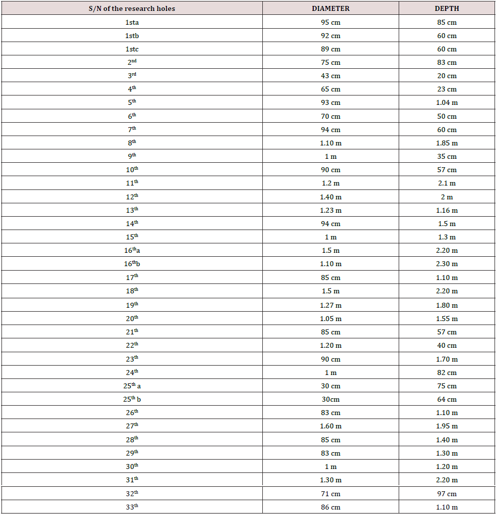
In relation to the exploration trenches, which are cylindrical, the following measurements were recorded
Figure 2: The northern part of the cemetery in Mazarakata. Τhe locations of the exploration holes are marked as well as the direction of bedding planes dip (with a red circle). For the location of this image, see red box in Figure 4.

Figure 3: The cemetery in Lakithra. The measured trenches are marked in Table 2. Numbers in the periphery of the figure correspond to the altitude of each position.

In Mazarakata cemetery, 37 trenches (Figure 2, Table 2) were measured. In three locations, two or even three trenches are closely spaced. These are site 1 with three trenches and sites 16 and 25 with two trenches. Their average diameter is 0.98m. Their average depth reaches 1.18 m. Some of the research holes could be test holes for the development of the two tombs, like those of site 1 where three holes are very closely located to each other. T1: width/ length 1.83 meters, depth 1.40 meters, T2: length 3.30 meters, depth 50 centimeters (Figure 2). In Lakithra cemetery (Figure 3, Table 3) 13 exploration holes were measured. Additionally, one more site with five (5) more possible exploration holes was studied. They were counted together and are marked in Figure 3 with a black box. The average diameter of the holes reaches 0.89 m, and their average depth is 1.26 m.
Figure 4: The cemetery in Mazarakata with all the structural elements measured and analyzed in the text. Red box (A) shows the position of Figure 1. Numbers in the periphery of the figure correspond to the altitude of each position.

In the Metaxata area where two funerary monuments were found, no research holes were identified (except for a site that may be a research hole. In Mazarakata cemetery, five major faults were measured between the holes (position C in Figure. 4). These faults have a general E-W direction, dipping south (168/80) and north (348/85) respectively, creating structural highs and trenches, from the antithetic faults and/or the synthetic faults. From the highest point on the concrete corridor looking northwards, the five faults (see Fig. 4) are: P1: 168/80, with fault displacement of 15 cm. P4: 330/55 and fault displacement of 51 cm. P5: 321/73 and displacement of 48 cm. P6: 159/85 and displacement of 40 cm. P7: 348/85. The bedding planes’ dip remains constant. A representative measurement between the holes 15 and 8, is 70/10 (Figure 2).
At the southern part of the burial monuments, in areas B and D, the following measurements were taken: The main fault (fault P1 in Figure 4), with an E-W orientation, and a south dip direction (166/86). It is divided into five parts, which from west to east are: 1st part: north of the concrete road, 2nd part: south of the concrete road, 3rd part: in the tunnel leading to the main burial monument. In this dromos, the fault has a southern slope (172/85) with a fault zone expressed with an open space of 90cm. In the middle of the dromos, a fault was measured with an E-W orientation and a northern slope (0/56). A second fault with an E-W orientation as well but with a southern slope (156/80) “stops” on the surface of the main fault. In addition, a fault with value 336/85 in the second tomb (the fault P2 in Figure 4) was measured. This second fault has almost an E-W orientation (like the previous ones) and a north slope. It seems to define all the coronations of the tunnels but also the coronation of the largest monument (position B). The same fault orientation and dip direction as the previous one (330/80), was measured in the penultimate dromos (fault P3 in Figure. 4). This seems to affect all the coronations of the funerary monuments (monuments 1, 2 and 3 in Figure 5).
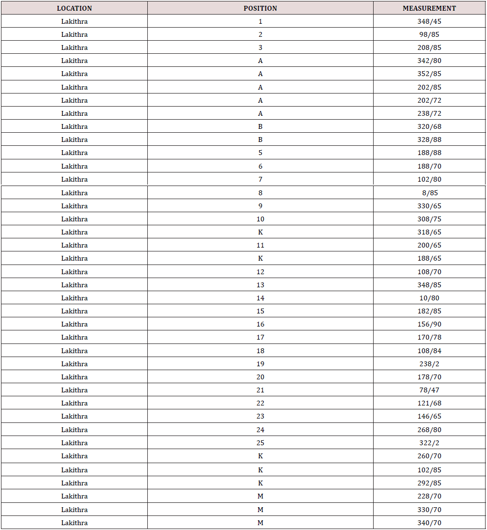
At site B, where the main burial monument was also studied, layers, joints, faults, and their branches (Table 4) were measured. Their locations are shown in Figure 5 and are given in detail in Table 4. In this location, also the E-W oriented faults with dip directions both north (340/70) and south (168/80) prevail. However, there are also faults (e.g., positions 27 and 28) which have N-S orientations and dip east. This is possibly linked to the fault’s surface expression that helps the surface disclosure of the E-W oriented faults rather than those in the N-S orientation. On the contrary, the almost circular disclosure of the burial site in area B helps in the surface expression of the N-S oriented faults. Observations of joints-faults-fault branches implies that joints with N-S orientation do not show displacements (therefore consist of branches) and are obviously NOT the main ones.
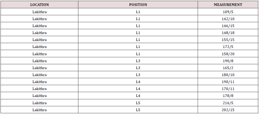
However, based on the existing geological data, the faults that exist and affect the evolution of the area, have a N-S orientation, while those with an E-W orientation are the transform faults and are not expected to cause displacements. In our case, the fact that shifts were observed due to the transfer fault activity is attributed to the “positive flower structures” that are created and cause the elevations. The troughs are formed by “negative flower structures”. In Lakithra cemetery, a limited number of faults was measured (Figure 2). Faults with N-S orientation and western dip were measured in the central part of the cemetery, and these are the ones that cause the cemetery area to sink west. In addition, in the western area of the cemetery, there are faults with an E-W orientation, and they are these that were used to open the two tombs in the SW area. In addition to the above faults, there are also several joints (Figure 6). It is not clear which of them are possibly faults, as no displacement was recognized on either side of the joints, and which are fault branches. Bedding planes in various positions were also measured. The locations of all of the above are shown on the map (Figure 6), and their values are given in Tables 5 & 6. The measured foreclosures have large deviations from each other, ranging from E-W (348/45- 188/75) with direction of inclinations both north (348/45) and south (188/75), and N-S (102/85-268/80) with direction of inclinations both east (102/85) and west (268/80).
Figure 6: The cemetery in Lakithra with the points (numbered points) or areas (with red frames and letters) where layers and branches were measured.

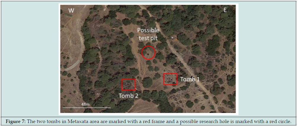
The measured layering indicates main dip directions to the south with values ranging from 5 to 20o.In the Metaxata area there are two tombs (Figure 7). Outside the first tomb, there is a fault with a N-S orientation and west dip direction (268/75). It has an approximately 50 cm displacement and many branches with a mainly E-W orientation (values 160/88, 167/85) or even with N-S orientation (104/63). The layer dips southwards (168/15). The entrance of the second tomb is controlled by two faults with E-W orientation and southward dip (value 176/90). Because of these faults the stomion - entrance is broken. A fault was also measured outside the tomb. It has the same dip direction (176/90). Above the tomb, the fault was measured again and has approximately the same orientation and dip (196/65). The dip of the layering is also to the south (180/15). Inside the tomb, faults with similar directions to those measured outside, were measured (174/75, 182/80 and 160/90).
Figure 7: The two tombs in Metaxata area are marked with a red frame and a possible research hole is marked with a red circle.
In relation to the stratigraphy of the sedimentary sequence of the tombs
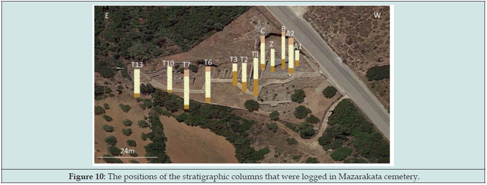
The carving of the tombs created sections that allowed the measurement of the layers’ thicknesses and the recording of the stratigraphy in all three cemeteries, which is quite different. More specifically: In Mazarakata, the stratigraphy (Figures 8-11) is characterized by: 180cm of sandy limestone. In this layer the tombs had been curved. Upwards, 230-310cm of calcitic sandstone with marine macrofossils are noticed. This layer is carved and was used as the vault of the tombs. The thickness of this layer is unstable. It is followed by 80cm of marly limestone. This is the uppermost layer and which is considered essential for the coronation of the tombs.
Figure 8: The two tombs in Metaxata area are marked with a red frame and a possible research hole is marked with a red circle.
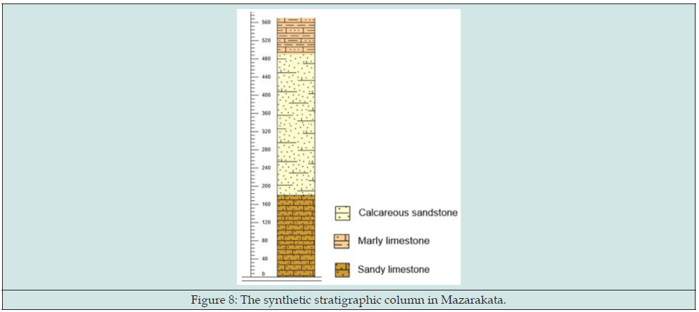
Figure 9: The locations of the studied sections and the respective measurements in Mazarakata cemetery that have been used for the stratigraphic correlation.
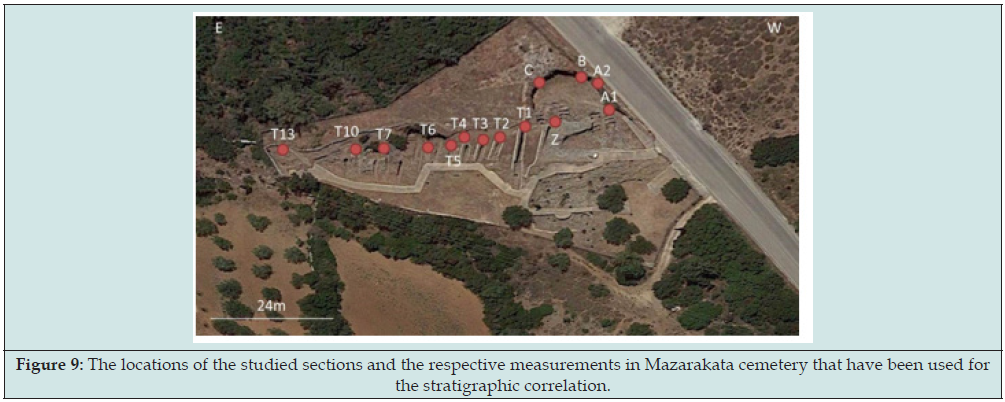
Figure 7: The two tombs in Metaxata area are marked with a red frame and a possible research hole is marked with a red circle.

Figure 11: The stratigraphic columns of the Mazarakata cemetery. The lower stratigraphic horizon was used as a baseline for comparison between the thicknesses of each layer in the different sites.

In Lakithra, the stratigraphy (Figures 12-15) was studied in five different sites (Figure 12) because of the intense relief and the dipping of the layers: In Lakithra the stratigraphy appears more complex. There are frequent lateral changes in the granulometric size of the clasters and in the thickness of the same layer. For this reason it is not possible to construct a single and representative stratigraphic column. In general, the stratigraphy of Lakithra, includes granules and sandstone layers alternating with sandy limestones. In the upper part of the sequence (L1) a layer of calcitic sandstone was found (Figures 12 & 13).
Figure 12: Satellite image (Google Earth) of the cemetery of Lakithra with the five locations where the lithology was measured and described, while the stratigraphic columns for each location were constructed.

Figure 13: Satellite image of Lakithra cemetery with the resulting stratigraphic columns. The red lines between the columns indicate their lateral correlation.

Figure 14: The stratigraphic columns in the cemetery of Lakithra placed in such an order to show their lateral correlation. The letters next to the columns indicate the cycles of sedimentation.
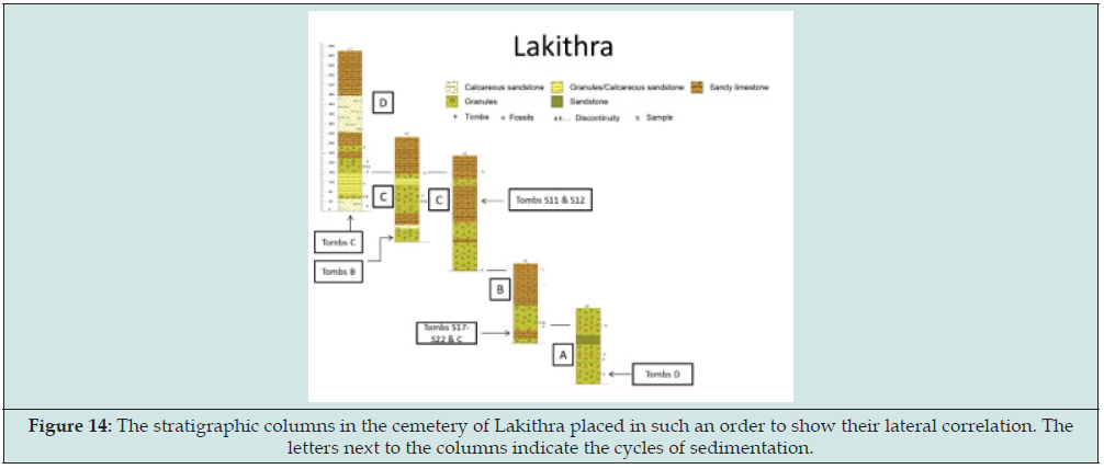
Figure 15: Sketching of the cemetery in Lakithra where the location of both the trenches and the tombs is noted.

More specifically (Figure 13), the lower stratigraphic levels can be noticed at position L5 (south): two layers of granules with fossilized calcareous algae, with a total thickness of 122cm followed by a layer of granules with normal grading and an 18cm thickness followed by a cohesive granule layer with a thickness of 23cm. The tombs of group D, laterally in the lower part of column L4, the tombs with codes S17 to S22, as well as those of group C (Figure 14) have been curved in this layer. A sandstone layer with a 38cm thickness follows. It passes laterally to sandy limestone (L4) and two granule layers, with a total thickness of 112cm. The next layer of the stratigraphic sequence can be seen at position L4. It consists of 150cm of sandy limestone which upwards seems more cohesive. It is followed by a layer of sandy limestone which laterally passes to a cohesive granule layer (L3), 120cm thick.
As can be noticed in the stratigraphic column L3, the previous layer is followed by 15cm of sandstone with a lateral transition to granule layers (stratigraphic column L2). In this layer the tombs of group B (Figure 14) are found. Another cohesive granule layer, 63cm thick, is following. This layer passes upwards and laterally to calcitic sandstone (L2). Further upwards, lateral and vertical alternations of layers of sandstones and granules with a total thickness of 376cm are found (L3, L2). In a sandstone layer in column L3 tombs S11 and S12 as well as a pit can be noticed (Figure 14).
At stratigraphic column L2, within a granule layer, a rich taphocoenosis of calcareous algae and mollusks has been recorded. To the east (L1), the lower levels of this layer pass to calcareous sandstone with a 52cm thickness. Within this layer tombs have been curved (Tombs of group A, Figure 14). It is followed by a thin granule layer with another rich taphocoenosis of calcareous algae and mollusks in which tombs have been also found (Tombs of group A, Figure 14). Upwards, the alternations of granules and calcareous sandstones increase in number, but the layers become very thin for a 92cm column height. Macrofossils are also found in this interval.
The sedimentary sequence continues (L1) with 150cm of vertical and lateral alternations of granules and calcareous sandstones of greater thickness than before (as described for those in column L2). In places, macrofossils appear in this section as well. These are followed by a layer of calcareous sandstone, 150cm thick and the sequence closes with 185cm of sandy limestone. The names of the tombs and the trenches of Metaxata cemetary as mentioned in Figure 16 have been used in order to match them with the respective layers in which they have been curved. Considering: the northern dip of the layers, the displacements of the faults, the lateral continuity of the layers and the alternations in the lithology, it is estimated that there are four cycles of sedimentation with different lithology and cohesiveness and therefore different mechanical strength.
Figure 16: The stratigraphic columns in Metaxata. TA corresponds to the western tomb and TB to the eastern tomb.
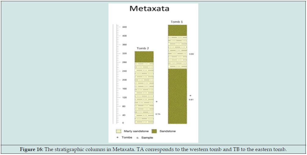
Figure 17: The stratigraphic columns in Metaxata placed on a google earth map to understand their distribution.

In Metaxata, the stratigraphy (Figure 16) resembles the one in Mazarakata. It is characterized by a thick layer of sandstone in the lower stratigraphic level with a thickness of 250cm. In this layer a tomb has been found (column TB, western tomb). Upwards a layer of marly limestone with a maximum thickness of 280cm, exists. In this layer a second tomb is also found but in a different location (eastern tomb, Figure 17). In this location the lower layer of sandstone was not recorded. Due to the facts that the layers dip to the south and the western tomb is located about 1.5m higher than the tomb in the east, it is estimated that the two tombs have been developed in different layers and that the sediments in the western tomb develop stratigraphically above those of the eastern tomb. However, the elevation difference between the two tombs can be attributed to the faults’ displacement. If this is the case, then both tombs may have been developed in the same stratigraphic sediment sequence.
Discussion
According to the aforementioned field analysis and taking into account the results, the following conclusions can be drawn: The sediments in the three cemeteries bare a Pliocene age and were deposited in a shallow marine environment and more specifically in a delta plain to delta front. The different stratigraphic composition from one cemetery to another has to do with their location in the deltaic system (channel axis, floodplain or overbank deposits). Three different sedimentary horizons were identified both in composition and in terms of diagenetic degree. This diversity was used by the Mycenaeans as a guide for the excavation of the tombs. The upper horizon is the most diagenetic-cohesive and was used as the roof of burial activities because it offered the stable roof. The middle horizon was less cohesive than the upper horizon and was intensively excavated. This layer was easy to curve but at the same time it could maintain the curvature required for the construction of vaulted parts. The third and lower horizon, although like the middle one, it is slightly more curved. This layer was the most suitable for the construction-digging of the tombs. In Mazarakata and Metaxata this succession of horizons is the same, while in Lakithra at least two successive circles with the respective three horizons can be identified. There is a fault system with two directions. The main one affects all three cemeteries and has an E-W orientation. The contribution of the second system which has N-S orientation does not seem equally important. The bedding planes showed south dipping surfaces with small slopes, ranging from 5-10o and only in Lakithra they reach up to 20o.
The exploration holes that exist seem to be associated with the presence of active faults. In particular, all the holes were developed on the ruptured surface that submerges the faults. Exploration holes seem to have been used for the identification of the stratigraphy, finally aiming at the development of domed burial activities. The two cemeteries, Mazarakata and Metaxata, are similar due to the small slope of the beds and the surface cover with the upper coherent and impermeable stratigraphic horizon. The third cemetery of Lakithra was developed on an inclined slope, has greater slopes and for this reason it was used at different altitude levels to develop burial activities. Thus, in Mazarakata and Metaxata the burial activities took place rather in a single stratigraphic horizon while in Lakithra in three different horizons. The Mycenaean cemeteries were situated at a small distance from the respective settlements. In addition, in many cases, the cemeteries are known but the settlements to which they belonged, remain unknown. According to these data, the settlements to which the herein described cemeteries belonged are suggested to be situated under or at the base of the younger Agios Georgios castle, which has been developed on the 12th century AD.
Supplementary Material
There are two videos from Mazarakata and Lakithra cemeteries.
References
- Manning SW (2010) Chronology and Terminology. In The Oxford Handbook of the Aegean Bronze Age. Oxford University Press pp. 48-64.
- Giannopoulos TG (2012) The Greeks: Whence and When? The mainstream scientific responses and the present state on the first beginning of the Greek civilisation. Heraclion, Crete University Press, Greece pp. 1-644.
- Papadimitriou N (2001) Built Chamber Tombs of Middle and Late Bronze Age Date in Mainland Greece and the Islands. British Archaeological Reports British Archaeological Reports-International Series (BAR) 925.
- Boyd MJ (2002) Middle Helladic and early Mycenaean mortuary practices in the southern and western Peloponnese. Archaeopress Oxford, UK pp. 1-268.
- Boyd MJ (2015) Becoming Mycenaean? The living, the dead, and the ancestors in the transformation of society in second millennium BC southern Greece. C Renfrew C, Boyd MJ, Morley I (eds) Death Rituals, Social Order and the Archaeology of Immortality in the Ancient World. Cambridge University Press, Oxford, UK pp 200-220.
- Heitz C (2008) Burying the palaces? Ideologies in the Shaft Grave period. University of Innsbruck, Austria pp. 1-35.
- Voutsaki S (2010) From the kinship economy to the palatial economy: The Argolid in the 2nd millennium BC. Pullen AD (ed) Political Economies in the Aegean Bronze. Oxbow pp. 86-111.
- Voutsaki S, Moutafi I, Hachtmann V (2022) The North Cemetery at Ayios Vasileios. Austerity and differentiation in the early Mycenaean period. In Middle and Late Helladic Laconia competing principalities? In: Wiersma C, Tsouli MP (eds) pp. 217-228.
- Lagia A, Cavanagh W (2010) Burials from Kouphovouno Sparta Lakonia. In Mesoelladika La Grece continentale au Bronze Moyen. In: Philippa-Touchais A, Touchais, G, Voutsaki S, Wright J (eds) Mesoelladika: The Greek Mainland in the Middle Bronze Age (Athens 2006), Bulletin de Correspondance Hellenique Sup. 52, pp 333-346.
- Dor L, Jannoray J, van Effenterre H, van Effenterre M (1960) Kirrha: etude de prehistoire phocidienne. E. de Boccard, Paris pp. 236-237.
- Kavvadias P (1912) On the Kefallinia Excavations, Proceedings of the Athens Archaeological Society (PAE) 247-268. (In Greek).
- Marinatos Sp (1933) The Cephalonia Goekoop II excavation. Archaeologiki Efimeris, (ΑΕ), 68-111. (In Greek).
- Dörpfeld W (1927) Alt-Ithaka: Ein Beitrag zur Homer-Frage, Studien und Ausgrabungen aus der insel Leukas-Ithaka. R. Uhde, München, Germany pp. 1-420.
- Wardle KA (1972) The Greek Bronze Age west of the Pindus. A study of the period ca. 3000-1000 BC in Epiros, Aitoloakarnania, the Ionian Islands and Albania with references to the Aegean, Adriatic and Balcan Regions. Thesis (Ph. D.). University of London, England.
- Kilian Dirlmeier Ι (1997) Das mittelbronzezeitliche Schachtgrab von Ä Kataloge vor- und frühgeschichtlicher Altertümer des RGZM Mainz, Band 27 (zugleich Alt-Ägina Band IV 3). Hrsg. H. Walter und E. Walter-Karydi. Verlag Philipp von Zabern, Mainz.
- Staikou B (2018) Recent Bronze Age findings at the foot of Scaros. A century after the surveys of W. Doerpfeld in the plain of Nidri Lefkada. In: the archaeological work in Aitoloakarnania and Lefkada. Proceedings of the Second International Archaeological and Historical Congress (Mesolongi 6-8 December 2013) (In Greek) pp. 433-440.
- Voskos I (2021) In Archaeology of the Ionian Sea: Landscapes, seascapes and the circulation of people, goods and ideas from the Palaeolithic to the end of the Bronze Age. Oxbow pp. 179-190.
- Sotiriou A, Nakassis Ag (2019) Tomb Architecture: Mycenaean cemeteries of Mazarakata and Lakithra. In I. The cemeteries. Spatial organization, burial customs and rituals. In E. Kountouri & A. Gadolou (Eds.), Archaeological Resources and Expropriation Fund (TAPA) pp. 517-556.
- Vikatou O (2018) The work of the Ephorate of Antiquities of Kefallinia 14-17. Kymothoi (In Greek) 8(1): 7-30.
- Souyoutzoglou Haywood Ch (1999) The Ionian Islands in the Bronze Age and Early Iron Age 3000–800 BC. Liverpool.
- Kyparissis N (1922) Cephalonian. Archaeological Bulletin (AD) 1919, 5. In Athens 83-122. (In Greek).
- Kyparissis N, Philadelpheus L (1913) Excavation in Kefallinia during the summer of 1912. Praktika tiw en Athinais Archaelogikis Etaireias 1912, 100-118. (In Greek).
- Iakovidis Sp (2000) Kefallinia, Ithaca and Zakynthos during the Mycenaean period. Proceedings of the 6th International Panionian Conference, Zakynthos September 23-27, 1997, vol. I, Thessaloniki 85-103. (In Greek).
- Kavvadias P (1909) Excavations in Kefallinia during the year 1908 17-112. (In Greek).
- Marinatos Sp (1932) The Goekoop excavation in Kefallinia I. Archaeologiki Efimeris, `1`(AE), 1-47. (In Greek).
- Voskos I, Metaxas Od (2019) The domed tomb of Mavrata 80 years later. Proceedings of the 11th International Panionian Conference, Argostoli (In Greek) pp. 124-137.
- Kolonas L (1992) Prefecture of Kefallinia. Tzannata Poros. Archaeologiko Deltio 47 B1 Chronicles 154-157. (In Greek).
- Grigorakakis G, Papafloratou E, Zoumpouli E (submitted) Chamber tombs and “Siroi”, Archaeology and Geosciences. An interdisciplinary approach to the technique of bedrock extraction and construction of chamber tombs in Kefalonia during the Late Helladic period. In The Archaeological Activity and Research in NW Greece and the Ionian Islands (3d Conference). Ioannina January 19-22/2022.
- Kalligas PG (1974) Cephalonian II (Mycenaean Cemetery of Mazarakata - Chamber Tomb in Metaxata). Archaeologika Analekta ex Athinon (AAA) 7(1): 186-189. (In Greek).
- Kokinou Ε, Kamberis Ε, Vafidis Α, Monopolis D, Ananiadis G, et al. (2005) Deep seismic reflection data from offshore western Greece: a new crustal model for the Ionian Sea. Journal of Petroleum Geology 28(2): 81-98.
- Zelilidis A, Bourli N, Zoumpouli E, Maravelis A (2022) Tectonic inversion and deformation differences in the transition from Ionian Basin to Apulian platform: the example from Ionian Islands, Greece. Arab Jour Geosciences (accepted for publication).
- Basilone L, Sulli A (2018) Basin analysis in the Southern Tethyan margin: Facies sequences, stratal pattern and subsidence history highlight extension-to-inversion processes in the Cretaceous Panormide carbonate platform (NW Sicily). Sedimentary Geology 363(1): 235-251.
- Bourli N, Pantopoulos G, Maravelis AG, Zoumpoulis E, Iliopoulos, G, et al. (2019) Late Cretaceous to early Eocene geological history of the eastern Ionian Basin, southwestern Greece: a sedimentological approach. Cretaceous Journal 98(1): 47-71.
- IGME (1985) Geological Map of Greece 1:50.000. Sheet Cephalonia Island (southern Part).
- Van Hinsbergen DJJ, van der Meer DG, Zachariasse WJ, Meulenkamp JE (2006) Deformation of western Greece during Neogene clockwise rotation and collision Apulia. Int. J. Earth Sci (Geol Rundsch) 95(1): 463-490.
- Grigorakakis G, Papafloratou E (submitted) The Warrior tomb from Borzi height, S. Kefalonia. Social changes at the dawn of LH.
- Sotiriou A, Papafloratou E, Voskos I, Tzanni E (2018) Mycenaean Kefalonia: The recent excavation surveys on the island. In: Proceedings of the First Conference on the Archaeological Work in NW Greece and the Ionian Islands, (Ioannina 14), ed. TAPA pp. 757-766.

Top Editors
-

Mark E Smith
Bio chemistry
University of Texas Medical Branch, USA -

Lawrence A Presley
Department of Criminal Justice
Liberty University, USA -

Thomas W Miller
Department of Psychiatry
University of Kentucky, USA -

Gjumrakch Aliev
Department of Medicine
Gally International Biomedical Research & Consulting LLC, USA -

Christopher Bryant
Department of Urbanisation and Agricultural
Montreal university, USA -

Robert William Frare
Oral & Maxillofacial Pathology
New York University, USA -

Rudolph Modesto Navari
Gastroenterology and Hepatology
University of Alabama, UK -

Andrew Hague
Department of Medicine
Universities of Bradford, UK -

George Gregory Buttigieg
Maltese College of Obstetrics and Gynaecology, Europe -

Chen-Hsiung Yeh
Oncology
Circulogene Theranostics, England -
.png)
Emilio Bucio-Carrillo
Radiation Chemistry
National University of Mexico, USA -
.jpg)
Casey J Grenier
Analytical Chemistry
Wentworth Institute of Technology, USA -
Hany Atalah
Minimally Invasive Surgery
Mercer University school of Medicine, USA -

Abu-Hussein Muhamad
Pediatric Dentistry
University of Athens , Greece

The annual scholar awards from Lupine Publishers honor a selected number Read More...


