Lupine Publishers Group
Lupine Publishers
Menu
ISSN: 2690-5752
Research Article(ISSN: 2690-5752) 
Approach to the Palaeotopographic Recreation of the Cerro De Palomarejo (Montoro, Córdoba). Lidar and Virtual Archaeology as Basic Tools in the Historical-Archaeological Recreation of Environments Volume 8 - Issue 4
Sicre González, Pablo*
Historian, Archaeologist and Heritage Virtualiser, University of Cadiz, Spain
Received: August 09, 2023; Published: August 29, 2023
Corresponding author: Sicre González, Pablo, Historian, Archaeologist and Heritage Virtualiser, HUM-509 Research Group, University of Cadiz, Spain
DOI: 10.32474/JAAS.2024.08.000293
Introduction
Archaeology has been a recurring theme in this journal, normally focused on new findings, interpretations or discoveries made around structures or tangible materials. It is for this reason that we have come to present a novelty in the world of historicalarchaeological research: Virtual Archaeology. Virtual archaeology is defined as “the scientific discipline aimed at researching and developing ways of applying computer-assisted visualisation to the integrated management of archaeological heritage”[1]. This is currently understood by the professionals who practice it as a discipline of historical-archaeological research that applies new technologies to the study, analysis and dissemination of the results of the work carried out (or not) by interdisciplinary teams. This is the novelty that we have come to present, an approach to the characteristic topography of the town of Montoro through the use of the new methodologies provided by Virtual Archaeology.
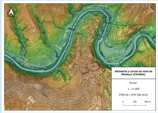
In order to be able to present this discipline, the methodology and the different practical applications it presents, we must frame the structures and elements we want to use as examples. This is why we wanted to use the current Cerro de Palomarejo as a structural, topographical and geographical element characteristic of the city1. The town of Montoro currently occupies the entire isthmus generated by the meander of the river Guadalquivir. This isthmus is partially isolated, as at its connection with the southern bank of the river Guadalquivir we can see the Cerro Palomarejo (Figure 1). This hill has been the subject of numerous studies and historical debates, both in past centuries and nowadays, mainly motivated by the findings in the area known as Llanete de los Moros. The oldest finds found in this area, in general terms and without being the object of our work the analysis of these materials or their chronological debate, are framed in the beginning of the Final Bronze Age in the middle basin of the Guadalquivir. Some of the materials in this archaeological context, recovered during the excavations carried out at the end of the 20th century, yielded interesting results related to the field of Central-Mediterranean trade. Some works have been carried out with the aim of determining a complete stratigraphic sequence, or with the intention of providing more data on the context of the indigenous settlements that inhabited this area during the Final Bronze Age [2-6]. By way of a brief conclusion, then, we can see the large amount of archaeological data on human occupation that this hill provides us with, even before the arrival of the Roman contingents.
Foot Notes
1 We are grateful for the interesting information provided by José Ortiz García on the recent history of Montoro and his comments on the different changes that the Cerro de Palomarejo and its surroundings have undergone. We would also like to highlight the availability and information provided by Francisco Aguilar Pérez. People who are passionate about history, who disseminate and enhance the value of historical and cultural heritage are more than necessary nowadays.
The accession of the ancient city of Épora2 as a confederate city of the Roman Republic around 206 B.C.E., together with other cities of great importance such as Gades [7], materialises the importance of this city already in Roman times. This fact shows us the historical and archaeological relevance of the remains that can be found in its immediate surroundings. Evidence of this are the large sculptural pieces, the abundant pottery and the large number of constructive elements recovered and deposited in national, provincial and municipal museums. These data are added to the already interesting natural location of the city of Épora, located between the mountains and the countryside, which allowed for a multi-purpose economy, also situated at a crossroads [2], with the famous Via Augusta even passing through the gates of the city [8-10]. All the data presented in this brief summary of the different historical-archaeological investigations of the remote past of the town of Montoro speak to us of the great importance of this strategic enclave, as well as the importance of its highest promontory, the Cerro de Palomarejo. This is why we wanted to make it the focus of our topographical study and analysis, as well as an example of the practical application of a palaeotopographical recreation, using the different tools provided by Virtual Archaeology.
The historical recreation of the Cerro de Palomarejo
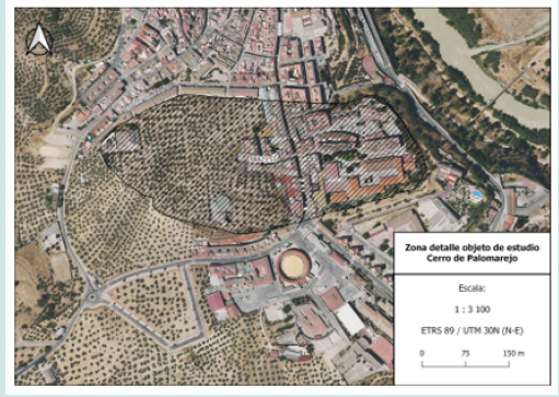
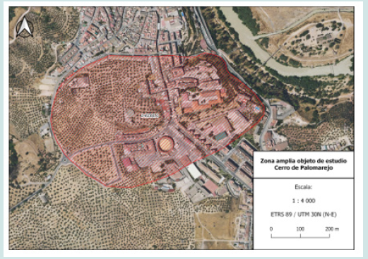
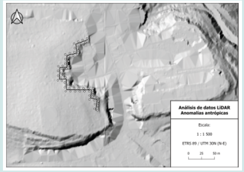
In order to undertake a correct recreation of the palaeotopography of the hill, we have implemented LiDAR3 technology as a practical means to analyse the territory of the hill itself and the surrounding area, as well as the information provided by GIS4 on the structure and eventual destruction of the promontory. This spatial analysis has resulted in interesting questions. Firstly, it has provided us with a clear image of the spatial delimitation and the surface of the hill, both of its highest area (Figure 2) and of the whole of the beginning of the promontory (Figure 3). With this data, we have been able to spatially limit the impact to be carried out in the recreation of the topographic environment of the hill, as well as the height that the natural terrain of the hill could present. Next, once the area affected had been delimited, we proceeded to interpret the damage that the passage of time, and mainly modern urban development, has caused to the morphology and dimensions of the hill. Thanks to the information provided by the LiDAR data, we have been able to observe the different anthropic anomalies of quadrangular shape that have generated a kind of “bite” in its morphology. Not only for modern constructions, but also for the articulation of a direct communication route between the interior of the isthmus and the exterior, “cutting” the Cerro de Palomarejo and shaping it as two independent promontories (Figure 4).
Foot Notes
2 It is more than plausible to point out the pre-Roman origin of the name Épora, which must have variants such as Aipora and even Ebora. Other authors suggest the Celtic or even Ibero-Turdetan name of the toponym, which could be of Indo-European origin, as it has the prefix “Hipo-” or “Ip-” (Rodríguez Neila, 1990: 217).
3 LiDAR stands for Light Detection and Ranging. It is a device that allows to determine from a laser emitter to an object or surface using a pulsed laser beam. The distance to the object is determined by measuring the time delay between the emission and its detection. These data can be consulted and downloaded free of charge from the National Geographic Institute.
4 Geographic Information Systems, or GISs, are systems that create, manage, analyse and cartographically represent all types of data. All the data consulted in this work are available at the National Geographic Institute.
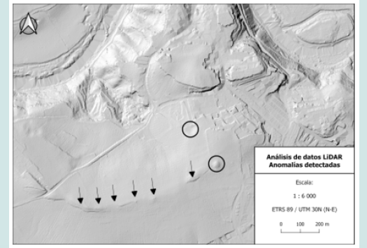
Likewise, the analysis of the different anomalies found thanks to the LiDAR data led us to consider different hypotheses about possible constructions, relatively distant from the hill but which may have had some kind of relationship with it. After consultation with specialists in the field, we confirmed that these anomalies were indeed part of an anthropic building, whose historical ascription is yet to be determined5 (Figure 5). In the LiDAR data we were able to clearly observe the development of the Roman road on the west side, and we were able to draw an interesting reconstructive hypothesis of its route as it passed through the gates of Épora, although it was not the object of our study. Other interesting data provided by the LiDAR technology are those observed in the immediate surroundings of the hill. In the area corresponding to the Guadalquivir riverbed as it passes through the isthmus, there is a small promontory. This can still be seen today, although it does not form an islet. Its constitution as an islet in the middle of the river only occurs during the seasonal flooding of the Guadalquivir. However, when the level of the flow of the river rises slightly, and as a possible reconstructive hypothesis of the palaeolandscape, the riverbed expands to form this interesting geographical feature, which is worth studying in depth to determine whether or not it is of anthropogenic origin.
Virtual Archaeology as a tool for historicalarchaeological recreation
the data provided and analysed by LiDAR result in a series of geospatial anomalies that have had to be addressed, either to recreate them or to eliminate them because they belong to later phases or directly to human constructions. Virtual Archaeology is a discipline that, although it has not been around for many years, has a long academic background. Developed by Professor Demetrescu’s team, it is articulated as a present (and future) proposal for the development of virtual reconstructions and recreations of a historical-archaeological nature with a high scientific traceability [11,12]. Having delimited the areas of anthropic affection, with the help of the Blender software, and using the digital sculpting tool, we have reintegrated the missing parts of the Cerro, as well as smoothed or directly eliminated the affected areas. Once we have collected all the data provided by the GIS, and thanks to LiDAR technology, we have been able to compile a sort of list of all the elements that need to be addressed in order to recreate the morphology of the Cerro de Palomarejo palaeotopographically. First of all, we must eliminate the different buildings that generate distortion in the model, namely those built in the immediate vicinity, as well as the roads and current accesses to the municipality. Next, we must clearly define the effect of the different modern “bites” that must be “filled in” with the aim of forming a single hill as it should have been in the past. Finally, and with the intention of integrating the surroundings into this recreation of the landscape, we have tried to correct the errors emitted by the LiDAR in the historic centre of the current municipality, partially recreating in a hypothetical way the relief which, in the absence of extensive geological and geomorphological studies of the isthmus, provides a plausible visual of this natural element.
Foot Notes
5 Still to be studied and analysed specifically by its researchers.
Figure 5: Anomalies detected in relation to the motilla culture in the area around Cerro Palomarejo.
Conclusion
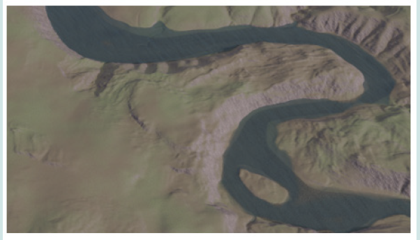
We would like to stress that this work has not been carried out taking into account the interesting discipline of Landscape Archaeology, nor the cultural landscapes characteristic of this area. We simply wanted to recreate the Cerro de Palomarejo without any type of human occupation, with the intention of understanding its morphology and dimensions. The results of this recreation (Figure 6) generate a more than close approximation to the specific morphology of Cerro Palomarejo, even taking into account that the possible effects on it of the different structures that must have been formed during the different human occupations that altered it are not included. We consider it essential that the implementation of these tools be carried out prior to undertaking a historical recreation of a specific city or geographical space. To this end, it will be necessary to improve the analytical and reconstructive capacity through geospatial and geoarchaeological studies, which will help to determine the historical evolution of the study area, and thus obtain better reconstructive hypotheses of the same.
Figure 6: Recreation of the palaeotopography of the Cerro de Palomarejo and its natural environment.
References
- (2017) The Principles of Seville. International Principles of Virtual Archeology. ICOMOS.
- Baquedano Beltran I (1987) Inicios del Bronce Final en la cuenca media del Guadalquivir: El Llanete de los Moros (Montoro, Córdoba). Trabajos de Prehistoria 44(1): 223-250.
- López García P, López Sáez JA (1994) Estudio palinológico de los sedimentos arqueológicos del yacimiento del Llanete de los Moros (Córdoba). Trabajos de Prehistoria 51(2): 179-186.
- Martín de la Cruz JC (1979) Montoro, un nuevo yacimiento arqueológico en el Guadalquivir. Cuadernos de Prehistoria y Arqueología 5.6(1979): 1-37.
- Martín de la Cruz JC (1987) El Llanete de los Moros. Montoro, Có En Excavaciones arqueológicas en España. Madrid: Ministerio de Cultura. Dirección General de Bellas Artes y Archivos.
- Martín de la Cruz JC, Lucena Martín AM, Liébana Mármol JL (2001) Excavación arqueológica de urgencia en el Llanete de los Moros (Montoro, Córdoba). Anuario Arqueológico de Andalucía, 2001, III Actividades de Urgencia 1(3): 321-327.
- Rodríguez Neila JF (1990) Problemas sobre la protohistoria y romanización de la antigua ciudad de Epora (Montoro). Brac 118(1): 199-255.
- Melchor (1995) Vias romanas de la provincia de Có Córdoba: Publicaciones de la Obra Social y Cultural CAJASUR.
- Melchor Gil E (1991) Camino romano entre Montoro y el Valle de los Pedroches: La vía Epora-Solia. III Encuentros de Historia Local. Alto Guadalquivir (Montoro, 11 y 12 de enero de 1991) pp. 79-86.
- Peña Villaverde JA (2017) AAP en la modalidad de control arqueológico de movimiento de tierras en el emplazamiento Camino de los Bermejales (Antigua Vía Augusta) en Montoro (Córdoba). Anuario Arqueológico de Andalucía 2017. Recuperado de.
- Demetrescu E (2015) Archaeological stratigraphy as a formal language for virtual reconstruction. Theory and practice. Journal of Archaeological Science 57(1): 42-55.
- Demetrescu E, Fanini B (2017) A white-box framework to oversee archaeological virtual reconstructions in space and time: Methods and tools. Journal of Archaeological Science: Reports 14(2): 500-514.

Top Editors
-

Mark E Smith
Bio chemistry
University of Texas Medical Branch, USA -

Lawrence A Presley
Department of Criminal Justice
Liberty University, USA -

Thomas W Miller
Department of Psychiatry
University of Kentucky, USA -

Gjumrakch Aliev
Department of Medicine
Gally International Biomedical Research & Consulting LLC, USA -

Christopher Bryant
Department of Urbanisation and Agricultural
Montreal university, USA -

Robert William Frare
Oral & Maxillofacial Pathology
New York University, USA -

Rudolph Modesto Navari
Gastroenterology and Hepatology
University of Alabama, UK -

Andrew Hague
Department of Medicine
Universities of Bradford, UK -

George Gregory Buttigieg
Maltese College of Obstetrics and Gynaecology, Europe -

Chen-Hsiung Yeh
Oncology
Circulogene Theranostics, England -
.png)
Emilio Bucio-Carrillo
Radiation Chemistry
National University of Mexico, USA -
.jpg)
Casey J Grenier
Analytical Chemistry
Wentworth Institute of Technology, USA -
Hany Atalah
Minimally Invasive Surgery
Mercer University school of Medicine, USA -

Abu-Hussein Muhamad
Pediatric Dentistry
University of Athens , Greece

The annual scholar awards from Lupine Publishers honor a selected number Read More...


