Lupine Publishers Group
Lupine Publishers
Menu
Research Article 
The Eighth Wonder of the World in New Zealand-the Black Terrace Discovery Volume 1 - Issue 2
A Rex Bunn*
- Independent Researcher, Caves Beach, NSW, Australia
Received: July 10, 2023 Published: August 29, 2023
Corresponding author: A. Rex Bunn, Independent Researcher, Caves Beach, NSW, Australia
Abstract
This research to locate the lost Black Terrace was motivated by scientific, lay, and indigenous tourism interest in the Taupō Volcanic Zone in New Zealand, wherein lies buried a lost Eighth Wonder of the World, the Pink, Black and White Terraces. The Black Terrace was undocumented until 2017 and its location was unknown. This paper compiles evidence to relocate the Black Terrace site, so that site investigation may be undertaken, to recover siliceous sinter terrace material for chemical and textural analysis. This research triangulates the location, relative to the companion Pink and White Terraces; via spatial, georeferencing, survey resection, Mātauranga Māori, photogrammetric-optical, trigonometric, cartographic, and topographic evidence; over Google Earth™. The evidence triangulates with the Black Terrace lying beneath a forestry road, providing sub-surface imaging, drilling, and excavation access. Given the 2021 ownership change of the site and the nearby tourism projects; this research has considerable significance for the new indigenous owners of the Black Terrace. It has broader implications for investigating and potentially recovering the Pink and White Terrace sites.
Keywords: Black Terrace; Black Terrace Crater; Pink and White Terraces; Mātauranga Māori; topography; Rotomahana Basin; Tarawera eruption
Introduction
In the nineteenth century, the foremost tourism and geoscience attraction in the southern hemisphere were the siliceous Pink and White Terraces, the lost Eighth Wonder of the World in New Zealand. This research addresses the geolocation of a third Black Terrace, to assist relocation of the companion Pink and White Terraces. In 1886, the Mount Tarawera eruption created a large crater near the Terrace locations. It also buried the Terraces. Colonists assumed the Pink and White Terrace locations lay in the crater. In the absence of a government survey or evidence of their locations or destruction, debate over their survival continued until the 1940s. In 2011, a joint New Zealand-American project claimed to have found the Pink and White Terraces underwater in the new crater Lake Rotomahana (de Ronde et al [1-3]). Recently their claims were refuted (Bunn [4-6]). By this time the third, Black Terrace had long departed the historical narrative. This paper restores it to the scientific record using novel interdisciplinary methods.
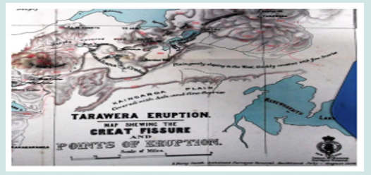
The only large-scale maps of pre-eruption Lake Rotomahana, on the left-side map border, accommodate a terrace named Te Ngawha Atetuhi or Te Tuhi’s Spring (Johnston & Nolden [7]; Hochstetter & Petermann, [8]). Refer to (Figures 1 & 2). Our research takes place in what is termed the Rotomahana Basin, within the Taupō Volcanic Zone in New Zealand. This compact basin featured a pre-eruption central, north-south ridge: the Steaming Ranges, named by Daniel Mundy (1826-1881), (Mundy [9]). The Māori name is unrecorded. A lake lay on either side of this ridge, forming an m-shape i.e., Lake Rotomahana to the west and Lake Rotomakariri to the east. A small flat lay beyond each lake. These ended in the east, against the Tarawera massif and on the west against Kumete Ridge. The distance across the basin was seven kilometers at the nearest point. Within this basin lay >125 geothermal features, many distinguished as tourist attractions for the global audience. The White Terrace lay on the northwest tip of the central ridge. The Pink Terrace lay on the west shore of Lake Rotomahana. The Black Terrace lay on the western flat between the Pink Terrace and Kumete Ridge.
The proximity of the many geothermal features in such a small basin, and the enormous crater formed by the 1886 eruption, help explain why later researchers drawing inferences and sightlines on pre-eruption photography often made Type I statistical errors. With bearing errors of ≤7° (when survey accuracy requires ±1°-2°, McFadgen [10]); then target fixation became an issue (Hook [11]). The recent discovery of a unique terrestrial survey of the Basin overcomes this problem and enables the Terrace locations to be recovered (Bunn and Nolden [12]).
Literature Review
The first formal literature review of the Black Terrace was made only in 2017 (Bunn [13]). The first mention is by Ferdinand von Hochstetter (1829-1884) in his 1859 survey, in (Figure 1). Te Ngawa Atetuhi, translated as Te Tuhi’s Spring (and later confused with Black Terrace Crater) was one of three hydrothermal Terrace attractions around old Lake Rotomahana. His entry was first translated and interpreted in 2017 by Rangitihi Pene, Chairman of the Hinemihi Marae and I viz: From the preceding words Te Ngāwhā. Te Tuhi is most likely a person’s name (the sentence indicates Te Tuhi is a noun), (pers. comm., R. Pene to R. Bunn [13]). It was not always included on the nineteenth-century tours, because it was not as accessible as the Pink and White Terraces. The first western description is also by Hochstetter who visited Te Tuhi’s Spring, sketched, and painted it, and included it on his 29-30/4/1859 maps at the lake: “A little beyond the lake, in a small side-valley, lies the Atetuhi; (Hochstetter [14]). That it was a significant Terrace is attested by its inclusion on the 1861 map by Petermann, requiring a border extension to accommodate it. Hochstetter sketched Te Tuhi” s spring in a watercolor, (the only known illustration). He depicts Te Tuhi’s Spring as similarly sized to the Pink Terrace (Te Otukapuarangi) but with a shorter, tapered terrace. The single spring is in an elevated basin, with a platform oriented east-southeast and surrounded by an embankment on three sides, open to the east. There is an unnamed outlet stream draining along a valley, lying east-southeast and emptying into the old lake north of Te Whakataratara. The spring-to-lake shore distance was reportedly ~400 m (Thomas [15]). No photographs or artwork records have been located of the spring and terrace. It was cited in later colonial literature as the Black Terrace, due to the darkcolored silica sinter produced by the spring. The Terrace vanished from colonial literature until the 1886 Rotomahana eruptions when colonists associated the final stage of the eruption with the area of the Terrace. It is noted that due to landform changes during the eruptions and the lack of survey coordinates, it was judged impossible by Stephenson Percy Smith (1840-1922) in his official 1887 eruption report, to locate any of the Terraces with certainty (Smith [16]).
Prof. Algernon Thomas (1857–1937) made 1886 notes on the Black Terrace, confusing later investigators by associating it with the Black Terrace Crater: Mr. Lundius and the writer, whilst travelling over the mud around the Rotomahana Crater on the 21st of July, noticed at one place, about a quarter of a mile from the edge of Rotomahana, steam issuing with hissing noise from cracks in the mud. A fortnight later a survey party observed large clouds of steam rising from the spot, and, on approaching, it was found that a new crater had been formed, which was throwing out stones and mud with great vigour. This crater was about 200 yards or so in diameter and occupied the position of the Atetuhi Geyser, known also as the Black Terrace, from the colour of some of the sinter there. This crater, the last which was formed during the eruption, was therefore called the Black Terrace Crater. It continued in active eruption for two days, and, with less energy, for some weeks longer. The formation of the Black Terrace Crater was the last considerable event in the eruption so far as the subterranean forces were concerned; the changes which have since occurred in the craters are due rather to agencies acting at the surface, (APW Thomas [15]). Surveyor S.P. Smith noted the formation of Black Terrace Crater thus: a little circular crater-like lake …situated approximately on the former site of the Black Terrace, a group of hot springs., the deposit of which was dark in colour...On the 31st of July the birth of another crater on the site of the Black Terrace, which increased in size to an eighth of a mile in diameter, and sent up a column of steam (Smith, [16]). He also noted: At a location about 200 meters northwest of the confines of Rotomahana Crater a significant hydrothermal eruption occurred between 31 July and 6 August 1886 and continued until at least 15 August. Smith named the new vent ‘Black Terrace Crater’ … after a small pre-eruption hot spring situated approximately at its site (Smith [16]).
Ron Keam (1932-2019) in 2016 commented on Black Terrace Crater: Almost certainly this event is explicable in terms of falling pressures in the hidden part of the Rotomahana geothermal system at this locality – a relatively short distance back from the Rotomahana Crater edge – and caused by the sinking water table as ground water gradually percolated through to that deep and essentially empty neighboring basin No definite surface expression of this feature has unambiguously been recognised, so we have felt it safest not to indicate its tentative location,[Keam did record a position in the paper, one which proved accurate], (Keam and Lloyd, GOSA [17]). A newspaper account was published in 1887: Retracing our steps we pause at the lips of the Black Terrace Crater. This one was the last in action and had just burst out as Mr. Smith left the field on his last visit. The proper name of this, as it is laid down in Hochstetter’s chart, is ‘Te Ngawha Atetuhi,’ then only a little boiling spring, but now several acres in extent. The Black Terrace Crater is quite a misnomer, as there is nothing black about it, or any signs of a terrace formation whatever. The upheaval here must have been very great. Numerous boulders and stones of all colour and descriptions lie scattered about in all directions. We picked up some fine specimens here, amongst which were lumps of petrified wood and charcoal.’ (New Zealand Herald, 1887). In 1911, Leys related the July 1886 findings: ‘On the 28th of July the survey party noticed a small pool of muddy shallow water, a small jet of steam arose some 20ft or 30ft On the 31st of July two heavy shocks…On the 5th August a great change was noticed…A great cloud of steam… while stones and mud were cast up to great heights…a new crater had been formed about an eighth of a mile in diameter, but of what depth…Large quantities of water were thrown out together with the more solid material…Black Terrace Crater…occupies approximately the same position of the former solfatara, the sinter deposited by which was dark in colour. Up to the 15th of August it continued to be one of the most active points…’ (Leys, 1911). From 1859-1886, there is passing mention of the Terrace in tourist accounts (Bunn [13]). From 1886-1911, the Black Terrace and its later analogue, Black Terrace Crater seeped from maps and the scientific record
In 2017, the PAWTL2 Project (Pink and White Terraces II Project) was launched in response to global interest, following the discovery and publication of a unique, pre-eruption terrestrial survey by Ferdinand Hochstetter of the Rotomahana Basin, including the three terraces (Bunn & Nolden [12]). PAWTL2 collated indigenous Māori and Western history with field research including the Black Terrace, into the seminal report published in 2017. It concluded the colonists had confused a post-eruption feature they named Black Terrace Crater with the pre-eruption nearby siliceous Black Terrace (Bunn [13]). The Black Terrace now assumed importance, for it lay buried on land outside the 1886 crater. Given the relative locations of the three Terraces mapped by Hochstetter and with new survey evidence of the Pink and White Terraces from his survey-the Black Terrace location could act as a spatial datum: to triangulate the locations of the other two terraces. If the Pink and White Terraces also lay outside the 1886 crater, they may no longer be assumed destroyed. They might prove recoverable. In 2014, it was estimated that if the terraces could be recovered-inbound tourism would surge by a million tourists over five years (Bunn [18]).
A member of the PAWTL2 team later returned to the Black Terrace Crater site conducted sub-surface imaging, located evidence of the crater, and suggested the lost Black Terrace lay in it (White [19]). This paper provides evidence confirming his imaging is from the Black Terrace Crater location. It discloses the true location of the Black Terrace nearby, based on spatial, survey, trigonometric, cartographic, photogrammetric, topographic and artifactual evidence. Given the nineteenth-century Pink and White Terraces’ tourist boom, finding the Black Terrace now takes on great economic, cultural, and scientific significance. The quest for the Black Terrace takes its place with many other examples of lost and recovered.
landscapes, which have societal importance. Some the author visited include. e.g., Salisbury Plain around Stonehenge in England and Lake Manapouri in New Zealand. The Save Manapouri Campaign led to the abandonment of a hydroelectricity scheme on Lake Rotomahana. For an Australasian audience, the evidence supporting the Pink, Black and White Terraces is inestimably stronger than for example-Lasseter’s Reef.
Methods and Data
Cartography and georeferencing
Two large-scale maps of the Rotomahana Basin were published before the 1886 Tarawera eruption. These are by Hochstetter in 1859 in (Figure 1) (published by Nolden in 2011) and Hochstetter and Petermann in 1864 in Figure 2 (Johnstone & Nolden [7]). In 2013, Nolden also published two drafts, large-scale Hochstetter Lake Rotomahana maps (Nolden & Nolden [20]). Hochstetter’s site maps have the virtue of
being drawn beside the lake by a qualified draughtsman and geoscientist, versus Petermann’s 1864 map drawn sight unseen in Gotha, with significant defects (Bunn [13]). In 1887, S. P. Smith published the first post-eruption map of the Rotomahana Basin. (Smith [16]). In 2021, his field sketch version also entered the public domain (Smith [16]). The four, large-scale pre-eruption Hochstetter maps were georeferenced over Google Earth, after Hochstetter’s primary and secondary survey stations were resected, as control points, using reciprocal bearing loci. The aspect ratio of the maps was of course preserved. The georeferenced Terrace spring locations and other key landmarks were located along Hochstetter’s survey bearings, validating the georeferencing, trigonometry and photointerpretation.
Survey Resection
The only pre-eruption survey of the Rotomahana Basin was by Hochstetter in 1859. Dr Sascha Nolden transcribed and translated Hochstetter’s survey notebooks relating to the Rotomahana Basin. The author and Nolden began reverse engineering the bearing data in a series of papers: to first locate the primary and secondary survey stations and then to respect the Pink and White Terrace locations using Hochstetter’s bearings and stations (Bunn & Nolden [12]). In 2020, Nolden provided the complete 1860 survey Folio tranche to the author, and we reconstructed Hochstetter’s entire North Island survey of 664 bearings and culminating in the Rotomahana Basin. The Terrace data sources are consistent, and the Folio reconstruction is currently in review (Bunn & Nolden [12]).
Spatial and topographic
The author’s 2014 PAWTL1 and 2017-2018 PAWTL2 field and desk research in the Rotomahana Basin, includes the only scuba exploration of the lake floor in 2016. After assembling the Mātauranga Māori, historical, lay and scientific records over 2014- 2023; an interdisciplinary overview of the Basin architecture was obtained, enabling these triangulation methods to be integrated (Bunn [21]).
Mātauranga Māori contribution
The PAWTL1 and 2 projects at Rotomahana were facilitated by active support from the Arawa sub-tribe Tūhourangi, which traditionally claims the terrace lands. The contribution from Mātauranga Māori (traditional Maori knowledge) is pivotal in our understanding of e.g., Rotomahana Basin nomenclature and photointerpretation.
Photointerpretation, Photogrammetry and Photogrammetric Optics
After the 1886 eruption, the only records of the pre-eruption basin were oral, artistic, and photographic. Given the artistic Licence taken by artists, photography became the sole visual record for later researchers. Unfortunately, the development history of nineteenth-century photography in New Zealand wasn’t written until 1971, when all Terrace photographers were dead and technical knowledge of their photography and equipment was lost (Knight [22]). Unlike other researchers, the author has formal qualifications in film and cassette photography. This led to the first published technical analysis of nineteenthcentury New Zealand and Rotomahana Basin photography (Bunn [23]). That analysis exposed the embellishment and fakery applied to Pink and White Terraces prints and slides by commercial photographers: motivated to maximize their print sales. Such darkroom Licence damages the evidentiary scientific value of Terrace prints employed by recent researchers: leading to speculative claims (Keam [24]). Due to the narrow range of viewpoints available to Terrace photographers and the technical limitations of their wet and dry plate technologies; photogrammetry per se cannot be applied to Pink and White Terrace photography (pers. comms. C. Fraser, Photometric (2016-2018). Some surviving prints however are amenable to analysis by photogrammetric optics and this are first undertaken in this paper, around the Black Terrace.
Trigonometry
Given the relative positions of the georeferenced, mapped, and surveyed Terrace spring locations-these were further triangulated using trigonometry i.e., by the Sine Rule. This rule relates the sides of a triangle to the signs of its angles. The three Terrace locations, (the spring centers best form a terrace datum) are joined by rays forming a scalene triangle. The Pink and Black Terraces plus Black Terrace Crater form a second triangle. The Sine Rule calculates the inter-terrace distances from e.g., two angles and one ray, based on the cartography and survey data.
Artifacts
Most siliceous sinter found around the Rotomahana Basin is white when dry. The Black Terrace was so named for its dark sinter colour. Over 2016-2018, the author and colleagues made extensive searches near the three Terrace sites, as then reported. Sinter was also collected from the lake floor, after research claims the Terraces lay on the lake bottom (de Ronde [1-3]). XRD (X-ray diffraction) failed to confirm any dark rock samples were Black Terrace sinter at that time. In 2023, one dark sample remains to be tested:
(https://app.geosamples.org/uploads/files/IEREX/ IEREX0003_DSCF4604Z.JPG).
Results
Cartography and georeferencing
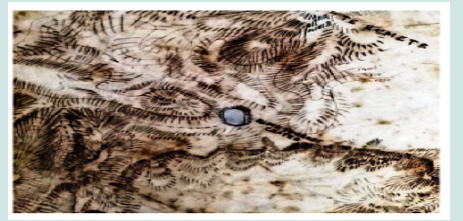
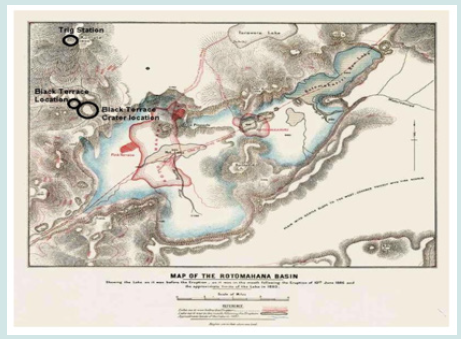
Ferdinand von Hochstetter first documented, surveyed and mapped three peerless, siliceous sinter terraces at Lake Rotomahana in 1859. In 2016, the efforts by Hochstetter and Petermann to include a terrace on their left map borders (at nine o’clock), named Te Ngawha Atetuhi (Te Tuhi’s Spring) were noted in (Figures 1 and 2) (Bunn & Nolden [12]). Recently, the 1886 sketch map of the Rotomahana Basin by Smith entered the public domain and the segment showing the Black Terrace site and Black Terrace Crater is in (Figure 3).
Figure 1: Hochstetter’s third and final 30/4/1859 large-scale map of Lake Rotomahana, drawn beside the lake (Hochstetter Collection Basel, 3.5.10).
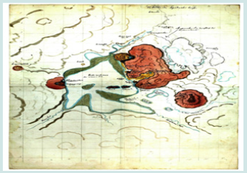
Figure 2: Map of Lake Rotomahana from the English edition of Hochstetter & Petermann’s Geological and Topographical Atlas of New Zealand – Te Ngawha Atetuhi is outside the left border (Hochstetter & Petermann, 1864).
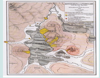
Figure 3: Segment of S. P. Smith’s unpublished 1886 sketch map of Rotomahana crater, showing Black Terrace Crater, approx. 400 m from the crater edge at the exit of Black Terrace Stream. Alexander Turnbull Library, MapColl-r832.18cba/1886/ Acc.57114.
Survey resection
This research from 2016-2020 relied on the first translation of Hochstetter’s 1859 survey diary and his 1867 book (Hochstetter [22]). The 2020-2023 research draws on his newly transcribed and translated unpublished 1860 survey Folio. This compiled his complete 1859 North Island terrestrial survey data, for publication by August Petermann at the leading European cartographers Justus Perthes. The more extensive compiled Folio data are consistent with the diary data. The Folio elaborates on the expedition, survey methodology, error, and survey stations. A paper reporting the Folio survey resection is currently in review (Bunn & Nolden [12]). No changes to the 1859 survey stations, landmarks or bearings were required by the Folio data. The published survey Iterations V-VI herein, remain valid (Bunn [6]).
Spatial and topographic aspects of the black terrace
Included in the 1870-1886 tourism literature, there was mention of a Black Terrace. While there was uncertainty over whether the Pink and White Terraces lay on land or water, there is no doubt about the Black Terrace. It is located on land and was buried by eruption ejecta and erosion. Hochstetter described it thus: ‘A little beyond the lake, in a small side valley, lies the Atetuhi; (Hochstetter [25]). In geomorphology, the term side valley has a precise meaning i.e., a valley close to mountains and with a low strahler order. The terrace formed from a spring, and this formed a stream; a first-order Strahler stream (NSW Dept. of Industry, 2018). To be sure, Dr Sascha Nolden checked Hochstetter’s nineteenthcentury German (S. Nolden [12]). He used the term Seitental, (also known as a Nebental). These terms have the same meaning in present-day English. I examined the first-generation photography of Hochstetter’s manuscript maps of Lake Rotomahana and discerned the topographic detail around the Black Terrace. He drew a ridge above and around the terrace, forming a short, side valley debouching into the south side of a larger valley that drained (and still drains) Kumete Ridge into the lake. This larger valley thus has a second or possibly third-order Strahler stream, referenced here as the Black Terrace Stream. Given Hochstetter’s pre-eruption cartography, finding this Terrace could enable the triangulation of the Pink and White Terraces. In 2017, the PAWTL2 Project launched in response to global interest and the Black Terrace and Crater were marked for field research. The seminal documentation on the Terrace and Crater was published that year (Bunn [4]). This collated Mātauranga Māori and Western history with previous research. The Black Terrace is the most accessible of the three terrace locations.
Mātauranga Māori view
From the 2017 PAWTL2 report, it was clear colonists confused the Black Terrace Crater with the Black Terrace. The findings here confirm this. Given eruption landform changes and the lack of a survey in 1886, no colonist could specify any of the terrace locations and they were presumed lost. The Māori view was canvassed among tribal elders by Ngāti Rangitihi guide Alfred Warbrick (1860–1940). These Arawa elders, with superior topographic mapping knowledge to the colonists; all insisted the Pink and White Terraces survived the eruption and were buried in mud (Warbrick [26]: (Bunn [27]). The Black Terrace must also lie buried. This research verifies their judgement.
Black terrace crater and black terrace ma
p and photograph interpretation
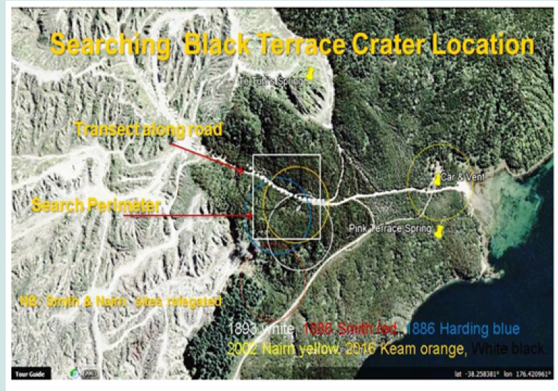
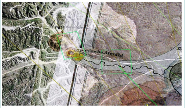
The 2017 PAWTL2 report published six recorded Black Terrace Crater locations (Bunn [5]). These were narrowed to four and the search field and transect in (Figure 4) were agreed upon (pers. comm.: R. Bunn to P. White [19]). In 2017, under survey iteration IV the terrace was believed to lie north of this, but in 2019 with iteration V, it was seen to lie northwest of the Crater search field (Bunn [28]). The published 2018-2019 iterations V-VI of Hochstetter’s survey plotted the location of the terrace spring ~300m from the Crater field in (Figures 4 & 5) (Bunn [28]). Iteration IV of Hochstetter’s survey was developed in 2017. Iterations I-II were unpublished working drafts, with Iteration III first published in 2016 and IV in 2017 (Bunn & Nolden, [12]). Following auditing by surveyors Nick Davies and David Stewart of Cheal Consultants, a landmark error on the Tarawera massif (i.e., composed of Wahanga, Ruawahia and Tarawera peaks); was recognised and reported (Bunn [13]). That led to Iterations V-VI which inter alia corrected the Black Terrace location to the forest road adjacent to the Crater. In (Figures 4 & 5) the Crater search field lays center-to-center ~300 m from the terrace field. The search fields are ≤80 m apart. Ironically, the PAWTL2 Project team drove over both sites: walking the Crater field and collecting black rocks for X-ray diffraction. Both search fields are shown and the Black Terrace from Hochstetter map georeferencing in (Figure 5) (Bunn [28]).
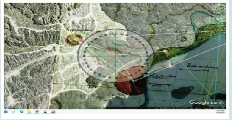
Figure 5: Black Terrace (left) and Crater (right) search fields, as green boxes. Hochstetter’s 1859 map is overlaid (Bunn, 2019b).
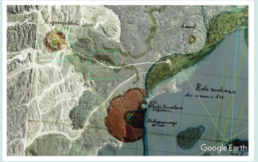
The eyewitness record shows the Crater grew to ~180 m (~200 yds.) diameter with an area of ~2.5 ha. It lies northwest of the main 1886 Rotomahana eruption crater. The estimated center of White’s site lies ~400 m from today’s lake shore. This is consistent with reports that the Crater was ~400 m from the Rotomahana crater (Thomas [15]). Boat Launch Bay had an eruption vent and chronic erosion since 1886. These obscure the 1859 exit of Black Terrace Stream, as with the Kaiwaka Stream further to the north. The Black Terrace lies nearly 200 m further inland on Hochstetter’s survey and mapping (Figures 6-8).
Figure 7: The Black Terrace of the Kereru Geyser, c. 1910, (Whakarewarewa. Rose Archives, SUNY Brockport, Brockport, NY).
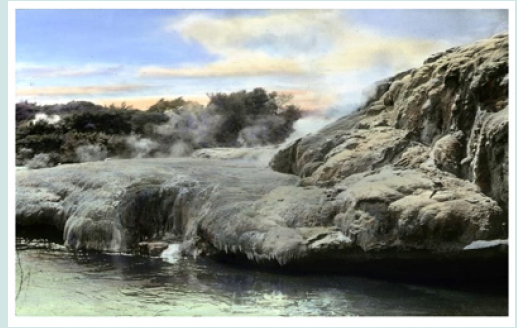
Figure 8: Segment of S. P. Smith’s 1886 map of the Tarawera area showing Te Kumete and Black Terrace Crater (Smith, 1886. Photograph by author).
Triangulating the black terrace location with trigonometry
Figure 10: The Black Terrace of the Kereru Geyser, c. 1910, (Whakarewarewa. Rose Archives, SUNY Brockport, Brockport, NY).
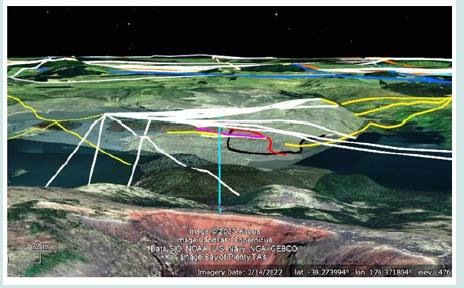
Figure 11: Segment of S. P. Smith’s 1886 map of the Tarawera area showing Te Kumete and Black Terrace Crater (Smith, 1886. Photograph by author).
The only records showing both Black Terrace Crater and Black Terrace are (Figures 9-11): (with the caveat the ponding over the predicted Black Terrace location cannot be proven to lie above the terrace without excavation). Hochstetter’s and Petermann’s mapping is compared with triangulation by the Sine Rule in (Figure 6). The mapped distances are:
a) Black Terrace-Pink Terrace = ~714 m Hochstetter and ~713 m Petermann.
b) Crater-Pink Terrace = ~340 m Hochstetter and ~466 m Petermann.
c) Black Terrace-Crater = ~404 m Hochstetter and ~311 m Petermann.
d) Black Terrace-White Terrace = ~1,609 m Hochstetter and ~1,489 m Petermann.
e) By Sine Rule these distances are:
f) Black Terrace-Pink Terrace = ~748 m Hochstetter and ~728 m Petermann.
g) Crater-Pink Terrace = ~346 m Hochstetter and ~475 m Petermann.
h) Black Terrace-Crater = ~435 m Hochstetter and ~324 m Petermann.
i) Black Terrace-White Terrace = ~1,619 m Hochstetter and ~1,490 m Petermann.
There is reasonable precision with the mapping and trigonometry to confirm the inter-terrace triangle distances (a, d, e, and h). There is less agreement regarding the Crater-Terrace triangle distances (b, c, f and g). There are gross errors in the intermap distances (b and c) and with the calculated distances (f and g). These cannot be explained by earth curvature or slope. The Petermann map has 12 known defects, and these contribute to the variance (Bunn [29]). Also, there is an ambiguous solution for the Crater triangle, and it is not possible to unequivocally triangulate the reported Black Terrace Crater location by the sine rule. However, the cartographic analysis herein answers the central question i.e., is the Black Terrace inside the Black Terrace Crater or not? The Crater remains a quasi- proximal survey datum, given it appeared as the final Rotomahana Basin eruption phase. The proximal landmarks so far verified at Lake Rotomahana include Rangipakaru Hill (Patiti Island), Steaming Ranges (Tarata Peninsula), Te Kumete, the old and new lake inter-terrace shores, Station 21 and Puai Station. Quasicontrol points are now the Black Terrace Crater and Te Poroporo (Bunn [5]).
Triangulating black terrace, black terrace crater and kumete ridge
There are multiple post-eruption records showing Black Terrace Crater with one quasi-proximal landmark i.e., Te Kumete peak. An example is S. P Smith’s 1886 map in (Figure 8) (Smith [16]). This major peak along Kumete Ridge was used by Hochstetter as a key landmark for both his survey stations. It is noteworthy for reportedly maintaining its elevation after the eruption at 1,830 ft (558 m). No pre-eruption photography of this ridge has been found. Te Kumete is also marked on Petermann’s 1864 map. To test the positions of the Black Terrace and of Black Terrace Crater relative to Te Kumete, I georeferenced available cartography with Google Earth. The maps included Hochstetter’s 30 April 1859 map Petermann’s 1864 map, Smith’s unpublished 1886 sketch map, his 1886 and 1894 maps; and Harding’s 1887 map. On Google Earth, the azimuth from Black Terrace Crater (estimated centre) to Te Kumete is 347°±1°. It is the same azimuth on Smith’s and Harding’s 1886 and 1887 maps as well as on Smith’s 1894 map. Next, I georeferenced the Hochstetter and Petermann maps on Google Earth and measured the azimuth from Black Terrace Crater to Te Kumete. Both maps recorded 347°±1°, confirming sound mapping and georeferencing. On these maps, I then checked the azimuth from Black Terrace to Te Kumete. It is 358° ± 1° on Petermann and 5°±1° on Hochstetter; (the difference being expected given the known Petermann flaws which narrow the lake shape). The statistically significant variance between the Terrace and the Crater azimuths i.e., 11° with Petermann and 18° by Hochstetter, confirms the Black Terrace and Black Terrace Crater lie on discrete, vicinal locations. This establishes the Black Terrace does not lie in Black Terrace Crater, as White surmised (White [19]).
Black terrace dimensions
Some knowledge of the Black Terrace dimensions is necessary to e.g., gauge how deeply it is buried, both from the ground surface to the spring platform and to the base of the apron. This is problematic because we have limited descriptions from western visitors and no Mātauranga Māori record, save for the eponymous name Te Ngawa Atetuhi (Te Tuhi’s Spring) and we have no details of this person’s life or identity in the Tūhourangi history of the Rotomahana Basin. Siliceous sinter terraces are dynamic, evolving structures. The neighbouring Pink and White Terraces around Lake Rotomahana have several recorded estimates of their dimensions over a period of 30 years. During this time the terraces enlarged their footprints, especially the White Terrace, which was unconstrained; unlike the Pink Terrace confined in a narrow gully. As well, the colonial estimates of terrace dimensions vary according to the estimate method involved i.e., whether observational, geometric, by measured rope or a survey chain, stepping method or simply reiterating an earlier observation. Surviving records do not disclose the methods employed. The Pink and White Terraces also terminated in a small lake whose level varied by 1-3 m throughout the period, affecting terrace length.
Over nine years of searching, I found no verifiable photography of the Rotomahana Black Terrace, yet I remain confident some later photographer with a dry-plate camera, did venture up the Black Terrace Stream valley to capture this third Rotomahana Basin terrace. There are thousands of uncatalogued prints in the national collections and few investigators are technically qualified to identify them. Such surviving photographs of Black Terraces prove to be from similarly named features e.g., one outside Taupō and another smaller feature at Whakarewarewa in (Figure 7). This figure, having little resemblance to the Black Terrace; may nevertheless indicate the Black Terrace hue that was familiar to the colonists and Māori of the period. If so, the silica sample collected near the (later reported) Black Terrace site, is a good match for hue:
(https://app.geosamples.org/uploads/files/IEREX/ IEREX0003_DSCF4604Z.JPG Oddly, of all the samples collected by PAWTL2, this one is squared on four sides. While one face was deliberately cut by us, and one or even two can be said to reflect the laminar structure of silica deposition and fracture lines: the fourth square cut suggests it was not cut by natural forces but may instead be a mislaid tourist-cut sample from the Black Terrace. Western tourists were notorious for cutting terrace samples, along with graffiti. It is a useful retention sample for chemical and textural matching. The only evidence we have of the Black Terrace dimensions are the Hochstetter and Petermann mapping and Hochstetter’s notes on Te Ngawa Atetuhi.
For this first attempt at the Black Terrace dimensions, I studied geography and cartography, applying trigonometry to devise the estimated height and length. For the apron length, the two scaled maps agree at 83-84 m. The Black Terrace spring was elevated, like the Pink and White, and lay in a short side valley, surrounded by an embankment like the other terraces. Its orientation lay west-toeast with its spring forming a stream flowing east to the lake. For this first estimation, I referenced the slopes of the other terraces i.e., 6-11° for the White and 12-20° for the Pink (Bunn [28]). To match the artwork, I tried a range of gradients to fit the probable terrace rise with a run approaching 84 m. Slopes of 5°-20° contain the likely
rise range. The Terrace ages are unknown, for no core-drill samples were ever taken before the 1886 eruption. The Black Terrace is perhaps younger than the nearby Pink (given its mapped size and location): it is likely to be of lesser height and therefore lesser slope. For this first empirical approximation, I suggest the following dimensions: a height of ~15 m, a footprint of ~83 m and a slope of ~10°. These variables fit with a length of 84 m. If we presume an embankment height of ~5 m, then given the elevation and topography of the flat between the lake and Kumete Ridge, the altimetry for the terrace base lies between 310-315 MASL and the spring platform at 325-330MASL. Given the topography, the spring platform lies 30-35 m deep (Bunn [29]).
These dimensions illustrate the necessity of accurate empirical altimetry for the old Lake Rotomahana and the Terraces. This relied on guesswork (Keam [24]). The first evidence-based altimetry was published in a peer-reviewed journal only in 2022 (Bunn [10]). This enabled the Black Terrace and Crater dimensions to be assessed within the new, post-eruption landscape, one which over 1886-2023 has been altered by chronic erosion.
Black terrace stream
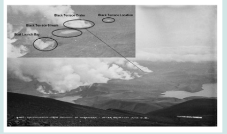
The Black Terrace spring drained to the lake, via a nameless stream which is here referenced as Black Terrace Stream. This led along a valley at an azimuth of 108º, entering the lake north of the Pink Terrace. The watercourse is now deep underground, beneath a forestry road on an alignment of ~110º from the Black Terrace to the Black Terrace Crater. The River Pilot lists Black Terrace Stream here as Drain 1019568 (Land Information New Zealand, 2022). The drain deserves to be renamed. From the survey cartography and georeferencing, as the crow flies the Black Terrace lies ~585 m from the stream exit on Hochstetter’s map (~500 m on Petermann’s map in (Figures 1 & 2)). The Black Terrace lies within the (Figure 4 & 12) search boxes. (Figure 9): Black Terrace, Black Terrace Crater, and Stream with Boat Launch Bay. A. Burton, 1886. (Inset, MA_I269460 Te Papa National Museum of New Zealand). (Figure 9) is an August 1886 photograph of the northwest section of the eruption crater. The inset shows (from right to left) the Black Terrace location marked by upwelling surface ponding. Two hundred meters away, the Black Terrace Crater is erupting. The post-eruption course of the Black Terrace Stream is marked by water flow and its exit 460 m away into what is now termed Boat Launch Bay. Note the steaming-fog plume from the main crater entry at Boat Launch Bay. This is one of seven eruption craters along the north shore (Nairn [30]). This one erupted beneath the Black Terrace Stream near its exit into the old lake Note: this photograph shows there were two eruptions through the bed of Black Terrace Stream: one creating Boat Launch Bay and a second creating Black Terrace Crater. The eruption sequence proceeded upstream under the Black Terrace Stream exit on 10 June, and under the Black Terrace Crater on 31 July 1886. There were no further eruptions along the course of Black Terrace Stream. This is negative evidence for the survival of Black Terrace in situ upstream from the Crater. (Figure 9) is attributed to Alfred Burton (1834-1914) but the photograph was probably taken by Charles Spencer (1854-1933). Ponding over the Black Terrace location is noted, with the Black Terrace Crater and surface water flowing between the locations into what became Boat Launch Bay.
While in 2017 this water-flow connection had not yet been made, its significance was raised at the October PAWTL2 session: From your Sunday talk, these may be … lateral flow from the bentonite-capped Te Tuhi’s Spring, running down till they hit the hotspot under the BTC [Black Terrace Crater] location? There was a 51-day hiatus between eruptions i.e., Rotomahana and BTC and where else could the subsoil water fuel have come from...? (pers. comm. R Bunn: P White [19]). Little rain had fallen in the interim. It is noteworthy that surface water was reported in this area in June and July, before the July 31 eruption (Leys [15]). This evidences water flow from Te Tuhi’s Spring, between the June 10 and July 31 eruptions.
Black Terrace photogrammetric optics
The original (Figure 9) print is uncropped. The aspect ratio of 1.31 indicates it was taken on a whole-plate camera with the view angle of a standard lens of 216 mm focal length (Dallmeyer [31]). Very rarely do Rotomahana prints qualify for photogrammetry of any kind (Bunn [5]). The camera position was found on Google Earth, by the photographer’s rule of thirds composition i.e., composing the features on a photograph with a grid, which divides the image into thirds. The camera coordinates were ~ 38.2349° S, 176.4905° E. In (Figure 10), the position on Google Earth is shown by the central blue ray (other rays are related survey bearings). The tripod was located below the crater rim, with the line of sight to the left of Tarawera Dome. Black Terrace Stream is centrally located for minimal lens distortion. There appears to be little or no lens shift. The actual Black Terrace Crater-Mt Tarawera object distance is 6,730 m vs photo- estimated at ~7,200 m, a 6.5% perspective error, partly from slight foreshortening. position below the Tarawera summit, with Tarawera Dome on the right. Other rays are survey bearings (Google Earth).
Applying photogrammetric optics with the similar triangle’s method (Ask [32]; Langford [33]); the key measures are:
a) Black Terrace-Black Terrace Crater (edges) ~200 m
b) Black Terrace Crater – main Crater ~460 m
c) Black Terrace Stream estimated length ~760 m.
I compared the same measures from Hochstetter’s 30 April map georeferencing at ~200 m, ~390 m, and ~700 m. There is reasonable agreement between the methods; sufficient to confirm a horizontal gap existed between Black Terrace and Black Terrace Crater locations. The Black Terrace Crater appears in the 1894 map in (Figure 11) (Smith [16]). The adjacent Black Terrace location appears, (though it may be an artifact on the 60 position). It is the right location and would supply water fuel to Black Terrace Crater and via Black Terrace Stream into the old and new lakes. The present outlet vents continuous bubbles as does the Crater. Also shown is the then-new Trig station on Te Kumete.
Surface artifacts
The PAWTL2 team in 2017 and later White searched for surface evidence of the Black Terrace and the nearby Crater: Proximity to the crater is indicated by boulders (up to 1.5m diameter) that overlie the Rotomahana mud near the site. Those boulders are mostly rhyolite but include several fragments of silica sinter (White [19]). Where White reports boulders and sinter, PAWTL2 members in 2017 recorded sinter, boulders and a rare fossil lying 100-200 m from Black Terrace and a similar distance from the Black Terrace Crater location. The 2017 PAWTL2 Project sample collection is held at Whakarewarewa, Rotorua and appears included (without acknowledgment) in White’s (Figure 2). Note that while surface rocks and sinter are found around the lake, most large blocks were carried in by surge flows rather than emplaced as ballistic.
ejecta (Nairn [30,34]). The PAWTL2 Project fossil is linked to Black Terrace Crater and Black Terrace Stream, for Scion™ analysis showed it is rare, geothermally fossilized wood: ‘I can confirm it was wood but is completely fossilized/mineralized… I am guessing this type of mineralization could occur in a geothermal environment … fossilized wood is very uncommon in NZ-I only know of one other incidence (a fossilized Kauri Forest in Southland) ...’ (pers. comm. L. Donaldson: R. Bunn [13]).
This fossil evidence the nearby location of Black Terrace Crater but not necessarily of the Black Terrace-for petrified wood was reported only around Black Terrace Crater in 1886: Numerous boulders and stones of all colour and descriptions lie scattered about in all directions. We picked up some fine specimens here, amongst which were lumps of petrified wood and charcoal.’ (New Zealand Herald). These site reports reveal that among the boulders, stones and petrified wood, there was no silica sinter seen in or around the crater. This surprised visitors and one described Black Terrace Crater as a misnomer. I have seen one lay mention of possible sinter near the Crater, but other reports remark on its absence. The sinter I and White found likely came from the Black or Pink Terrace or another non-terrace site and not Black Terrace Crater.
The PAWTL2 fossilized wood can be viewed at the System for Earth Sample Registration (SESAR).
Testing prior investigations
Joint New Zealand-American project, Keir, Hook and Lorrey et al.
The rediscovery of Black Terrace Crater enables the evaluation of earlier Pink and hite Terraces studies. Chief of these are the 2011-2014 findings by a joint New 657 Zealand-American project (de Ronde [1-3]). Measurement was undertaken of their reported distance from Pink Terrace-Black Terrace Crater at ~900 m (de Ronde [3]). This is a ~500 m error against the Hochstetter (340 m) and Petermann (464 m) maps. The New Zealand-American Pink Terrace-Black Terrace distance is ~1,150 m, an error of ~500 m against Hochstetter and Petermann cartography Warbrick A [35]. Over a small lake of 1,600 m in length, these are egregious errors. Other workers in 2018 related Black Terrace Crater to Pink Terrace, georeferencing with the Petermann map to posit ~900 m. Their paper has been criticized for methodological and dataset issues and a Pink Terrace-Black Terrace distance of ~1,140 m. The horizontal errors are as significant as the joint New Zealand-American project (Lorrey & Woolley [36, 37]). That year Keir, de Ronde and Hook also published Pink and White Terrace locations; each relying on preeruption photography (Keir [38] Hook [11]; de Ronde, [3]). Keir’s locations erred from Hochstetter’s survey coordinates by ~ 465 m (Pink Terrace) and ~ 438 m (White Terrace). Both Keir’s and de Ronde’s locations were criticized by Hook, despite his own errors of ~ 346 m and ~ 531 m (Hook [11]).
All these researchers followed Alpha Harding (1856-1945), who mistakenly placed old Lake Rotomahana inside the new Lake Rotomahana (Harding, 1887). The only researcher publishing a pink Terrace location near Hochstetter’s shoreline coordinates is Herbert Fitzgerald (Fitzgerald [39]). Fitzgerald and the author lived near Rotomahana, with the advantage of immersion in the colonial landscape. All other present-day researchers also err altimetrically, by relying on Keam’s guess i.e., that the pre-eruption Lake Rotomahana altitude was ≤292 MASL; rather than on the published, evidence-based altimetry of 303 MASL (Keam [17]; Bunn & Nolden [12]; Bunn [18]). Their trust is misplaced for White reports the base of Black. Terrace Crater lies at 305-310 MASL (White [19]). Were Keam’s guess correct; White’s Crater and Black Terrace elevation would lie in mid-air. This instances the priority the author attaches to evidence-based altimetry at Lake Rotomahana (Bunn [18]). The nineteenth-century vertical datum in the Rotomahana Basin was inaccurate, for the Bourdon pressure gauges used had significant errors (Bunn [18]). The new crater Lake Rotomahana surface is 35- 37 m higher than the old lake, making it impossible to reproduce proximal, pre-eruption photographic sightlines: hence the 689 importance of Hochstetter’s survey bearings.
White’s findings on black terrace crater
White et al accept the colonists’ assumption Black Terrace Crater erupted on/near the Black Terrace site, yet like the colonists produce no dark sinter evidence. They report: None of the sinter boulders found to date near this site are black; most are typical white siliceous sinters (White [19]). The burden of proof requires black or dark colored sinter, and none was found beside Black Terrace Crater. Otherwise, the findings are consistent with Hochstetter’s survey and help confirm the Black Terrace location.
Referencing (Figures 1) through 6:
a) White and our georeferencing agree Black Terrace Crater lies under the forest road. Along a 110º azimuth, the road overlies Black Terrace Stream. This lies 40-50 m below it in an alluvial valley, on a ~108º azimuth.
b) The diameter of the kidney-shaped Black Terrace Crater agrees with eyewitness accounts and is consistent with it being centered beneath the road.
c) The crater base lies at 305-310 MASL, consistent withit erupting midway along the Black Terrace Stream at this altitude.
d) White’s crater altitude is consistent with our lake altimetry of 303 MASL. It invalidates Keam’s guess ≤292 MASL (Keam [17]).
e) White’s findings support the author’s conclusion that the lakeshore overlaps the old lake shore here.
f) As with the PAWTL2 Project in 2017, the GPR unit failed to penetrate the Rotomahana mud, and the altimetry cannot be reconstructed i.e., from the pre-eruption surface to the present surface; 40-50 m across sloping ground. White’s seismic data, however, enables the altimetry.
g) Recognizing Black Terrace Stream lies beneath the road, suggests White’s upstream GPR and seismic horizons may be post-eruption discordant stream beds 716 connecting Black Terrace with the Crater.
h) White overlooks Hochstetter reporting the Black Terrace lay in a Side Valley. The cartography shows it lay in a Side Valley with Black Terrace Stream entering the 719 lakes between Whakataratara and Waiti. White’s GPR and seismic imagery show alluvial stratigraphy upstream and probably downstream from Black Terrace Crater. These indicate the Crater lies along Black Terrace Stream and not in the Side Valley where cartography and eyewitnesses place the Black Terrace. The stratigraphy of the Black Terrace site would not resemble that of the Black Terrace Crater in White (White [19]).
i) Black Terrace-Te Kumete cartography verifies the Terrace lies west of the Crater.
Conclusion
In Table 1, the final Cartesian coordinates for the Black Terrace spring are shown. Coordinates for the Pink and White Terrace spring centers are also shown. The Terrace apron footprints are summarized. These derive from the nine triangulation 731 methods reported in this paper (Table 1). Terrace spring and apron locations from triangulation studies with Hochstetter’s survey (Bunn [40]). The midpoint spring coordinates in (Table 1) are from an analysis of georeferenced Hochstetter and Petermann maps, and terrestrial survey-bearing resection; where the Black Terrace spring lies within the 2019 search box on each map, as in (Figure 12) (Bunn [37, 5]). Underlining its significance, Black Terrace lies outside the border on Petermann’s map in (Figure 12). (Figure 12): Black Terrace Spring georeferenced on Google Earth via Hochstetter’s stations as control points; from his 1859 map (middle layer) and Petermann’s 1864 map (top layer). Both locations lie within our 2019 Black Terrace search box, shown in green (left). Neither overlay shows Black Terrace inside the right Black Terrace Crater search field. Note Black Terrace Stream passing through the rightside search box.
Figure 12: Black Terrace Spring georeferenced on Google Earth via Hochstetter’s stations as control points; from his 1859 map (middle layer) and Petermann’s 1864 map (top layer).
Discussion
The empirical evidence on the location of Black Terrace Crater is timely, for current research enables Hochstetter’s 1859 survey triangulation to be followed across the North Island to Lake Rotomahana (Bunn & Nolden [14]). Black Terrace Crater lies within the search field established in 2017 (Bunn [13]). The Black Terrace location lies nearby. The Black Terrace Crater was triangulated with the Black, Pink and White Terraces via spatial and topographic analysis, forensic cartography, georeferencing, survey resection, photointerpretation, photogrammetric optics, trigonometry, and surficial artifacts, with Google Earth. While Black Terrace Crater has not been excavated, its Cartesian coordinates confirm recent subsurface imaging. The Crater allows empirical testing of previous studies, which estimated the Black Terrace Crater-Pink Terrace distance at ~900 m (de Ronde [3]; Lorrey [36]). Both the de Ronde et al and Lorrey et al studies have a horizontal hamartia. Keir and Hook have similar errors, despite Hook claiming to have resolved what he termed the battle of the maps (Hook [11]). Following Harding’s mistake, all these workers mistakenly placed the Pink and White Terraces over the new crater lake. Further, all these workers applied incorrect altimetry (Bunn [18]). A Black Terrace Crater-Pink Terrace distance of ~340 m debars Black Terrace Crater being coterminous with Black Terrace, as some colonists and White suggest (Bunn AR [41]).
The devastation meant no colonist could say where proximal landmarks lay. The only published maps i.e., Hochstetter and Petermann’s agree the Black and Pink Terrace springs were ~700 m apart. The surveyed location of Black Terrace lies close to Black Terrace Crater, along the same forest road: enabling access for excavation. The Crater provides a new survey reference for the terraces after Rangipakaru Hill was confirmed as the first surviving proximal landmark (Bunn [5]). The Hochstetter dataset and Black Terrace Crater findings together enable sub-surface imaging, drilling, and excavation at Lake Rotomahana; to verify the survival and enable possible recovery of the fabled terraces to the public gaze, with the concomitant national tourism boom (Bunn [18, 6]).
Acknowledgment
I acknowledge Dr Sascha Nolden, without whom this research at the Rotomahana Basin would not have been possible. A preprint of this paper was submitted to EarthArXiv.
Note: The literature review in the introduction formed part of a tranche of Black Terrace Crater research supplied on request as an invited co-author, to Dr Phil White for a 2020 conference presentation on Black Terrace Crater (White [19]). This contribution was unacknowledged in his paper (13 pers. comms. ARB:PW 25/6/2020─30/7/2020).
Funding
This research was self-funded by the author, in the public interest.
Conflict of Interest
The author has no conflicts of interest to declare and there is no financial interest to report. I certify that the submission is original work.
References
- De Ronde CEJ (2011) Scientists find part of Pink and White Terraces under Lake Rotomahana.
- De Ronde CEJ, Fornari DJ, Ferrini VL, Walker SL, Davy BW, and LeBlanc C, et. all (2016) The Pink and White Terraces of Lake Rotomahana: What was their Fate after the 1886 Tarawera Eruption? Journal of Volcanology and Geothermal Research 314: 126-141.
- De Ronde CEJ, Tontini FC, Keam RF (2018) Where are the Pink and White Terraces of Lake Rotomahana? Journal of the Royal Society of New Zealand 49(1): 36-59.
- Bunn A Rex (2019a) Photographic embellishment and fakery at the Pink and White Terraces. New Zealand Legacy 31(1): 5-10.
- Bunn AR (2020b) Reconciling New and Old Surveys of the Pink and White Terraces 102: 29-36.
- Bunn AR (2021) Ngāti Rangitihi Claims Settlement Bill.
- Johnston M, Nolden S (2011) Travels of Hochstetter and Haast in New Zealand, 1858-1860. Nikau Press Nelson.
- Hochstetter F, Petermann A (1864) Geological and Topographical Atlas of New Zealand. De Lattre Auckland.
- Mundy DL (1875) Rotomahana, and The Boiling Springs of New Zealand. Nature.
- McFadgen B (1999) Archaeological Site Recording in New Zealand, New Zealand Archaeological Association page: 1-150.
- Hook G, Carey SP (2018) Relocating the Pink and White Terraces of Lake Rotomahana, New Zealand: resolving the ‘battle of the maps. Tuhinga 30: 178-208.
- Bunn AR, Nolden S (2018) Forensic cartography with Hochstetter’s 1859 Pink and White Terraces survey: Te Otukapuarangi and Te Tarata. Journal of the Royal Society of New Zealand 48: 39-56.
- Bunn AR (2017) Rediscovering Te Tuhi’s Spring and Black Terrace Crater, The Forgotten Rotomahana Spring and Crater.
- Hochstetter F (1867) New Zealand: its physical geography, geology, and natural history with special reference to the results of Government expeditions in the Provinces of Auckland and Nelson. Cotta Stuttgart.
- Leys TW (1887) A Weird Region: New Zealand Lakes, Terraces, Geysers, and Volcanoes, with an Account of the Eruption of Tarawera. Auckland, NZ.
- Smith SP (1887) The Eruption of Tarawera: a report to the surveyor general. New Zealand Surveyor-General.
- Keam RF, Lloyd EF (2016) GOSA Transactions: The Journal of the Geyser Observation and Study Association pp. 13-39.
- Bunn AR (2014) Raising the Tattooed Rock- A Tourism Proposal of National Significance. Plenary Meetings of the TTA and PAWTL Project At: Rotorua, New Zealand.
- White P, Lorrey A, Woolley JM, Vidanovich P (2020) Black Terrace, Rotomahana.
- Nolden S, Nolden SB (2013) Hochstetter Collection Basel.
- Bunn AR (2023a) Resolving the 1886 White Terraces riddle in the Taupō Volcanic Zone. Frontiers in Earth Scienc 11-2023.
- Hardwicke Knight (1971) Photography in New Zealand: A social and technical history.
- Bunn A Rex (2019a) Photographic embellishment and fakery at the Pink and White Terraces. New Zealand Legacy 31(1): 5-10.
- Keam RF (2015) The Tarawera eruption, Lake Rotomahana, and the origin of the Pink and White Terraces. Journal of Volcanology and Geothermal Research 314: 10-38.
- Bunn AR (2019b) Hochstetter’s Survey of the Pink and White Terraces: The Final Iteration 99: 30-35.
- Warbrick A (1934) Adventures in Geyserland : life in New Zealand's thermal regions, including the story of the Tarawera eruption and the destruction of the famous terraces of Rotomahana / told by Alfred Warbrick (Patiti) ; with a preface by James Cowan.
- Bunn AR (2022) The first evidence-based altimetry for locating the lost Eighth 839 Wonder of the World: The Pink, Black and White Terraces. Academia Letters.
- Bunn AR (2016) Quest for the Pink and White Terraces: The Expedition to Recover New Zealand's Eighth Wonder of the World.
- Bunn A Rex (2023c) The Kaiwaka Channel in the Taupō Volcanic Zone-Passive Seismic Studies and the Smith-Keam and Hochstetter Paradigms.
- Nairn IA (1979) Rotomahana-Waimangu eruption, 1886: base surge and basalt magma. New Zealand Journal of Geology and Geophysics 22(3): 363-378.
- Dallmeyer JH (1874) On the Choice and use of Photographic Lenses. Anthony New York.
- Reynold E. Ask (1943) Elements of Photogrammetric Optic pp. 1-31.
- Langford M, Anna Fox, Richard Sawdon Smith (2010) Langford’s Basic Photography, Focal Press, Oxford, USA.
- Nairn IA (2002) Geology of the Okataina Volcanic Centre.
- Warbrick A (1902) The Lost Terraces. New Zealand Herald.
- Lorrey AM, Woolley JM, Rex Bunn (2018b) Locating Relic Sinter Terrace Sites at Lake Rotomahana, New Zealand with Ferdinand von Hochstetter’s Legacy Cartography, Historic Maps and LIDAR. Frontiers in Earth Science.
- Bunn AR (2020a) Commentary: Locating Relict Sinter Terrace Sites at Lake Rotomahana, New Zealand, With Ferdinand von Hochstetter’s Legacy Cartography, Historic Maps, and LIDAR. Frontiers in Earth Science 8: 68.
- Keir W (2018) The location of the Pink and White Terraces of Lake Rotomahana, New Zealand. Journal of the Royal Society of New Zealand 49(1): 1-20.
- Fitzgerald HF (2014) The pink and white terraces revisited: an account of ten years of research on Mount Tarawera Lake Tarawera and Lake Rotomahana : answers to how the pink and white terraces disappeared and the long lasting mysteries surrounding the volcanic eruption of 10th. June 1886/Author: Herby Fitzgerald.
- Bunn A Rex (2023b) Coanda and Venturi Effects at the Eighth Wonder of the World the White Terrace-Resolving the East Wind eruptions at the White Terraces. HSOA Journal of Environmental Science Current Research 6: 44.
- Bunn AR, Davies N, Stewart D (2018) Dr Hochstetter’s Lost Survey. 94: 5-13.

Top Editors
-

Mark E Smith
Bio chemistry
University of Texas Medical Branch, USA -

Lawrence A Presley
Department of Criminal Justice
Liberty University, USA -

Thomas W Miller
Department of Psychiatry
University of Kentucky, USA -

Gjumrakch Aliev
Department of Medicine
Gally International Biomedical Research & Consulting LLC, USA -

Christopher Bryant
Department of Urbanisation and Agricultural
Montreal university, USA -

Robert William Frare
Oral & Maxillofacial Pathology
New York University, USA -

Rudolph Modesto Navari
Gastroenterology and Hepatology
University of Alabama, UK -

Andrew Hague
Department of Medicine
Universities of Bradford, UK -

George Gregory Buttigieg
Maltese College of Obstetrics and Gynaecology, Europe -

Chen-Hsiung Yeh
Oncology
Circulogene Theranostics, England -
.png)
Emilio Bucio-Carrillo
Radiation Chemistry
National University of Mexico, USA -
.jpg)
Casey J Grenier
Analytical Chemistry
Wentworth Institute of Technology, USA -
Hany Atalah
Minimally Invasive Surgery
Mercer University school of Medicine, USA -

Abu-Hussein Muhamad
Pediatric Dentistry
University of Athens , Greece

The annual scholar awards from Lupine Publishers honor a selected number Read More...


