Lupine Publishers Group
Lupine Publishers
Menu
ISSN: 2637-4668
Research article(ISSN: 2637-4668) 
Asphalt Roadholding in A Tropical Climate: The Example of Guinea Volume 4 - Issue 2
Diaka Sidibé1*, André Lecomte2, Malick Somparé3 and Henri Loua3
- 1Higher Institute of Mines and Geology, Boké, Guinea
- 2Institut Jean Lamour, UMR 7198, University of Lorraine, Nancy, France
- 3Ministry of Public Works of Guinea, Conakry, Guinea
Received:July 15, 2021 Published: July 27, 2021
Corresponding author:Diaka Sidibé, Higher Institute of Mines and Geology, Boké, Guinea
DOI: 10.32474/TCEIA.2021.04.000186
Abstract
This study uses the periodic surveys of the degradation of Guinea’s paved roads from the country’s Road Database. Processing the data from five representative sections shows that these structures suffer recurrent degradation, often located at the same places on the roads. These degradations are mainly manifested by deformations of the pavement, marked by collapses and pronounced ruts. Simulations with the Alize software show that the causes of these disorders are mainly related to problems of the evolutionary bearing capacity of the lateritic support soil between dry and wet periods. This parameter is apparently not yet well integrated into current methods of pavement design in tropical climates. This work can therefore be used to initiate new studies of the mechanical and dimensional behaviour of lateritic materials according to climatic cycles and of the improvements that can be made to them by treatments with hydraulic binders in particular.
Keywords:laterites; pavements; diagnosis; degradation; dimensioning
Introduction
General context
Roads in tropical environments are subject to severe constraints which are a source of recurrent degradation. Traffic intensity and rolling loads are the main causes, especially if the pavement structure is undersized. Water then alters the stability of the various layers forming the pavement Fwa,[1]. However, variations in the bearing capacity of the subgrade - usually lateritic in natureinflicted by seasonal water contrasts clearly also play an important role Jayakumar and Soon, [2]; Muthuramalingam and Soon, [3].
The diagnosis of a pavement starts with the observation of its surface condition. This makes it possible to identify surface deterioration in order to define a maintenance programme. However, it must also make it possible to identify the origin of the disorders in as much detail as possible so that more permanent reinforcements can be undertaken or even to improve the dedicated sizing method. Regular and codified diagnosis of roads in tropical climates is still a recent practice, at least in most African countries. The few published works on the subject concern methods to diagnose the condition of the different layers composing the structure, for example by measuring the deflection of the surface under a standard wheel load [Smith & Jones, 1980], or to evaluate the quality of the supporting soils, for example using a Falling Weight Deflectometer (FWD) Razli et al., [4]. More generally, the literature focuses on the characterization of lateritic soils and their particularities Medina[5]; Ramana, [6]; Akpan and Edet, [7]; Camapum de Carvalhoa et al. [8] or their evolution under repeated solicitations Guimarães et al. [9]. Work also concerns the use of laterites as granular materials constituting pavement layers Medina, [10]; Mahalinga- Iyer and Williams [11]; Caro et al., [12], or the design methods of laterite pavements Mengue [13]. The objective of the present work is to find a response to this second objective. It is based on the degradation surveys of paved roads in Guinea carried out between 2009 and 2018 as part of the technical assistance mission of the Egis International and Louis Berger International offices at the Guinean Ministry of Public Works Somparé et al., [14]. These surveys were not subject to heavy in-situ investigations (lift, deflection, adhesion, longitudinal and transverse uniformity, etc.) and only surface observations were made and processed using the VIZIROAD system Autret and Brousse, [15]. However, the raw data from the VIZIROAD database constitute an original source of information on the condition and performance of paved roads in tropical environments. Some of these data have been included here and amended if necessary by the personal observations of the investigators who are the co-authors of this article.
It should be noted that VIZIROAD attributes a quality mark per pavement section based on the degradations described in the French “Catalogue of pavement degradations” published in 1972 by SETRA and LCPC SETRA/LCPC, [16] and repeated in other subsequent works LCPC, [17], for example]. The causes that led to the quality mark were thus identified, categorized and prioritized. This assessment then provides a set of original indications on the performance of pavements in tropical environments. This information will be used to define characteristic sites where samples will be taken in order to undertake a rational scientific study on the evolution of the bearing capacity of lateritic soils according to tropical climatic cycles, with or without appropriate treatment. The article begins with a brief description of the Guinean context and its road network. It then recalls the typical examples of degradation described in the reference guide for all intents and purposes. Degradations found on representative sections of Guinean paved roads are then analyzed and dealt with in categories. The main causes of recurrent disorders affecting these structures were thus identified. This work then provides scientific data that can later be used as a basis for recommendations for a better reinforcement of pavements in tropical climates or even for enhanced design parameters thereof.
The Guinean context
Geography, climate, geology and geotechnics
Guinea is a country in West Africa bordering the Atlantic Ocean. It is located between Senegal and Ivory Coast and also shares borders with Mali, Guinea-Bissau, Liberia and Sierra Leone. Its surface area is 245,857 km2. It has four distinct natural regions: in the west, the coastal zone or Lower Guinea; in the centre, mountainous Middle Guinea; in the north-east, Upper Guinea (savannah); in the south-east, Forest Guinea. Its tropical climate is characterized by a rainy season (April to November) in which trade winds (Alizés) coming from the ocean dominate and rainfall reaches 1,200mm (Upper Guinea) to 4,200mm (Lower Guinea) and a dry season (December to May) when the Harmattan blows from the Sahara. The average annual temperature is between 22 and 24°C with extremes between March- April (39°C in Lower Guinea) and December-January (4°C in Middle Guinea).
The geology of Guinea is composed of a crystalline basement of Precambrian age which outcrops mainly in Upper Guinea and Forest Guinea. It is made up of eruptive and metamorphic rocks which contain significant mineral wealth. In Middle and Lower Guinea, this basement is very often covered by sedimentary sandstone soils dating from the Devonian. There are also recent alluvial deposits located along the coast and on the routes of the rivers running through the country (Niger, Senegal, Gambia, Tinkisso, etc.). Under the influence of the hot and humid tropical climate, all these rocks have undergone a strong transformation into laterites which is characterized by high concentrations of alumina and iron oxide over a thickness of several metres to tens of metres, to the detriment of the leached silica Autret, [18]. In the upper part of laterites, alteration is often pushed to the clay stage Mamedov et al., [19]. In the eastern of Lower Guinea, laterites are more or less indurated and are in the form of a thick cuirass. Laterites thus constitute most of the road base soils in the country and are also a local mineral resource that can be used for the construction of road bodies (lateritic gravel). From a geotechnical point of view, Guinean laterites present a variety of facies Lacroix, [20], Autret, [21], Mamedov et al., [22]. They are often described Ndiaye, [23]. as sandy to gravelly soils with a fine fraction (< 80m) and a coarse fraction (2 to 20-40mm), each forming respectively 10-35% and 30-80% of the material. There are not many intermediate sizes (80μm- 2mm) which makes it difficult to carry out and interpret certain characterization tests such as the Atterberg limits practiced on the 0/400μm fraction Lyon Associates, [24]. The plasticity index associated with this test is generally between 10 and 35 Bagarre, [25]. The methylene blue value is generally found to be higher than 1.5g/100g and provides additional information on the clay content of these soils Ndiaye, [23]]. Finally, the coarse fraction of laterites presents variable hardness and is difficult to characterize depending on the chemical composition of the parent rock Ndiaye, [23].
Lateritic soils can be classified in different systems, such as HRB (Highway Research Board) or USCS (Unified Soil Classification System). According to the French GTR (Guide des Terrassements Routiers) classification [NF P 11 300, [26], these materials are generally in class B6 (largest grain size < 50mm; plasticity index IP > 10; fillers content between 12 and 35%). This document therefore specifies that their use as backfill or even as a form layer generally poses problems due to their rapid change in bearing capacity with the evolution of their hydrous state. If they are very wet or very dry they cannot be used. For intermediate water states, meteorological conditions lead to adapted implementation methods (extraction, aeration, treatment, humidification, compaction, etc.). For use in subgrade or even foundation layers, the GTR recommends their systematic treatment with lime and/or hydraulic binders. The application of these water-sensitive materials therefore requires special precautions. In wet periods, their bearing capacity is almost nil whereas in dry periods their bearing capacity is very good. The quality of a road built in (or even with) these laterites then depends directly on the period of its construction and its location in the project (excavation, embankment, etc.).
Road network, dimensioning, materials
The Guinean road network is currently 45,300 km long. It is made up of national (7576 km), prefectural (15,879 km), community (19,846 km) and urban (about 2000 km) roads. In 2018, only 2742 km of national roads (NR) were paved (they are the subject of this study), the rest of the network (42,560 km) were dirt roads. The paved network has grown year by year. It was 1124 km in 1984, 1253 km in 2010 and 2346 km in 2016. It is expected to reach 3200 km in 2020. The pavements constituting the paved roads in Guinea are mainly flexible pavements usually consisting of an asphalt wearing course (5 to 6 cm thick) over a base layer of untreated crushed materials (20 cms thick) and a foundation layer in mechanically stabilized natural lateritic gravel or NLG (25 to 30 cms thick).
There are also semi-rigid or mixed pavements where the base course and sometimes the foundation course is gravel treated with hydraulic binders. It is also possible for there to be an asphalt binder course interposed between the base course and the wearing course. These pavements are generally based on a subgrade course of “lateritic gravel” material but not always. Finally, there are some rigid pavements (urban roads in Conakry Ville) which consist of concrete slabs on a foundation layer of “lateritic gravel”. In addition, for several years now, road counting campaigns have been carried out on some NR, whether paved or not and axle scales have been installed on some axes. Since January 2018, the design of Guinean pavements has been based on the “General Guidelines for Standards of Design, Construction and Maintenance of Roads and Tracks in the Republic of Guinea” Guinea Guidelines. Previously, they were designed according to the recommendations of the “Guide de Denouncement des Chaussées des Pays Tropicaux” established by the Centre Experimental du Bâtiment et des Travaux Publics (CEBTP) CEBTP, [27]. According to this guide and the usual principles, the dimensioning of the structure is determined on the basis of the bearing capacity of the supporting soil (subgrade), the likely traffic and the technique concerned. Five classes of soil bearing capacity are defined in this guide, based on the CBR (Californian Bearing Ratio) NF P 94-078, [28]] and conventionally determined on specimens compacted to 95% of the Modified Optimum Proctor (MOP) after 4 days of soaking. The traffic class (5 classes) is deduced from the average number of vehicles circulating per day or from the cumulative number of heavy goods vehicles over the service life of the structure (15 years in this case). This guide also defines criteria for the selection of materials for the different layers. For the base and foundation layers, the corresponding specifications are based on a granularity spindle, the plasticity index of the fine fraction [NF P 94-051, [29] and the optimum Proctor density NF P 94- 093, [30]. Other works, such as those of Rodrigues et al., [31], cited by Ndiaye, [31], propose a more refined classification of lateritic soils by distinguishing fifteen categories for which one or more fields of use in road techniques are recommended. The dichotomy is based on granularity (fine, sandy or gravelly laterites) and, depending on the category, on the methylene blue test NF EN 933-9+A1, [32], the shrinkage limit of the fine fraction NF XP P 94-060-1, [33], the friability of the sands [NF P 18-576, [34], the fragment ability NF P 94-066, [35], the degradability of the concretions NF P 94-067, [36] and the CBR bearing capacity of the material. On the basis of conventional specifications for low-traffic roads, the authors then show that:
a. all lateritic soils can be used a priori as a subgrade, without treatment or with lime treatment for the finest soils;
b. as a foundation layer for gravelly and sandy lateritic soils, with or without treatment depending on their clay content;
c. as a base layer for gravelly lateritic soils of the best quality.
In any case, in Guinea, gravelly lateritic soils are widely used in road techniques. For example, in Forest Guinea, a publication states that lateritic materials were used as a foundation layer during the reconstruction of a section of NR No 2 [Egis International, [37]. The base course was made of crushed granitic materials (crushed gravel) and the wearing course of asphalt concrete.
Methodology
Degradation of paved roads
Baseline. A summary of relevant bibliographical references
For many years, catalogues and guides have been used to identify the deterioration of paved roads, particularly in temperate climates. In French documents which are taken as a reference here, the “Pavement Surface Degradation Catalogue, 1998 version” (Complement to Test Method No. 38-2: Survey of pavement surface distresses) [LCPC, [17]] is of particularly significance. It seems appropriate to recall briefly the main types of pavement damage described in this document, together with their origins. These are the following:
Deformations, including in particular:
a. Ruts induced by the repeated passage of heavy vehicles. They may result from a lack of bearing capacity of the soil, the use of poor-quality pavement materials (large radius ruts) or poor stabilization of the asphalt revetment (small radius ruts);
b. Shoreline subsidence resulting in a trough and bulges along the banks. They reflect pavement fatigue (thickness, quality of materials) and are worsened by the action of water trapped in the basin;
c. Uneven surfaces materialized by a regular corrugation perpendicular to the axis of the road; Cracks or break lines appearing on the pavement surface. They can be:
a. Transverse to the pavement in which case they are generally the result of thermal shrinkage and an underlying layer setting made up of materials treated with hydraulic binders;
b. Longitudinal to the pavement, insulated, in slabs or with varying contours. They reflect pavement fatigue following failure of the supporting soil (settlement, desiccation), an increase in traffic, a construction defect (widening, defective asphalt joints, etc.) or soil shrinkage after a long drought;
c. Of the crazing type, with cracks forming a more or less dense mesh. They are generally due to fatigue of the wearing course or even of the entire structure (undersized in relation to the traffic and the low bearing capacity of the soil);
Pull-outs, most often corresponding to an advanced stage of previous degradations, with the departure of materials. They are related to poor pavement quality or loss of waterproofing of the wearing course. Examples include:
a. Potholes or circular cavities 5 to 10 cm deep;
b. “Pelades” or tearing off of the wearing course by slabs;
c. Plumes where gravel is pulled off;
d. Stripping where the putty around the aggregates is destroyed
e. Etc.
The movement of materials being:
a. In the surface layer: the binder bleeding in hot periods, the gravel sinking, the fillers rising;
b. Deeper: mud and water rising to the surface through cracks and joints when heavy vehicles pass.
This catalogue also specifies the pavement deterioration processes according to the type of structure (structural deterioration). The processes that may concern Guinean pavements are briefly listed below (excluding the marginal case of rigid pavements made of concrete slabs):
a. Flexible pavements: for this type of pavement, the repeated action of loads and/or the hydric evolution of the supporting soil lead(s) to a plastic deformation of the granular structure marked by permanent surface deformations (large radius ruts, subsidence of banks). Longitudinal cracking is also present and evolves towards fine-meshed crazing. These disorders help cause water infiltration which then amplifies the loss of bearing capacity of the supporting soil in rainy periods and aggravates the permanent deformations, with the appearance of pull-outs, then potholes, etc.;
b. Semi-rigid pavements made of materials treated with hydraulic binders: these are characterized by transverse shrinkage cracks spaced about ten metres apart or even by longitudinal cracks linked to traffic or movements of their support (settlement, water shrinkage, etc.). If these cracks are not sealed, meteoric water will penetrate the structure and cause the wearing course to loosen and the subgrade to deteriorate. These cracks can also lead to the formation of independent slabs and then to the modification of the load transfer system. In addition to the cracks, surface damage may occur such as fines, cracks and potholes rising. Finally, the specific feature of each type of coating are also described (surface damage):
• For asphalt concrete wearing courses, channelled heavy traffic, temperature and ageing of the bitumen generally lead to the formation of small radius ruts and beads while for flexible pavements these lead to cracking and crazing of the asphalt or even the removal of gravel and mastic;
• For surface dressings, traffic and climate-related deterioration generally involves the removal of gravel and/or the sweating of the binder.
In order to be efficient, the damage recording must comply with a rigorous procedure in terms of its implementation, operation and interpretation LCP 38-2, [38]. To achieve this, methodologies and numerical tools have been developed to assist in the diagnosis of a pavement and scoring systems implemented to assess its quality.
In France, for more than 25 years, an “IQRN” (Image Qualité du Réseau National) rating has periodically been awarded to pavements on the national road network. The IQRN rating system [IQRN, 2000] initially used an “overall score Ng”, a synthesis of a “patrimonial score Np” expressing the structural potential of the pavement and a “surface score Ns” reflecting the condition of the pavement. These two ratings which make up the “overall score” are expressed in the same 0 to 20 reference system and are attributed according to the cost of the work required to restore a section of pavement to its reference condition. A score of 20 corresponds to an excellent condition, while a score of 0 corresponds to a very degraded pavement requiring maximum work. Since 2014 IQRN, [39], the scoring system has included two indicators of the financial valuation of the pavement condition (the patrimonial score Np and the overall score Ng) and an indicator of the level of use offered by pavement Iu (grip, conservation of the integrity of the surface layer).
Nevertheless, the pavement deterioration survey should always comply with the procedure defined in the “Pavement Surface Degradation Catalogue” LCP 38-2, [40]. Today, it is carried out with the assistance of specific monitoring equipment and software such as AMAC/MAPM (Multifunction Apparatus for Pavement Monitoring): simultaneous measurements of evenness, macrotexture, cross-section and the recording of damage Nguyen et al., [41]. The survey is generally accompanied by skid resistance and roughness measurements also carried out using dedicated equipment. The periodic IQRN scores are then used as a basis for the maintenance policy of the national road network. Finally, since the end of 2016, the National Project DVDC (Road Service Life) [www.dvdc.fr] has been working on new diagnostic methods and modelling tools for estimating the evolution and residual service life of road infrastructures.
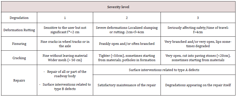
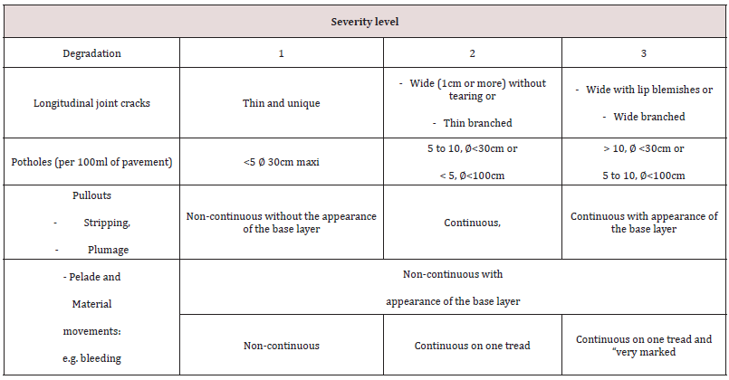
For most West African countries and for flexible pavements, the “VIZIROAD” computerized evaluation, qualification and prioritization system is currently in use Autret and Brousse, [42]. This approach is carried out using a tablet proposing predefined typologies and consists of identifying the various degradations in situ and qualifying them in three levels (1 to 3) according to their severity level and extent, distinguishing between type A degradation which affects the pavement structure (Table I) and type B degradation which concerns the surface (Table 2).
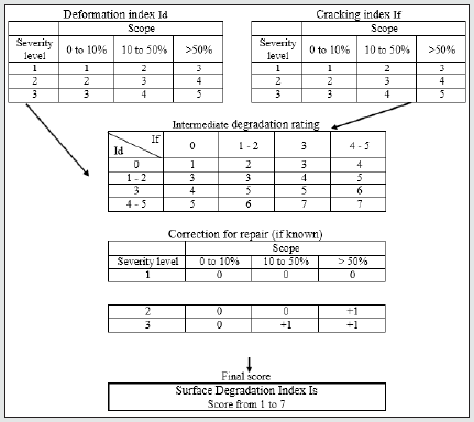
For type A damage, visual inspection is sufficient to attribute a surface damage index (Is) of between 1 and 7 which gives an overall assessment of the structure over a given length. This index results from the intersection of two previously calculated indices: the cracking index If and the deformation index Id, both deduced from the severity level and extent of the corresponding disorders. The resulting score may be further weighted according to the state of any previous repairs that may have been made. Figure 1 summarizes this approach.
Finally, an additional qualification in terms of quality can be applied, taking deflection into account (lift test for example NF P 94-117-1, [43]. The raw data from the “VIZIROAD” database used to attribute cracking, deformation and surface degradation indices is therefore a valuable source of information for statistical identification of the causes of the disorders.
Surveys Carried Out in Guinea
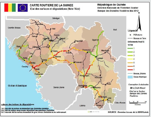
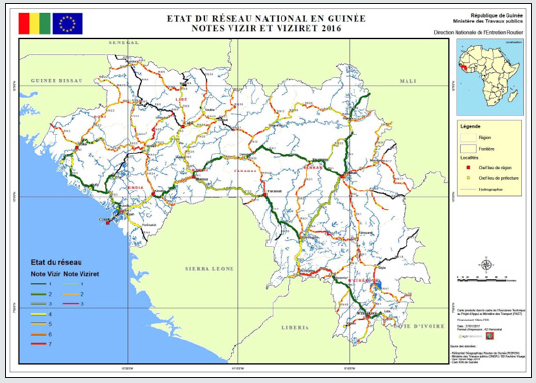
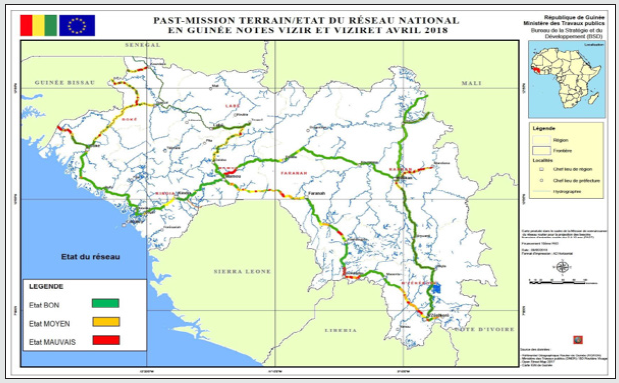
Since 2009, several “VIZIROAD” surveys on all or part of the Guinean road network have been carried out by the Guinean Ministry of Public Works, with technical assistance from Egis International and Louis Berger International and financial support from the European Development Fund (EDF) Somparé et al., [14]. They resulted in the publication of three maps dated 2012, 2016 and 2018 describing the state of surfaces and road network degradation (Figures 2, 3 and 4). The maps show that the condition of some paved sections is changing rapidly, presenting:
a. Either an improvement of their previous condition, following maintenance works, as for example between 2012 and 2016 for the Mamou - Kouroussa section of the RN No 1;
b. or a deterioration of their previous condition, as for example between 2016 and 2018 for the Mamou-Faranah section of RN No 2.
A detailed comparison of these maps then illustrates the rapid evolution of a road network in a tropical climate and the difficulty of maintaining it in a satisfactory state.
In addition, as previously reported, periodic counts have recently been introduced in some RNs, notably on the sections linking Conakry to Mamou (RN No. 1) and Conakry to Boké (RN No. 3). The average number of vehicles circulating daily on these roads (in both directions) was found to be around 6500 units. For single trucks (2- or 3-axle trucks, semi-trailers, buses, etc.) - often overloaded - the figure is 1500 to 4000 units. According to the “Guide de Dimensionnement des Chaussées des Pays Tropicaux” CEBTP, [27], the corresponding traffic class is therefore T4 or even T5, i.e. very high traffic classes. For such traffic (e.g. T4), considering a soil bearing capacity class of “S3” (10 < CBR < 15) and a flexible pavement structure typical of paved roads in Guinea (see § 2.2), consisting of an asphalt concrete wearing course, a base layer of crushed material (granite) and a foundation layer of natural lateritic gravel materials, the guide recommends respective thicknesses of 7, 25 and 25 cm,
i.e. approximately the thicknesses usually laid (see § 2.2).
Results and Discussion
A reminder of the approach used
In the proposed approach, we chose to use the raw “VIZIROAD” data, i.e. the severity level scores 1, 2 or 3 (0 if no disorder) attributed to the different degradations (i.e. deformations, cracking, crazing), rather than the surface index Is, the intermediate cracking index If or the deformation index Id. The idea is to statistically quantify the importance of each type of degradation to identify their main causes (bearing capacity of the ground, pavement structure, quality of the surface layer, etc.), with regard to the pathologies mentioned above (see § 3).
Raw data from the road database (RDB)
All “VIZIROAD” information collected in the field is included in a “Road Database or RDB” where it is identified by:
a. the NR and the section where it is located (a section generally separates two cities);
b. the position and the length (extent) of the severity level (abscissa of beginning and end, longitude and latitude of beginning and end);
c. the amplitude of severity level (0, 1, 2 or 3);
d. the date of the information.
Thus, deformations, cracking and crazing are characterized over the entire length of each section travelled.
The Guinea RDB currently contains data on most of the country’s coated NRs (about ten NRs). For the purposes of this work, only information relating to four NRs covering the main regions of Guinea was considered. These are the RNs:
i. No. 1 linking the capital Conakry to Lola in the south-east, i.e. more than 1000 km divided into 10 sections covering Lower Guinea, Middle Guinea, Upper Guinea and Forest Guinea;
ii. No 2 linking Mamou to N’Zérékoré in the south-east, i.e. more than 680 km divided into 6 sections covering Middle Guinea, Upper Guinea and Forest Guinea;
iii. No 3 linking Conakry to Boké in the west, i.e. more than 250 km divided into 4 sections covering Lower Guinea alone;
iv. No. 5 linking Mamou to the Senegalese border in the northwest, i.e. more than 420 km divided into 6 sections covering Middle Guinea.
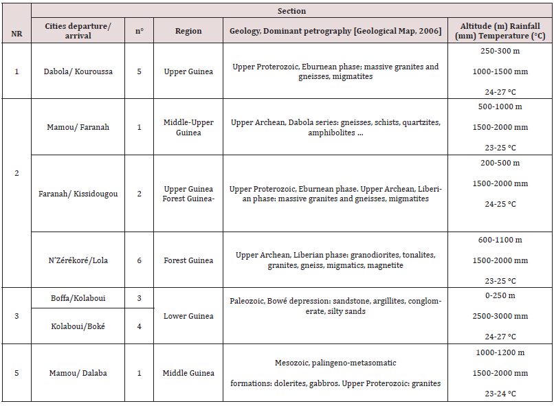
Table 3 lists the missions (degradation surveys) carried out on these NR between 2009 and 2018 and lists the regions concerned for each section. It also shows that a survey campaign does not concern all the NR or all the sections of the same NR (the sections not covered during a campaign are generally covered during the following campaign). The 2016 and 2018 maps (Figure 3 and Figure 4) were therefore drawn up including results from certain previous surveys for sections which were not studied for these maps from these two years because of the personnel and time that these surveys require. Despite this, each NR covers sections that have been checked at least three times during the period in question. It is also important to take into account the geological nature of the bedrock underlying the laterites as identified on the geological map of Guinea [Geological Map, 2006].
Finally, it is desirable that the different natural regions of the country be represented. Cross- referencing these parameters, six sections were selected to form the basis of the statistical study presented below. These sections are described in Table 4 which includes their geographical location (NR, starting and ending cities) and briefly describes the geological context of the subsoil and the average environmental conditions (rainfall, temperature, altitude). In this approach, the campaigns of November 2009 and February 2010 and those of November 2011 and February 2012 have been grouped together.
Finally, to complete the analysis, it is also important to remember that Guinean roads benefit from different levels of maintenance, namely:
1. “routine maintenance” where localized damage is regularly repaired on the surface;
2. annual “periodic maintenance” where all the pavement is rehabilitated over a larger area (200 m2 and more);
3. planned “structural rehabilitation” (severity level 3) where the base layer, or even the foundation layer, is replaced over a given area.
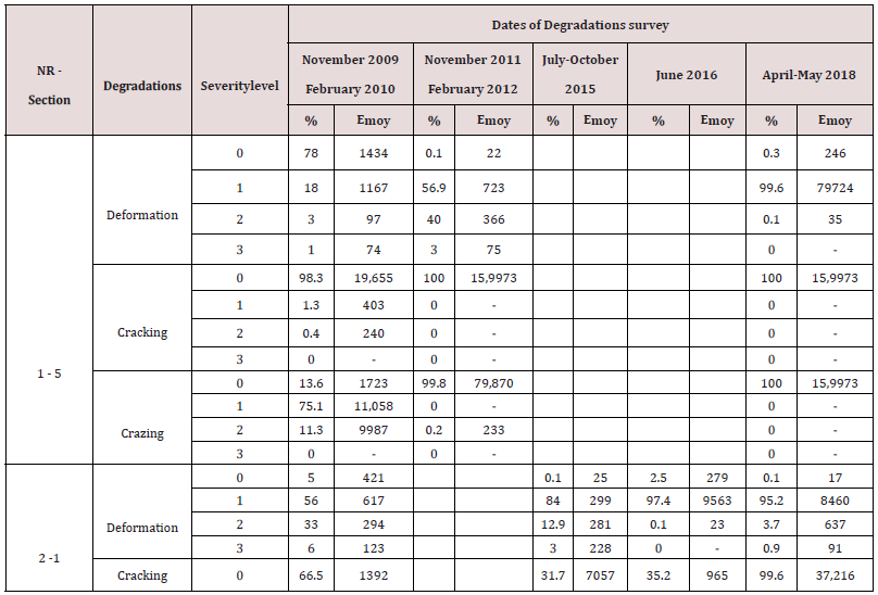
Statistical study of the selected sections’ types of degradation
The statistical study of each type of degradation consisted first of all in identifying, for the selected campaigns and sections, the percentage of total length (%) and the average extent (Eave) corresponding to each grade/level of severity level (Table 5). For example, for section 5 of NR No 1, the February 2010 campaign revealed that level 3 deformations represented 1% of the total length of the section and had an average extent of 74 metres. Level 2 deformations corresponded to 3% and 97 metres respectively; Level 1 deformations to 18% and 1167 metres; Level 0 deformations to 78% and 1434 metres respectively. The same data is displayed for the other campaigns and the other types of degradation (cracking and crazing), for the six selected sections.
For each section, these data then allow an overall interpretation of the pavement’s behaviour at a given date and/or over time. In brief:
• For section 5 of NR No. 1, in 2010, the pavement presented rather satisfactory viability since few deformations and cracks of severity level 2 and 3 were present. On the other hand, cracking was pronounced (86% of Gravities 1 and 2). It can therefore be deduced that the structure and the underlying subgrade were in a satisfactory condition but that the surface pavement was deteriorated. 1.5 years later (2011 campaign), the section was almost completely deteriorated, with a high rate of level 2 and 3 deformations (the characterization of cracking and crazing was probably no longer efficient). This very rapid evolution is a significant and revealing example of the (poor) performance of pavements in tropical environments. By 2018, almost the entire section was again in an acceptable condition (level 1 deformations) which is the obvious consequence of one or more repair/degradation phases during this interval;
i. For section 1 of the NR No. 2, in 2010, the pavement had poor viability with only 5% of the route free of deformation. 6% of the route had deformations of severity level 3 and cracking was significant. In 2015, the situation was “a little better”, with more level 1 deformations but less level 2 and 3 deformations, implying that the repairs carried out in the intervening period were losing their effectiveness. There was also more significant cracking and crazing than before and these parameters could therefore be considered as a preliminary phase which will lead to future deformations of higher severity level. In 2016, the general condition of this section showed fewer severe severity level deformations, with, however, a lot of cracking and crazing of severity level 1. As before, it can be assumed that the previous just repairs were being altered. In 2018, the pavement was in good condition, with mainly severity level 1 deformations but without much cracking and crazing, probably the result of recent structural maintenance;
ii. For section 2 of the same NR n° 2, in 2010 the pavement presented a very satisfactory general condition, with very little deformation, cracking and crazing. Two years later, the entire pavement presented a majority of severity level 1 degradations, notably deformations. In 2016, four years later, there were still as many severity level 1 deformations but less cracking and more crazing (effect of previous repairs). By 2018, severity level 1 cracking had increased;
iii. For section 6 of the same NR No. 2, the pavement was in a satisfactory condition in 2009.
Two and a half years later, severity level 1, 2 and 3 deformations had significantly increased. In 2015, the situation was even more difficult with an increase in severity level 3 pathologies. In 2018, large sectors of the section were still deformed but the severity levels were lower, with however a significant level of crazing (results of the periodic repairs carried out);
iv. For sections and 4 of NR No 3, the 2010 campaign had shown a majority of deformations of severity level 1 and 2 and significant crazing of severity level 2. In 2015, these pathologies were slightly less but still significant. In 2018, deformations of severity level 1 affected nearly 90% of the section;
v. For section 1 of NR No 5, in 2010, the pavement was almost completely deformed, with a high rate of level 2 and 3 deformations. There was also significant cracking and crazing. In 2012, severity level 2 deformations had increased. In 2018, the road was in satisfactory condition but with a high percentage of severity level 1 deformations.
This description shows that the condition of these pavements changes rapidly over the years, although the responses differ or are similar depending on the regions concerned. However, in the vast majority of cases, it is deformations that constitute the predominant deterioration and endanger the pavement, reflecting a loss of ground bearing capacity, or the use of pavement materials that are unsuitable for heavy goods vehicles which are often overloaded. A spatial study of this deterioration provides additional information. It consisted of classifying each survey by severity level level and plotting them on a map based on their coordinates (latitude, longitude), taking into account the central position of the deformation (generally small average extent). In this way, it is possible to locate each deformation geographically and to observe, for example, its evolution over time in terms of severity level and/ or pathology.
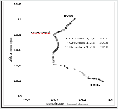
Figure 5 shows, as an example, the results obtained for the deformations found on section 5 of NR No 1, 1.5 years apart. It can be seen that the 2011 level 2 and 3 severity level deformations are very often localized at the level of the 2010 level 1 and/or 2 deformations, at least in the north-western part of this section. This result clearly illustrates the rapidity of the degradation which can be directly related here to the geological nature of the soils and even to the local climate. In this case, it is noted that the area concerned by deterioration is adjacent to the Tinkisso River (a tributary of the Niger River) and its tributaries, where important alluvial deposits of mostly clay and silt are found [Geological Map, 2006]. The numerous meanders of these rivers also reflect a depressed topography, where soils can be rapidly saturated during rainy periods (rainfall of 1000 to 1500 mm, Table 4). The rest of the section has less numerous and more localized disorders and the subsoil geology is mainly granitic in nature (laterites with little clay). Figure 6 shows the deformations found on sections 3 and 4 of RN No. 3, at three dates (2010, 2015 and 2018) between which routine and structural repairs were carried out. For this example, the three levels of severity level have been combined. It can be seen that recurrent deformations appear mainly on certain sections, starting from Boffa and before Koulaboui and then as far as Boké. According to the geological map, in these areas, the soils are mostly composed of argillites. The rest of the road is based on rather sandstone soils which clearly allow for better foundations (laterites less clayey) even in rainy periods. Similar correlations could be established on the other sections of the different RNs investigated.
Figure 5: RN 1, section 5 Dabola-Kouroussa. Comparison of the 2010 severity level 1 deformations to the 2011 severity level 2 and 3 deformations.
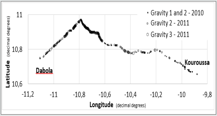
Figure 6: NR No 3, section 3/4 Boffa-Koulaboui-Boké. Comparison of the deformations recorded in 2010, 2015 and 2018, taking into account severity level.
Overall Assessment, Prospective Simulations This statistical study confirmed that the viability of the paved Guinean roads was rapidly altered by recurrent deformation problems linked a priori to the nature of the supporting soil (more or less clayey laterites depending on the geology of the region) and the probable evolution of its bearing capacity during climatic variations. The effects of heavy vehicle traffic and associated overloads were also found to play a negative role. To assess these aspects, prospective simulations were carried out using the Alize-LCPC software [Alize, 2016; Alize, 2018] initially considering a reference structure subject to several scenarios. This structure is that of a typical flexible pavement in Guinea, consisting of:
a) a class 3 BBSG3 semi asphalt concrete wearing course (6 cms);
b) a base course of good quality crushed or gravelly untreated crushed material of class 1 GNT1 (20 cms);
c) a base course of natural lateritic gravel (“gravelly lateritic”) of lower quality or TNG 3 (25 cms).
The overall characteristics retained for these materials, according to standard NF P 98-086 [NF P 98-086, 2019], are given in Table 6. It should be recalled that the sizing principles assume that these characteristics remain unchanged over time. The first step consisted of finding the average annual daily traffic that a pavement can bear to ensure that its service life is 15 years, i.e. that considered in the “Guide de Dimensionnement des Chaussées des Pays Tropicaux” CEBTP, [27]. This was assumed to be an annual traffic growth rate of 5%. The answer given by the software is 67 heavy vehicles per day (HVs/day), or T3- traffic (between 50 and 100 HVs/day) according to the Catalogue of New Pavement Structures Catalogue, [17]], i.e. total cumulative traffic of about 500,000 HGVs.
If traffic is higher, e.g. T2 traffic of 200 HVs/day, then the simulations give a lower pavement service life of only 6 years. If T0 traffic were to be even more intense (1200 HVs/day), the service life of the pavement would then only be 1.1 years. If we now consider a PF1 platform with a lower bearing of 20 MPa (loss of bearing of the PF2 platform), the 15-year service life would be ensured if the traffic did not exceed 6 HVs/day, i.e. T5 traffic (0 to 25 HVs/ day). Assuming the “initial” traffic is retained (T3-, 67 HVs/day), the pavement service life is then only 1.8 years. For T2 traffic (200 HVs/day) the service life of the structure would be only 0.65 years. Finally by keeping the same PF2 platform and the same T3- traffic of 67 HVs/day but increasing the axle load by 25%, the service life would be 8.5 years. These simulations clearly show, if needs be, the importance of traffic intensity but above all of the bearing capacity of the roadbed in relation to the service life of a pavement. The resulting recommendations are therefore to better define and characterize the bearing capacity of the various lateritic soils in tropical environments during climatic variations and to integrate the results into the principles of pavement design. This study makes it possible to locate a variety of sectors where lateritic soils could be used to conduct a dedicated research programme which would address the changes in bearing capacity and material dimensions during climatic cycles.
A study would also be required of the possibilities of in-place treatment of the support soils with hydraulic binders possibly associated with lime NF P 94-102-1, [44, 45] in order to obtain a form layer that would improve the bearing capacity of the platform. In this respect, simulations show that with a PF3 platform (120 MPa modulus), the initial structure could cope with T1 traffic of 540 HVs/day over the 15-year service life, or even T3- traffic (67 HVs/day) over the same service life but without the presence of the foundation layer (base and surface layers only). These results clearly show the economic and environmental benefits of aiming for a high-performance and durable subgrade to ensure the viability of road structures, particularly in tropical climates. Finally, the need to carry out the work according to the rules of the trade should also be noted again including in particular soil treatments (treated soil covered with a gravel plaster can be used as a temporary pavement) and also to ensure the structures’ durability by ensuring that lateral drainage is always efficient[ 46-51].
Conclusion
This general study based on the periodic surveys of pavement deterioration in Guinea, contained in the Viziroad Road Database provides “quantified” information on the durability of roads in tropical environments. The processing of these data shows that routine and periodic maintenance, or even structural repairs carried out locally, are not very durable since these pavements are subject to recurrent deterioration which is often located in the same areas or in the same places along the route. These degradations are mainly caused by structural deformations, marked by collapses and pronounced ruts. The causes of these disorders are linked to the intensity of heavy vehicle traffic (overloads) but obviously also by the variation in the bearing capacity of the lateritic support soil, between dry and wet periods, as confirmed by the simulations carried out with the Alize software. The aim of this work is not to provide technical solutions at this stage but rather to once again demonstrate the need for methods to be developed for dimensioning pavements in tropical climates. In particular, this would involve defining more appropriate methods or tests for characterizing the evolution of the bearing capacity of lateritic soils and their dimensional variations when they are subjected to repeated variations in their hydrous state. Scientific research is being carried out in this respect on the basis of typical lateritic sites identified as a result of this study. This would also require recommending realistic technological solutions to implement under the best conditions solutions found in the laboratory based on the treatment of soils with hydraulic binders in particular.
Thanks
The authors thank the Ministry of Public Works of Guinea for providing access to the data. They also thank the Ministry of Higher Education and Scientific Research for its financial support for Ms Sidibé’s stay in France. Finally, they thank Messrs Salmon and Lovo of the DIREST in Nancy and Mr Corlay of the Colas Est company in Nancy for their scientific assistance.
References
- Fwa, Fwa TF(1987) Water-induced distress in flexible pavement in a wet tropical climate, Transportation Research Record 1121: 57-65.
- Jayakumar Soon, Jayakumar M, Soon L Ch, (2015) Study on Flexible Pavement Failures in Soft Soil Tropical Regions, OP Conf. Series: Materials Science and Engineering 78.
- Muthuramalingam Soon, Muthuramalingam J, Soon L (2015) Study on flexible pavement failures in soft soil tropical regions, 9th Curtin University of Technology Science and Engineering International Conference, 2014 (Cutse2014)
- Razli, Razali M, Che Mahmood NA, Hashim K A, Mansor S, et al. (2018) The falling weight deflectometer (FWD) for characterization bonding state of subgrade, Advances In Civil Engineering And Science Technology, Penang, Malaysia 2018, AIP Conference Proceedings 2020 (1).
- Medina Medina J (1986) Classification of tropical soils according to resilient characteristics for pavement design, International journal of rock mechanics and mining sciences & geomechanics abstracts, 23(3): 91-91.
- Ramana, Ramana KV (1993) Humid tropical expansive soils of Trinidad: Their geotechnical properties and areal distribution, Engineering geology 34(1): 27-44.
- Akpan and Edet, Akpan O, Edet A, (2005) Relationship between road pavement failures, engineering indices and underlying geology in a tropical environment, Global Journal of Geological Sciences 3(2): 99-108.
- Camapum de Carvalhoa, Camapum de Carvalho J, de Rezende LR, da Cardoso F B, de FL Lucena LC, et al. (2015) Tropical soils for highway construction Peculiarities and considerations, Transportation Geotechnics 5: 3-19.
- Guimarães, Guimarães ACR, da Motta LMG, Castro CD (2019) Permanent deformation parameters of fine - grained tropical soils, Road materials and pavement design, 20(7): 1664-1681.
- Medina, Medina J (1989) Tropical soils in pavement design, Proc 12th International Conference on Soil Mechanics and Foundation Engineering, Rio de Janeiro 543–546.
- Mahalinga Iyer, Williams, Mahalinga-Iyer U, Williams D, (1997) Properties and performance of lateritic soil in road pavements, Engineering geology 46(2): 71-80.
- Caro, Caro S, Agudelo JP, Caicedo B, Fernanda Orozco L (2019) Advanced characterization of cement-stabilised lateritic soils to be used as road materials, The international journal of pavement engineering, 20(12): 1425-1434.
- Mengue, Mengue E, Mroueh H, Lancelot L, Medjo Eko R (2018) Design and parametric study of a pavement foundation layer made of cement-treated fine-grained lateritic soil, Soils and Foundations, 58(3): 666-677.
- Somparé, Somparé M, Loua H, Nkouma Emane T, Kouzonde A (2018) EGIS International, Assistance technique au projet d’appui au secteur des transports, Restitution mission connaissance du réseau et relevé de dégradations sur le réseau parcouru, 55.
- Autret, Brousse, Autret P, Brousse JL (1991) Méthode assistée par ordinateur pour l’estimation des besoins en entretien d’un réseau routier, Techniques et méthodes des Laboratoires des Pontset Chaussées, Méthodes 63p.
- SETRA/LCPC (1972) Catalogue de dégradation des chaussées, Ministère de l’équipement et du logement, Edition : 125.
- LCPC (1998) Méthode d’essai n° 52, Complément à la méthode d’essai n° 38-2, Catalogue des dégradations des surfaces des chaussées, L’entretien courant des chaussées, Guide pratique, Edition.
- Autret, Autret P, Latérites (1983) graveleux latéritiques, LCPC, Institut des sciences et des techniques de l’équipement et de l’environnement pour le développement 38 p.
- Mamedov, Mamedov VI, Booféév YV, Nikitine YA (2010) Géologie de la république de Guinée, Volume I, Ministère des mines et de la géologie de Guinée, Geoprospects Ltd, Université d’Etat de Moscou.
- Lacroix, Lacroix A, (1913) Les latérites de la Guinée françaises et les produits d’altération qui sont associés, nouvelles archives du Museum d’histoire naturelles.
- Alize-LCPC (2016) Ifsttar-ITECH, Alize-Road - User manual, version 1(5).
- Alize-LCPC, Remaud D, Roure P, Blanc J, Piau JM, (2018) Logiciel Alisé-LCPC, Analyse et dimensionnement des structures de chaussées, Revue Générale des Routes et de l’Aménagement 258: 50-59.
- NDiaye NDiaye M (2013) Contribution à l’étude de sols latéritiques du Sénégal et du brésil, Thèse de Doctorat, Université de Paris Est/Université Cheikh Anta Diop de Dakar 160.
- Lyon Associates (1971) Les sols latéritiques et d’autres sols difficiles d’Afrique, Études géotechniques pour USAID-Lyon Associates, Maryland USA-BRRI, Kumasi, Ghana.
- Bagarre, Bagarre EJ, (1990) Utilisation des graveleux latéritiques en technique routière, Synthèses, Institut des Sciences et des Techniques de l'Equipement et de l'Environnement pour le Développement (ISTED), 148 p.
- NF P 11 300 (1992) Earthworks, Classification of materials for use in the construction of embankments and capping layers of road infrastructures, AFNOR, Marne-la-Vallé
- CEBTP (1984) Guide pratique de dimensionnement des chaussées pour les pays tropicaux. Ministère des relations extérieures - coopération et développement de la république française, 157 p.
- NF P 94-078 (1997) Soil: investigation and tests, CBR after immersion. Immediate CBR. Immédiate bearing ratio, Measurement on sample compacted in CBR mold, AFNOR, Marne-la-Vallé
- NF P 94-051 (1993) Soil: investigation and testing, Determination of Atterberg’s limts, Liquid limit test using Casagrande Apparatus, Plastic limit tests on rolled thread, AFNOR, Marne-la-Vallé
- NF P 94-093 (2014) Soils: Investigation and testing, Determination of the compaction reference values of a soil type, Standard Proctor Test, Modified Proctor Test, AFNOR, Marne-la-Vallé
- Rodrigues, Rodrigues JKG, Reiffsteck P, Auriol JC, Ndiaye M (2010) Rationalisation de l’utilisation des sols latéritiques en corps de chaussée durable et de faible coût, XXVIIIémes Rencontres Universitaires de Génie Civil, Session Ouvrages – Bitume, 1122.
- NF EN 933-9+A1 (2013) Tests for geometrical properties of aggregates, Part 9: Assessment of fines, Methylene blue test, AFNOR, Marne-la-Vallé
- NF XP P 94-060-1, (1997) Investigation and testing. Shrinkage test. Part 1: determination of shrinkage characteristic on remoulded soil passing a 400 micrometers test sieve, AFNOR, Marne- la-Vallé
- NF P 18-576 (2013) Aggregates, Determination of a sand friability coefficient, AFNOR, Marne-la- Vallé
- NF P 94-066, (1992) Soil: investigation and tests, Fragment ability coefficient of rocky material, AFNOR, Marne-la-Vallé
- NF P 94-067 (1992) Soil: investigation and tests, Degradability coefficient of rocky material, AFNOR, Marne-la-Vallé
- Egis International (2012) Etude d’actualisation des APD et DAO de projets routiers en Guinée – RN2 entre Kissidougou et Guéckédou (PK35), Etude gé
- LCP 38-2, Bertrand L, Lepert P, (1997) Relevé des dégradations de surface des chaussées, Méthodes d’essai 38-42.
- IQRN (2015) Politique de l’entretien des chaussées du réseau routier national non concédé, Volume 3, IQRN et indicateurs d’usage, Manuel de présentation, Ministère de l’écologie, du développement durable et de l’énergie, 25.
- Autret , Autret P (1997) Étude des routes non revêtues, VIZIRET Système de gestion de l'entretien d'un réseau routier, Bulletin des Laboratoires des Ponts et Chaussées 210: 3-22.
- Nguyen, Nguyen TS, Vrignat P, Avila M, Begot S, et al. (2007) Détection de défauts sur la surface de chaussées par système de vision, Colloque GRETSI, Troyes.
- Autret Brousse, Autret P, Brousse JL, Viziret (1998) qualification et quantification des dégradations d’une route non revêtue pour la programmation et le suivi des travaux, Bulletin des Laboratoires des Ponts et Chaussées 17-31.
- NF P 94-117-1, (2000) Soils: investigation and testing, Formation level bearing capacity, Part 1: Plate test static deformation module (EV2), AFNOR, Marne-la-Vallé
- Autret Brousse, Autret P, Brousse JL, Viziret (1998) qualification et quantification des dégradations d’une route non revêtue pour la programmation et le suivi des travaux, Bulletin des Laboratoires des Ponts et Chaussées 17-31.
- NF P 94-102-1 (2001) Soils: Investigation and testing, Soil treated with hydraulic binder, possibly combined with lime, for use as a selected fill, Part 1: Definition - Composition - Classification, AFNOR, Marne-la-Vallé
- Carte Géologique, Bouféév Y, Mamédov V (2006) Carte géologique de la Guinée, échelle 1/500 000, Moscou.
- Catalogue (1998) Catalogue des structures types de chaussées neuves, EDITION 1998, SETRA, LCPC.
- Directives Guinée (2018) Directives Générales pour les Normes de Conception, Construction et d’Entretien des Routes et Pistes en République de Guinée, Ministère des travaux publics, Ministère de l’Agriculture 37.
- IQRN (2000) Note d’Information IQRN n° 110, SETRA, 8 p.
- [NF P 98-086, 2019] Road pavement structural design, Application to new pavement, AFNOR, Marne-la-Vallé
- SETRA (1996) L’entretien courant des chaussées, Guide pratique, Edition: 119.

Top Editors
-

Mark E Smith
Bio chemistry
University of Texas Medical Branch, USA -

Lawrence A Presley
Department of Criminal Justice
Liberty University, USA -

Thomas W Miller
Department of Psychiatry
University of Kentucky, USA -

Gjumrakch Aliev
Department of Medicine
Gally International Biomedical Research & Consulting LLC, USA -

Christopher Bryant
Department of Urbanisation and Agricultural
Montreal university, USA -

Robert William Frare
Oral & Maxillofacial Pathology
New York University, USA -

Rudolph Modesto Navari
Gastroenterology and Hepatology
University of Alabama, UK -

Andrew Hague
Department of Medicine
Universities of Bradford, UK -

George Gregory Buttigieg
Maltese College of Obstetrics and Gynaecology, Europe -

Chen-Hsiung Yeh
Oncology
Circulogene Theranostics, England -
.png)
Emilio Bucio-Carrillo
Radiation Chemistry
National University of Mexico, USA -
.jpg)
Casey J Grenier
Analytical Chemistry
Wentworth Institute of Technology, USA -
Hany Atalah
Minimally Invasive Surgery
Mercer University school of Medicine, USA -

Abu-Hussein Muhamad
Pediatric Dentistry
University of Athens , Greece

The annual scholar awards from Lupine Publishers honor a selected number Read More...


